By Vicky · Published Feb. 22nd, 2021 · Updated Dec. 10th, 2022
The beautiful Cederberg Wilderness Area is only 2.5 hours from Cape Town. If you like spectacular rock formations, fynbos and beautiful sunsets, this is the place to be. We went there for a long weekend over Easter 2019 and did our best 4-day hike in South Africa.

Page Contents:
Location
The Cederberg Wilderness Area is located in the Western Cape in South Africa. The closest town is Clanwilliam, a small quaint town in the Olifants River valley. If you are coming from Cape Town, a 218km drive, take the N7 north through Citrusdal and take the mountain pass to Algeria/Cederberg. The start of this 4-day overnight hike is at the Cape Nature Algeria Campsite, where you also have your permits checked at the Cape Nature office.
Cederberg Overnight Hike Map
Get the route by downloading the .gpx or .kml file below. For navigation with Maps.me on your mobile phone, simply download the .kml file and open to add it to the Maps.me bookmarks.
We set off on Thursday afternoon, at around 2:30 pm. After leaving the traffic of Cape Town we sped along the N7 north, through landscape that became ever wilder. Passing by Citrusdal we saw our first glimpse of the mountains. Dramatic.
Camping at Algeria
We spent the first night camping at Algeria, having made a reservation on the Cape Nature website. It is advisable to book if you will be there on the weekend or during public/school holidays. We randomly picked Site 1. It turned out to be a good one. The site was at the end of the campsite, so there were only people on one side of us. It was also quite a big site, not far from the restrooms and had both sun and shade. And three tables, just in case. We thought that the site closest to the mountains would be a good alternative.
Tips
- Make a reservation if you are staying at Algeria campsite the night before the hike, especially during the weekend or holidays.
- You also need a permit for hiking from Cape Nature.
- The road east across Olifantsrivier from the N7 is a dirt road but can be driven in a normal car. Check out the Best Road Maps for South Africa.
- Slingsby Maps of the Cederberg are essential – there are no signs in the wilderness area.
- It is quite easy to extend this 4-day hike by a day or two.
- We used a UV water filter for this hike, but on other occasions we drank straight from the streams.
- Bring a sunhat and sunscreen, as there is little shade.
- Make sure to take enough water bottles – at least 2 litres, 3 litres in summer, as streams to refill water are sometimes far apart.
- Boots covering the ankle help against twisting your foot, and also give some protection against potential snake bites.
- Winter would be cold, and summer hot with little water – so spring and autumn are the best times to go. We went over the Easter Weekend.
- For a two-day overnight hike in the Cederberg, try hiking up Sneeuberg, or discover other ideas for hikes in South Africa.
Day One

The next morning, our alarm went off at 8:30. But we were very slow getting ready and we only started hiking at around 11 am… Not so much of the early start we were hoping for. It is best to get up early to beat the day hikers on the way up to the waterfall and to hike in the cool of the morning.
Initially, it was a fairly steep upward slog up Helsekloof. Not really a slog though, because we were feeling fresh and energetic. But also our backpacks were the heaviest they would be. There were a few paths near the beginning – make sure to stay on the right-hand side of the stream. Then the path zigzags upwards. It’s worth the short detour to the waterfall (signposted), as it is very scenic. Then back the way you came and continue upwards to the top.
We noted a super great-looking secret camping spot just at the top of the climb, if you start the hike early in the afternoon. It would take 1.5-2 hours to hike there, and then the sunset would have been amazing. Just behind a rock in a flat space right at the top of the initial ascent.
And at the top, wow, a whole new world! And flat! Unlike mountainous areas in the rest of the world, where you arrive at the top and then it slopes down again, in South Africa it is full of plateaus. So you start at a flat place, go up along a river, and at the top you get to another flat place.
Bark of a Baboon
The landscape was so amazing on the first day. The rocks, the colour of the grass, more rocks, funny-shaped rocks, wide horizons. After a while, we heard a loud kind of barking noise. We were wondering what it was, when we saw a troupe of baboons. I was a bit scared, but they didn’t seem to be the aggressive types that have been used to human contact and try to steal your food. Instead, we scared them and they ran away. That bark had been to warn their troupe that danger was approaching. So they jumped up a mountain and sat looking at us. Some remained slightly close to the path. We walked quickly through this area, forgetting about the real danger – snakes. But actually, we didn’t see any of those on our entire trip.
Near the end of the day, we turned up at such a magical verdant valley, with the light of the setting sun and the golden green colours and flowers and rocks again. Then there was a last uphill section to a new plateau, with wild views and swirling clouds up above. Actually not sure if there were clouds, might be making that up…
Crystal Pools Camp
We spied a tent already at ‘the Crystal Pools camp’ marked on the map, so we camped just before the stream on the left hand side of the path, where obviously people had camped before and the ground was flat and sandy.
We set up our tent, brewed some tea (some for now, some to keep in the thermos for later), and went to view the sunset. That was terrific, one of the best sunsets I’ve ever seen. The colours were just incredible and framed by dark purple rain clouds into a perfect painting. The blues, the yellows golds and orangey reds. Even the greys were amazing. But the blues, so blue! So light blue, so yellow, and so many different cloud shapes. Stringy, bubbly, layery.
For dinner we had instant noodles with cheese. Quick to cook, warm, salty and cheesy. Nice. Then our secret thermos tea we’d made earlier. And it wasn’t too cold out either, and no mosquitoes, so good times. Then we went to bed.
History of the Cederberg
It is called the Cederberg because Ceder trees grow there. A lot were cut down to make telephone poles and furniture. The area has been inhabited for a very long time, and there are numerous San rock paintings that are roughly 2000 years old. Some of these sites can be visited. Though many are on private land, or not marked on maps. There also used to be elephants here, which is why one of the rivers is called Olifants River.
The first farm site here was in 1732, and Clanwilliam still has some early architecture. It was really too dry though for farming until dams were built in 1914 and 1953 for irrigation. The Cederberg was proclaimed a nature reserve in 1973 to help protect the remaining Ceder trees.
Day Two
On the second day of our 4-day walk, we again assumed we would have an early start, but we didn’t manage to leave until around ten. We filled up our water at the stream (using our UV water filter) and set off into more gorgeous valleys and plateaus. After the initial ascent through a rocky ravine, we reached the jeep track, which was to be our path for the day.
We thought it would be fast walking, but actually it was either rocky, sandy, or had holes. Sometimes really big holes, like erosional gullies, taller than a person. A jeep definitely couldn’t get up there now. Unless it was a VW Golf Land Rover Defender.
Tafelberg (Ketelberg)
Wide landscapes, and views for miles. But still with lots of changes as we rounded the corners of the track. We laughed at our first site of Tafelberg (Ketelberg) – that is how it is written on the maps, Tafelberg (Ketelberg). It looked just like a kettle/teapot. We couldn’t understand why that name was in brackets, and Tafelberg (Table Mountain) was the main name, until the next day when we were demystified. The weather was just perfect. Sunny and brisk. We ate lunch today – the only day we did. This was just before Welbedacht Cave turnoff.
Geology of the Cederberg
The cool rock formations of Cederberg have been sculpted by wind and water for millions of years, moulding them into their amazing shapes. It is pretty much all sandstone and shale – the sandstone being a lot harder and more resistant to erosion than the softer shale. As a geologist, this area is really fascinating and the geology is definitely a major part of the reason why this is our favourite 4-day hike in South Africa. Next are some cool geology facts.
Jeep Track Shale Band
The jeep track that you walk along follows a band of shale between sandstone layers. Since the shale is softer, it can’t make such steep slopes, so this flat area is one of the only places where a jeep track could easily be built. Grass can also grow here, unlike on the super rocky slopes above and below.
Rock Falls
Everything that goes up must come down. Sometimes boulders roll down the slope – you can see in the photo the track that a boulder has left on the slope from its roll down the hill. This boulder must have been a bit unstable, and then suddenly, maybe because it rained a lot and the ground was slippery, it rolled away. I think it’s that boulder in the grass you can see at the lower right edge. Eventually, the rock making up this boulder will reach the ocean – this short roll was its first step.
Cross-bedding
This rock is a great example of cross-bedding – groups of inclined layers at an angle to the horizontal. These can be formed either by water or wind – often on land as sand dunes. Imagine sand dunes with their sloping edges, these can get preserved in the rock record.
Secret Camping Spot
We were planning to go as far along the jeep track as we could before leaving the Cederberg Reserve and entering private land, as you have to get a different permit if you camp on the private land (you can camp at Sandrif Campsite and then pay the permit the next day in the shop at Dwarsrivier). I thought our campsite would be boring, like just on the edge of this jeep track, also known as the shale band – see the geology section for details. But just when we were thinking about stopping, we saw some magical rocks on the right of the path about 100 m away. It looked super great so we went there. Tucked just behind a rock out of sight of the track in a cosy secret little spot – not that we saw any people today anyway.
Even though we felt we had picked the spot at random, there were rocks arranged in such as way as to indicate that other people had camped here at one time. We were again on a nice little sandy patch. I definitely felt a spiritual energy about the place, by that I mean ‘we were drawn to this special place by the pull of the rocks’. I was sure there would be rock carvings here and had a brief look (too tired for a thorough search), but I found nothing. It was a super magical place though.
The sunset was less good than yesterday (could any sunset be better?) but the few wisps of cloud turned very pink, and we happily drank our tea and ate our dinner of the evening – freeze-dried spaghetti bolognese. But not freeze-dried when we ate it because we added 800ml of boiling water and then waited a very long 8 minutes like the instructions said.
Day Three
We managed to get up a bit earlier the next day, and left at 9:01, after a great night’s sleep. We had a long day ahead, 24 km and 880 m climb. Today we had to cross the valley. We walked down, via ‘protea valley’, so many nice rocks, and also protea.
There was a fire in 2016 in this part of the Cederberg, and parts of it have been closed for a while. The vegetation has regenerated quite well after the fire. There are still a few burnt proteas, but it is now full of new life, and new proteas springing up everywhere. The stunning Wolfberg Arch is not so far away from this area. It was closed due to the fire, and it was still closed when we were there (April 2019), otherwise we might have gone via the arch and down the Wolfberg cracks. But for that detour, we would have had to add another day or make the route shorter elsewhere.
Across the Valley
We passed through Sanddrif Holiday Resort, to Dwarsrivier farm, home of Cederberg Wines, where we bought a coke and some crisps (Simba, Mrs Balti Chutney Flavour, my favourite), yum delicious. We also got a beer from their brewery for later, the Chatterbox Crystal Weiss. Which apparently was very good according to Tom, and I also thought that it tasted like beer. Useful to know is that the store has free wifi, in case you need to look up this hike report.
We passed a cute little observatory and then back into the wild. We hiked this section pretty fast – averaging 6km/hour for a couple of kilometres. The dirt track led to a small car park – this is where people start the Maltese Cross hike from. We were running out of water, and it was very hot. The little stream shortly after the car park was a life-saver. We refilled all our water (and filtered it using our UV filter) then had a deliciously refreshing paddle.
Flora and Fauna of the Cederberg
The flora and fauna were one of the reasons why this was our best 4-day hike in South Africa. We saw many birds, baboons, and a klipspringer’s head (living). The other animals that you might see include other small antelope such as rhebok, duiker and grysbok. There are leopards in the area. This sounds scary, but there are leopards in most places. They are very shy and relatively small, and I don’t think hikers have ever been attacked by them in this region. They are not commonly seen – if you’re lucky you may see paw marks or leopard droppings. We thought that *maybe* we saw some leopard footprints. For sure a cat, but maybe actually a smaller one like a caracal. Snakes such as puff adders and Cape cobras also occur in the region, so be alert.
Beautiful Protea
Flora-wise, the Cederberg is full of mountain fynbos (for more info about fynbos click here). The proteas were very recognizable. And of course, there were some cedars.
The Sugar Bush Protea used to be the main source of sweetener in the Cape Region. Cederberg fynbos is also the home of rooibos! Which is available to taste and buy in the region.
The Clanwilliam cedar tree grows in rocky areas high up, between 1200 and 1700 m. They are one of only two indigenous pine species in Africa. This cedar is not a ‘true’ cedar but has similar characteristics such as durable, fragrant wood. It does smell nice. In the surrounding towns, you can get lots of soapy type products made out of cedarwood or sap or something. On this hike you can see many old cedar plantations – after centuries of harvesting the cedarwood, this species is a lot less common than it used to be. Climate change is now also causing the cedar to disappear.
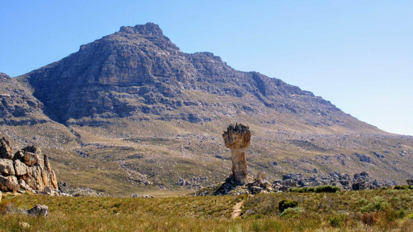
The Maltese Cross
Next up, a steep 400 m climb up to the Maltese Cross. This was the only section where we saw any other people. Luckily there was some shade on the way up. Arriving at the Maltese Cross is quite spectacular, as you can see it for a while in the distance and the closer you get, the larger it becomes. There are many other interesting rock formations on this hike but the Maltese cross is definitely special.
This day was quite long. We still had a way to go before our campsite, in the Sneeuberg Hut area, but the views compensated for our tired legs.
Along the plateau, then up and down, over the saddle to our first sight of Sneeuberg Hut – which was very disguised and semi built into the rocks. We were actually heading just past the hut to what is called ‘Gorgeous Rocks’ on the Slingsby maps, as we thought this would be a great place to camp, which it was.
Surprisingly, given that this was our longest day (about 24km), we got there the earliest. Before getting into our routine of setting up the tent and making tea, we cracked open our beer to share and took some photos. It was very nice beer. We should have bought more than one.
Day Four
The next day came as quite a surprise – we thought it would be fairly flat just through a valley. But actually (and if we’d looked closer at the map) it was down and along the side of a super dramatic steep gorge, called Duiwelsgat (Devil’s Hole). Before climbing back out of it to another saddle. After Duiwelsgat you reach another plateau. At the end of this plateau, we encountered loads of flowers, a sea of proteas. Not much later we saw our final valley back down to the road, which we then hiked along for about 5 km back to the Algeria campsite and our car.
Our Top 4-Day Hike in South Africa
This was truly our best 4-day hike in South Africa. First of all, there is a real wilderness feel although you are so close to civilization and Cape Town is a mere 2.5 hours drive. Secondly, you are free to choose any of the many paths and change your mind along the way. Also, the protea and fynbos are absolutely stunning in places. Above all, the rock formations are second to none, especially during one of the many spectacular sunsets.
Trip Extension After 4 Days of Hiking?
There is plenty to do in the area. For instance:
- Various other hiking routes!
- Extend the finest 4 day hike in South Africa with an extra day or two by 1) climbing to the top of Ketelberg/Tafelberg, 2) going via the Wolfberg Arch and down the cracks, 3) ascending Sneeuberg, the highest peak (2026 m) in the Cederberg.
- Explore the world of Rooibos tea production in the region.
- Visit the San rock paintings in the area.
- Buy some veldskoen shoes and learn about riel dancing in Clanwilliam.
- Visit the Cederberg winery for a tasting session, or just buy a few bottles from the local supermarkets to take home.
- Shop for cedar-based products
Clanwilliam
Unfortunately, when we got back to our car (around 1:30 pm), it wouldn’t start! Not with jump-starting either. So we had to call a tow truck, for which we had to wait ages as it was Easter Monday… Eventually we were towed to Clanwilliam, a small quaint town over the mountain pass and north up the N7 highway.
In Clanwilliam, we stayed in a nice place (see Accommodation Options), and bought local wines in the huge Spar. We got a Shiraz with infinitely many gold stickers on, and Bukettraube, which is sweet and delicious (According to Vicky), both grown in Cederberg. Then finally the next day, we made it back to Cape Town. An amazing trip.
Accommodation Options
We camped at Algeria campsite the night before we started. You need to book a spot here, especially on weekends when it gets busy. If Algeria campsite is full, Lylius Cottage and Campsites* is a great alternative on the main road side of the mountain pass. It’s also a good place to stay if you arrive late and don’t want to drive over the pass in the dark.
It would also be convenient to spend a night before either in Citrusdal (south towards Cape Town) or Clanwilliam (north). We spent the night afterwards at Saint du Barrys BnB in Clanwilliam – it was really nice, and the breakfast was very delicious and homemade. Part of why we think this is our top 4-day hike in South Africa is maybe due to this breakfast afterwards… The De Kelder Pub and Grill was also surprisingly good for dinner, especially if you are hungry after this long trek, and just a few minutes walk away.
If you enjoyed this hike, try hiking up Sneeuberg or check out our other hikes in South Africa.
Related Posts


Good day,
i am interested in the ceder berg hike and would love to do it in Aug 2022 if you have space available in n group. I am only one hiker.
Kind Regards
Ane de Goede
Hi Ane,
Unfortunately we don’t organise hikes, but only report on them. We did this hike by ourselves, but it does require some experience with backcountry camping and route finding.
Best regards,
Tom
Hi,
An interesting read. Thank you.
Do you perhaps have a GPX tracklog that you would be willing to share?
Thanks, Christine
Hello Christine, we haven’t implemented a link to the gpx track on our website yet, but if you send us an email at [email protected], I’m happy to send it to you.
Hallo, thank you so much for the lovely report!
When would you recommend is the best time of year to do this hike?
We did it in April. Generally spring and autumn are good times to do this hike, as summer is (too) hot and winter may be cold.
Hey guys
Could you let me know which permit we need to get? A 4 day permit for Cederberg wilderness area?
Thanks,
Elisa
Hi Elisa,
Yes, you need to email [email protected] to get a 4-day hiking permit for Cederberg Wilderness Area.
You need to give them the following information (if they need more information, they’ll email you back):
· Title (i.e. Mr., Mrs., etc.) –
· Name and Surname –
· ID Number –
· Postal address –
· Contact numbers (work, home, cell) –
· Fax number
· Name of the reserve – Cederberg
· Type of your enquiry (i.e. accommodation, camping, hiking, etc) – e.g. Hiking
· Number of people (note: children are between 2 – 13 years old) – e.g. 2 adults
· Preferred Arrival date and Alternative date – e.g. Start Friday 19th April from Algeria Camping
· Preferred departure date and Alternative date – e.g. End Tuesday 23rd April at Algeria Camping
· Wild Card number –
hope that helps,
Vicky at Ostrich Trails
Hi guys! Myself and my fiancé have planned to do your route and booked already at Algeria for the night before. However, we have been told by Cape Nature they won’t allow us to do overnight hikes unless there are 3 of us or more. Is this the case? How did you manage to do it the 2 of you?
Regards
Nathan
Hi Nathan,
At the Algeria Cape Nature Office we were told we just had to sign an extra indemnity form if just two of us went hiking. You could check whether this is still an option, I hope the regulations haven’t changed!
If you are not allowed, you can still do some lovely day hikes in the region – perhaps one similar to the first day, one up to Wolfberg Arch, one to the Maltese Cross and potentially further to Sneeuberg Peak, or a half-day hike north of Kliphuis.
I hope that helps,
Vicky
Hi,
Thank you very much for the description of the trekking. Do we need a guide for this hike?
Best,
Hi Hazem,
you don’t need a guide for this hike.
The only thing you need is a permit from Cape Nature (email [email protected]),
thanks,
Vicky