By Vicky · Published Sep. 20th, 2021 · Updated Nov. 24th, 2022
When you buy through links highlighted with an asterisk (*) on this site, we may earn a small affiliate commission at no cost to you.
Hike up to an amazing mountain hut near the top of Arangieskop, then down down down the next day, all with beautiful views and dramatic scenery.

Location
We parked the car just opposite Dassieshoek hut, by the entrance to the Dassieshok Nature Reserve, where the hike starts. It’s a bit in the middle of nowhere, and the car park is just a dirt area beneath some trees. To get here you have to follow a few kilometres of good dirt road. It’s just over 2 hours from Cape Town, so perfect for a weekend trip. If you don’t have a car, check out the options for car hire* from Cape Town.
Arangieskop Hiking Trail Map
Get the route by downloading the .gpx or .kml file below. For navigation with Maps.me on your mobile phone, simply download the .kml file and open to add it to the Maps.me bookmarks.
Tips for Arangieskop Hike
- There is braai wood at the hut – you need to light a fire to get hot water – but there is no stove, so if you want to cook something not on the braai then bring a small stove.
- There are mattresses on bunk beds, but you need to bring a sleeping bag and pillow.
- There are several spots along the trail where you can fill water bottles.
- Click here for a hiking map, which can be picked up at tourist information offices in the vicinity.
- To get an early start, stay in Robertson* the night before.
- You need a permit from Langeberg Municipality (R190.50 pp): [email protected], +27 23 615 8086
On Day 1 we took 6 hours to hike 9.5 km, with 1260 m climb uphill and 120 m down. On Day 2 we took 5 hours to hike 10.5 km, with 320 climb uphill and 1460 m down.
Day 1 of Arangieskop Hike
From our car, we set off through the gates into the reserve. Almost immediately, we came across a crew of baboons, but they were afraid of us and ran away.
After a few minutes of walking flat, the rest of the day was all uphill! That is, apart from the slightly depressing stretches of downhill, as we knew we’d have to regain this height later. But the sun was shining and we made good progress.
The Robertson Hiking map description mentions steel ladders and chains, but these are only in two places on the way up and are not difficult. Actually the most difficult part of the hike was descending from the summit. It is very steep (not for those afraid of heights) and there are a few ladders. It is a very long way down and you have to carefully watch your footing the entire time.

There are two potential swimming places (both marked on the map) on the way up. The left photo shows the first opportunity, a fairly shady patch where we ate lunch. The photo on the right shows a beautiful little pool almost at the top. We had a very quick dip. It was very cold because it was almost winter.
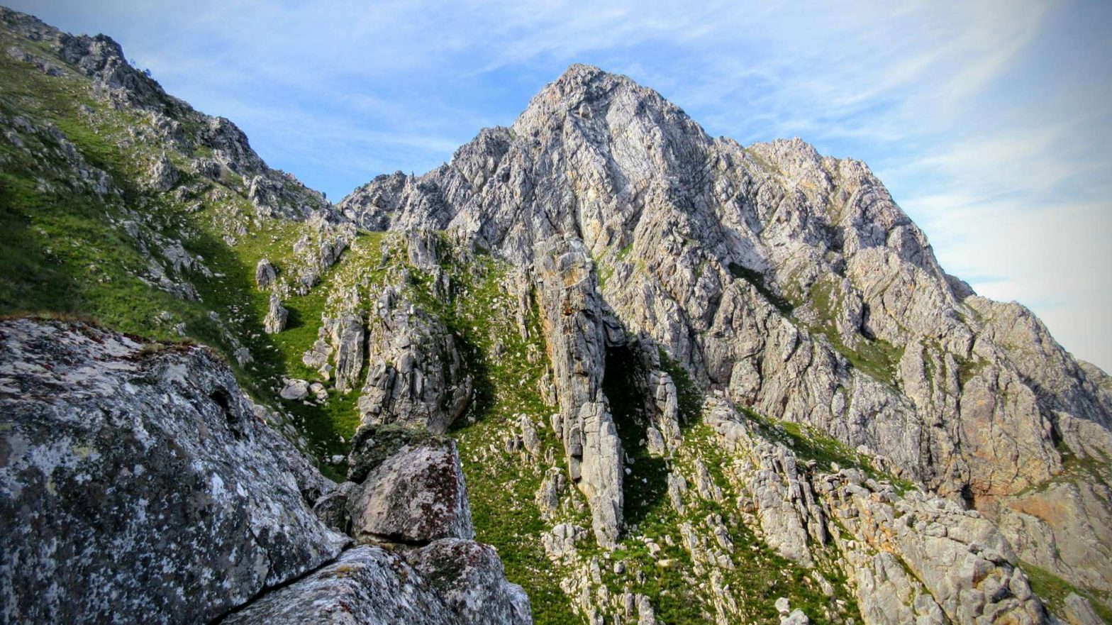
Climbing higher up, we got fabulous views over the valleys and really spectacular rocks.
At the top of Arangieskop
At the top, the hard sandstone becomes softer shale, which erodes to allow shallower slopes and the formation of soil and grass. There are various tracks here where the tractor comes up. It starts in Montagu on the other side and chauffeurs people up twice a week for the view.
Geology of Arangieskop Peak
Arangieskop Peak is in a mountain chain that forms part of the Cape Fold Belt. These are mainly formed of sandstone and shales which were originally deposited in an ocean. About 300 million years ago they were pushed up by a collision between the Falklands Plateau and southern Africa. The sandstone is particularly hard and resistant to erosion, which is why the mountains remain steep and high even though they are so old.
The different layers of sandstone and shale can be picked out quite easily in Arangieskop, since the hard sandstone forms dramatic cliffs too steep for any plants, whereas the shale is softer and erodes, creating fertile gently sloping ground on which grass can grow.
After checking out the rocks and the views, we soon arrived at the gorgeous hut. You’ll find hot showers (heated by the fire you make for the donkey boiler), flushing toilets, electricity and of course a braai area outside. You just need to bring a sleeping bag, a small stove and food supplies.
We met a hiking club at the hut who were also doing the Arangieskop Hike. They were super nice, and we shared the braai.
Accommodation for the Arangieskop Hike
Arangieskop Hut
Arangieskop Hut has to be booked in advance – you have to get a permit for this, and a permit to enter the nature reserve (see Tips at the top). No bedding is provided in Arangieskop hut, and there are no utensils etc. What is provided are mattresses on bunk beds, electric lights, flush toilets, a donkey boiler that provides hot shower water, firewood and braai grids.
Huts near the start/end of the hike
If you want to stay overnight near the start of the hike, there are two huts available (Blaauwhoogte and Dassieshoek). Check with the Langeberg Municipality to get a permit to stay here. Firewood is not provided at these huts.
Robertson
The nearby town of Robertson also has plenty of accommodation options*. It’s a lovely place to stay either the night before the hike or when you return back down.
Day 2 of Arangieskop Hike
We were up early the next day after a very comfortable sleep. After heating water for porridge and tea on our little stove, we set off in the morning light.
The first part of this walk is uphill to the top of Arangieskop, since the overnight hut is about 30 minutes below the top itself. At the top, the views are spectacular and super dramatic. Make sure to check out the slightly different views from both of the small separate tops. Then it’s time to start the long downhill.
And it is steep and a long way down, including a few chain ladders. It’s not that technically difficult although you have to concentrate on watching your step all the way. It felt a lot further down than we’d come up the day before…
Flora and Fauna
We walked through lots of fynbos and green, green grass. We saw plenty of birds – mainly sugarbirds and a few sunbirds fluttering in and out of the proteas. Other wildlife we saw included baboons and a spider, but nothing else. If you are lucky, you can see klipspringer, rhebok and dassies as well.
Further and further down… and back to our car. I was glad to see that nobody had broken into it since I had been a bit worried about this.
Driving Back to Cape Town
In Robertson, we stopped for a late lunch at the Four Cousins Restaurant (Tripadvisor reviews*). This restaurant is just next to the main road, and you can’t miss it. It’s very popular – full of locals when we were there. The food was decent, and it was a bustling place with nice spots to sit outside.
History of Robertson
Robertson was founded in 1853 by a Scottish church minister, Mr Robertson. Farming and wagon building were initially the main industries, but when the railways arrived around 1900, wagons were no longer needed. The town turned first to ostrich farming. When motor cars were invented, which early on had no roof, ostrich-feather hats and boas went out of fashion because they blew away. Today wine, fruit and racehorse studs make up the town’s economy. Brandy is also distilled in the town. It’s a cute, interesting town with great options for staying overnight*.
On the drive back to Cape Town, we decided to stop at die Pampoen Padstalletjie (Pumpkin farm shop, see reviews*). It was a great idea since it had many tasty products including local olive oil.
Instead of the Huguenot Tunnel, we took the scenic route over the top (Du Toits Kloof Pass, R101). If it’s a nice day and you have time to spare, it’s definitely worth it. There are a few viewpoints to stop at, and it is indeed very scenic. All too soon we were back in Cape Town after our gorgeous hiking weekend.
If you enjoyed this walk, check out the overnight Boesmanskloof Hiking Trail, the Sneeuberg Overnight Hike, or find more hiking ideas in South Africa.
Related Posts


Good day to all of you very brave people.
My property is situated next to the entrance to the Dassieshoek Nature Reserve. Exactly at the beginning of the Arangieskop Trial. I am offering a private camping site( hikers only) with a cold and hot water shower; fully equipped kitchen and an environment friendly toilet. Wood and braai equipment available. I also offer security / camera surveillance parking. Looking forward hearing from you.
I am offering a private camping site
Hi Carin,
Can you send your details?
HI Carin, please send me your details
We did the hike exactly 21 years ago – 26th April.
We were not informed by the Robertson council about a severe rainstorm – more than 100mm in the week of our hike.
It made the descent extremely difficult and treacherous. We fell down many times- mercifully without injuries .
The trip down took 12 hours.
I’m glad you made it back safely 🙂
Hi Carin,
Please advise the status of the trail.
What is the parking fee for one night ?
Hi Philippe,
I think you want to contact Langeberge Muncipality (https://www.langeberg.gov.za/contact-us, [email protected], +27 23 615 8086) as they are the people you need to get a permit from and can advise about the trail status and parking options,
I hope that helps,
Vicky