By Vicky · Published Sep. 9th, 2021 · Updated Nov. 24th, 2022
When you buy through links highlighted with an asterisk (*) on this site, we may earn a small affiliate commission at no cost to you.
Boesmanskloof Hiking Trail is a two-day hike from Greyton to McGregor and back through a beautiful valley. There are accommodation options at both ends and a beautiful pool for swimming in halfway along the valley.

Location
Parking for Boesmanskloof Hike is at the corner of Nerina and Vlei Streets in Greyton, Western Cape. Confusingly, Google Maps marks a place nearby as ‘Greyton Nature Reserve – Start of Boesmanskloof Trail’, but it’s not so convenient to park here. There are signs for the Boesmanskloof Trail from here, but they disappear after a while. We had to retrace our steps to the car, then drive around to the better parking at Nerina and Vlei junction.
Greyton is about 2 hours from Cape Town, a lovely drive once past Somerset West, through the countryside on the N2 then north towards the mountains. If you don’t have a car, check out the options for car hire* from Cape Town.
Boesmanskloof Hiking Trail Map
Get the route by downloading the .gpx or .kml file below. For navigation with Maps.me on your mobile phone, simply download the .kml file and open to add it to the Maps.me bookmarks.
Tips
- Check out the Cape Nature map of the hike here.
- You need a permit for this hike – reserve and pay in advance (email [email protected])
- Bring a swimming costume and towel for the pool in the middle of the valley
- Bring food – there is no food for sale at Die Galg (though your accommodation might be able organize something)
- In summer it can be very hot – sunhat, sunscreen and plenty of water are essentials
- Stay in Greyton* the night before your hike to get an early start the next day
This hike takes two days, with the second day the reverse of the first day. Although the hike is often called the ‘Greyton to McGregor Hike’, the trail actually ends at die Halg, a hamlet in the mountains. This is 15 km south of McGregor. There is accommodation available at die Galg (see below) and hiking back the same way solves many logistical issues.
Day 1 of Boesmanskloof Hike
From the parking at the corner of Nerina and Vlei Streets, the hiking path is clear.
The hike is easy at first, along a flat trail – the ‘old jeep track’, as half of the trails in South Africa seem to be called. We had to cross a river, which was very shallow and there were lots of stones to hop across. Soon the climb began, steeply upwards towards ‘breakfast rock’. We had lunch here.
Accommodation on the Boesmansbos Hike
There are three accommodation options at die Galg, the far point of the hike. All of these options are busy on Saturday night, so make sure to book a couple of weeks in advance. Eagle’s Nest Cottage is extremely popular so for a Saturday night you will need to book many months in advance.
- Boesmanskloof Die Galg Accommodation: Cute white cottages with lovely views. This is where we stayed. You can email them in advance and ask for food to be bought for you from a supermarket and left in your cottage. Click for their website, Tripadvisor Reviews* or to book with LekkeSlaap.
- Boesmanskloof Onverwacht Flora. More cute cottages with the bonus of a scenic swimming pool. Click for their website, Tripadvisor Reviews* or to book with LekkeSlaap.
- Eagle’s Nest House*: The views are spectacular from this large stone cottage. It’s group accommodation with a minimum of six people. It sadly burnt down in 2019 but has been rebuilt recently, retaining all of its old charm.
Continuing Upwards
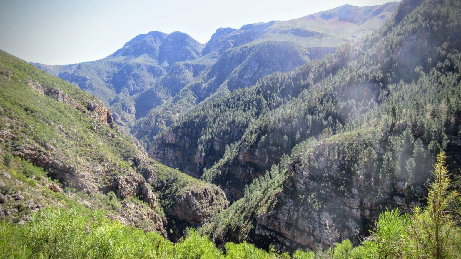
There were lovely views back over Greyton and the surrounding countryside, and I particularly liked the forested mountainside across the steep valley from us, looking left in the direction of hiking.
We hadn’t seen any other hikers so far, but at the saddle about halfway through the hike we met two groups resting in the very limited shade. Here we had views over a gorgeous new valley and set off to start the descent.
A little while later we came to the ‘swimming pool’, a beautiful clear, cool water pool in one of the rivers. You can’t miss it. There is a small waterfall too. This was also popular with other hikers and wonderfully refreshing.
Continuing in the heat, but on the last stretch, we came to a small choice in the way. We took the lower route today, knowing that we’d take the upper route on the way back tomorrow. The lower route follows the valley further, near the river, among the proteas and birds. The upper route follows the section of track dynamited out of the cliff when they were planning to build a road back down to Greyton.
Die Galg
We stayed at Boesmanskloof Die Galg Accommodation (see Accommodation box for more details). It was a lovely little cottage. Surprisingly, especially given its small appearance on the outside, it did indeed have enough room for 9 people as stated on the website. There were only two of us though. One thing lacking was pots and pans; we had to improvise and cook everything in a big turkey dish.
History of Die Galg – the far point of Boesmanskloof Hike
Die Galg, meaning the gallows in Afrikaans, is the name of the place you hike to. It was created in 1862, with plots of land in the area sold to farmers. You can still see the remains of the old village in the area.
The idea of a road that directly linked McGregor to Greyton was put forward many times. It currently takes 2 hours to drive between them, and a straight route would have drastically shortened this. The road was partially begun, but in the end neither McGregor nor Greyton, though both lovely, turned out to be the most important places. The road never went ahead and the beauty of the valley was left unspoilt.
Day 2 of Boesmanskloof Hike
The evening light was beautiful and so was the next morning, when we woke up to clouds covering the McGregor valley to the north. It was still sunny, but thankfully slightly cooler than the day before. We took the upper route along the dynamited track before it led us down to rejoin the same path as the day before. After our not-so-early start, we walked quickly by the pool. We hoped to reach our car and Cape Town not too late.
The kilometres whizzed by, and before we knew it we were back at the car park in Greyton.
The Town of Greyton
Greyton is a small, cute town with a laid-back atmosphere. There are plenty of accommodation options* and places to eat. We didn’t stay in town but after returning from our cafe we ate a late lunch at a nice cafe, the Oak & Vigne (Tripadvisor Reviews*). There is also a local brewery in town (Website or Tripadvisor Reviews*) making delicious craft beers, open every day apart from Public Holidays (12-5 & 7-9:30).
Additionally, there is a popular market every Saturday morning, 10 – 12, in the centre of the small town. It sells local produce such as cheese, yoghurt and dried fruit, baked goods and also arts and crafts.
Just over two hours later we were back in Cape Town, and stopped off at Spar to get a couple of beers to drink in the pool at home to cool and clean off after our lovely weekend. Little did we expect that this would not occur. We arrived back to find that people had broken into our house and stolen all our valuable stuff.
Make sure you don’t leave your house vulnerable when you are away!
If you like overnight hikes, try the Arangieskop Overnight Hike, Grootvadersbosch & Boosmansbos Overnight Hike, or a 4 Day Hike in the Cederberg. Additionally, find more hikes elsewhere in South Africa.
Related Posts


