By Tom · Published Oct. 3rd, 2021 · Updated Nov. 24th, 2022
When you buy through links highlighted with an asterisk (*) on this site, we may earn a small affiliate commission at no cost to you.
The Italian cross stands on an iconic peak overlooking Paarl and its surroundings. To get there, you follow the Miaspoort trail up a steep but stunning ravine from the Du Toitskloof Pass.

Location
This hike starts at a car park on the Paarl side of the Du Toitskloof pass. The nearest town is Paarl and it is 50 minutes and 70 km drive from the centre of Cape Town. If you don’t have a car, check out the options for car hire* from Cape Town.
Miaspoort Trail & Italian Cross Hiking Map
Get the route by downloading the .gpx or .kml file below. For navigation with Maps.me on your mobile phone, simply download the .kml file and open to add it to the Maps.me bookmarks.
Note: We gave this hike a difficulty rating of 4/5 because the first part of the trail is steep with some loose rocks and big boulders to cross.
Note 2: There is a permit fee of ZAR 50 per person, which we got via the online booking system.
Tips on Miaspoort Trail
- Miaspoort Trail is part of the Cape Nature Limietberg Nature Reserve.
- Book your permit online through Cape Nature, or get in contact with them.
- Permits are ZAR 50 p.p. for adults and ZAR 30 for children.
- Bring a sunhat, sunscreen and plenty of water. It can be very hot in summer.
- Start early for shade in the ravine, where the majority of the uphill is.
- The first part of the route is not marked very well, try and spot the yellow footprint markers.
- Offline maps app Maps.me may help with navigation.
- After the hike, enjoy a stroll and tasting at one of the nearby wineries. Check out our Cape Winelands Highlights for tips and a summary of other hikes in the region.
We left early from Helshoogte near Stellenbosch on a Friday morning in March 2021 and started hiking at 9:00 am. The car park is just a viewpoint along the road, and you need to walk along the road for 200 meters to the trailhead at the bottom of the ravine. The Miaspoort Trail starts where the metal barrier ends.
Miaspoort Ravine
The ravine looks rather impressive from the bottom. The first section of the climb is to the right of the stream and at some point, you cross the stream and continue on the left-hand side. The trail is highlighted by yellow footprint markers on some rocks, although they are not always very obvious.
Close to the start of the hike, you need to cross a boulder field. The route is not very obvious but basically you go straight across. Some very curious dassies live here.
Pay attention and cross the stream 300 meters after the boulder field. The stream crossing is covered by bushes and trees so is not very obvious. We missed this crossing and continued on the right-hand side of the stream for too long and had to retrace our steps.
After crossing the stream, the really steep part of the trail starts, basically until you reach the saddle at the top of the ravine.
The Saddle
We made our way up to the saddle in 55 minutes but you may take longer as Cape Nature estimates two hours for this part of the hike. After a break with enjoyable views of Du Toitskloof on the other side, we continued with the less steep part of the hike.
This section of the hike is definitely more enjoyable as the path is less steep and even flat or downhill in places and the views of the surrounding mountains and valleys are quite stunning. A highlight is the sight of the impressive Du Toits peak. However, a drawback is the noise from the N1.
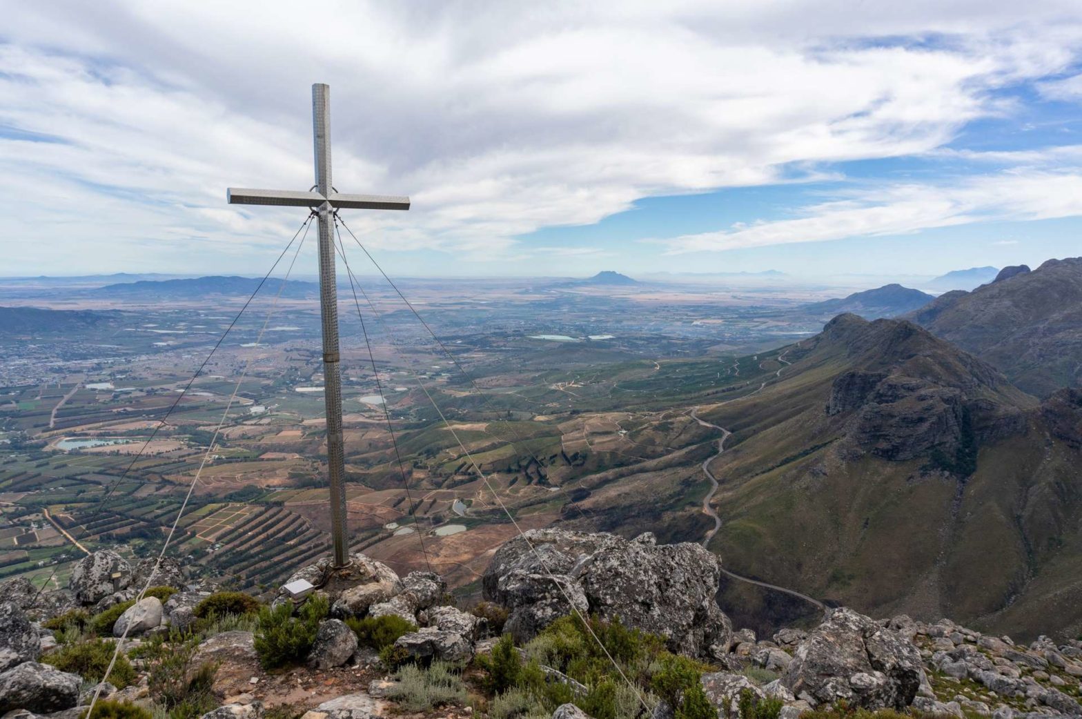
The Italian Cross
After crossing a little valley, you ascend onto a rocky promontory. The top of this is the Huguenot Peak with an elevation of 1318 meters. The trail continues just past the top towards the end of the promontory, where the Italian cross is.
The views from here over the Paarl valley are rather good. For instance, you can see the Paarl Domes from here and if the weather is good, Table Mountain and Lion’s Head are in sight as well.
The cross was erected in February 1945 by Italian Prisoners-of-war who built the Du Toitskloof pass. Next to the cross, there is a box with a register to sign and leave a note.
After enjoying the views, we retraced our steps to the car. The Miaspoort ravine was definitely less shady on the way down, so start early to avoid the hot sun. It’s quite steep and far on the way down, so hiking poles* are a good idea to save your knees.
For a summary of hikes in the region plus other activities, check out our Cape Winelands guide, or discover hikes elsewhere in South Africa.
FAQs about Miaspoort Trail
It is not an easy trail as it is steep in places and there are some loose rocks and big boulders to cross.
The Miaspoort Trail starts from the Du Toitskloof pass near Paarl and heads up to Huguenot Peak and the Italian Cross.
Yes, a permit from Cape Nature is required and costs ZAR 50 p.p. for adults and ZAR 30 for children.
The Italian cross is near the top of Huguenot Peak in the vicinity of Paarl.
The cross was erected in February 1945 by Italian prisoners of war who were constructing Du Toitskloof pass.
Huguenot peak reaches 1318 meters above sea level.
Related Posts


