By Tom · Published Dec. 12th, 2021 · Updated Nov. 28th, 2022
When you buy through links highlighted with an asterisk (*) on this site, we may earn a small affiliate commission at no cost to you.
Walking to the top of Bukit Timah Hill is a must in Singapore. This great hike combines the hill with the most beautiful section of the rail corridor through the natural Clementi Forest, and beyond to Holland Village.
Page Contents:
Location
This hike starts at Beauty World MRT stop on the blue downtown line. Alternatively, you can start at the Bukit Timah Nature Reserve Visitor Centre. The hike ends near Holland Village MRT or Buona Vista MRT. We did this walk on a Saturday morning in November 2021.
Bukit Timah Hill Hike Map
Get the route by downloading the .gpx or .kml file below. For navigation with Maps.me on your mobile phone, simply download the .kml file and open to add it to the Maps.me bookmarks.
Tips for Bukit Timah Hill and Clementi Forest
- Bukit Timah Nature Reserve is open from 7 am to 7 pm.
- There is shade from the trees for a large part of the hike, but some sections are open and sunny.
- Take a sun hat, sunscreen and plenty of water.
- Get some hiking poles* for the steep climb.
- For navigation, offline maps app Maps.me works quite well but not all trails on the map are open in reality.
We started our hike at Beauty World MRT station. Unlike the name, it is not a very beautiful area, but by taking one of the two overpasses you can quickly make it to the other side of the busy road where green jungle awaits you.

The route takes you underneath a bridge of the rail corridor and continues to Bukit Timah Nature Reserve Visitors Centre. Here the climb to the top of the hill starts, on a very steep paved road. It is quite a popular path.
After a while, at Simpang Hut, we took a left turn to the Telecom tower and left the crowds behind. From the top of this out-and-back path you can vaguely see the Hindhede quarry lake through the trees.
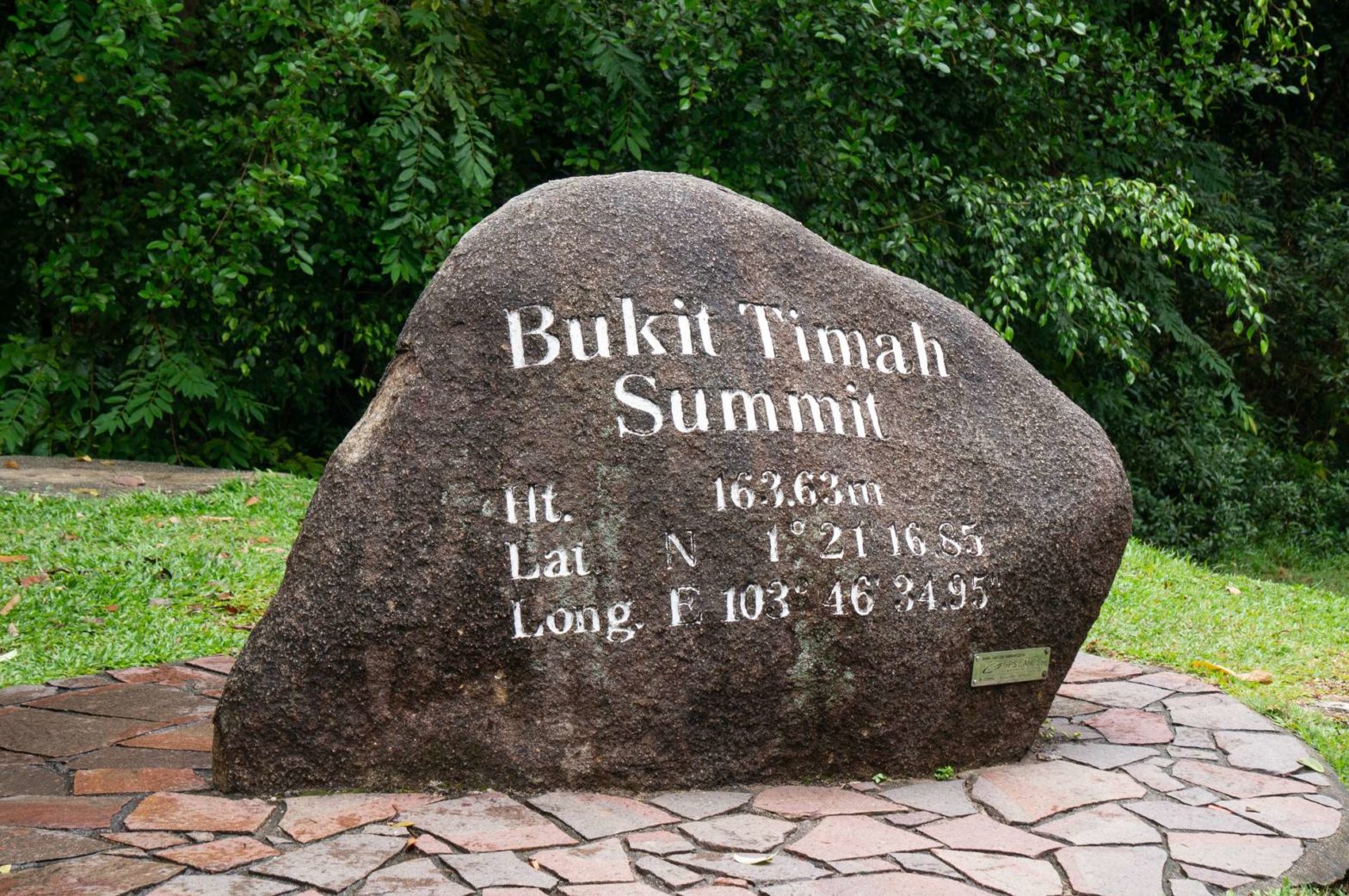
Bukit Timah Hill
After this quick detour to the Telecom tower, we joined the main path again and headed up the steps on the right. These steps take you to the summit of Bukit Timah Hill. A big boulder marks the summit (more or less) and some benches under the shelter provide a nice spot to recover from the steep uphill slog.
A little away from the top, a path branches off to the right to the Dairy Farm Loop. Unfortunately, the Dairy Farm Loop is closed at the moment (Dec 2021) due to landslides, but the smaller Jungle Falls Path Loop is initially in the same direction. This loop is unpaved except for the stairs and wooden structures that cover the path from time to time. Unfortunately, the waterfall the path is named after is not impressive.
The Jungle Falls Path takes you back to the main path. We descended back to Simpang Hut and a little further took a path to the right. We were headed for the Cave Path. There are indeed some (fenced) caves along the path. And to complete all paths here, we took the Taban Loop and eventually made it back to the visitors’ centre.
Which Backpack to Bring
You don’t need a very big backpack for hikes like this one in Singapore. There is no need to carry many extra clothes, and you will basically use it only for food and drinks, rain jacket* or umbrella*, sunscreen, phone and wallet, and potentially a pair of binoculars* or extra lenses for your camera. A rain cover* is very useful in the heavy downpours of Singapore if your backpack doesn’t come with one. We often share a backpack between us. Any comfortable day pack suffices, like a great Osprey day pack:
Osprey Men’s Talon 22 Hiking Backpack on Amazon*.

Check out the complete list of hiking gear needed for Singapore:
Hindhede Nature Park
From the Bukit Timah Visitor Centre, it is only a short stroll to the viewpoint of the Hindhede Quarry Lake. It is quite beautiful due to the rocky cliffs and their reflections on the water, an unexpected sight in Singapore. From there you wind your way back to the main road again, this time heading onto the Rail Corridor.
Rail Corridor
The Rail Corridor is a 24km stretch of former railway that connected Tanjong Pagar Railway Station in the South to Woodlands in the North. The majority of the 24km is converted into a foot- and cycle path, and the remainder is being converted and upgraded as we speak. The Rail Corridor passes Bukit Timah and so we hopped on and walked South.
Clementi Forest
The most beautiful section of the Rail Corridor, in our opinion, is the part that crosses through Clementi Forest. You enter the forest about 1.5 kilometres from Bukit Timah.
The rainforest of Bukit Timah Hill can be a bit oppressive since you don’t have any views. Clementi Forest around the Rail Corridor is open and spacious and you see all the impressive trees and treetops. There are many interesting birds flying from tree to tree and no noisy traffic to distract from the serene environment.
There is a big canal crossing the Rail Corridor in Clementi Forest. To the left there is a huge concrete basin while to the right there is a grassy canal to take away the heavy downpours that often happen in Singapore.
We continued on the Rail Corridor all the way to Holland Village. There we took a little path and bridge to the left to leave the Rail Corridor and made our way over to the centre of Holland Village for a delicious Roti Prata at Cafe O. There are many other eateries and a hawker centre, so plenty of choice. We went home via the Holland Village MRT station.
Alternatively, you can walk slightly further on the Rail Corridor and turn right to Buona Vista MRT station.
Guidebooks to explore more of Singapore


Another good hike to explore the interior rainforest is MacRitchie Reservoir Hike. For another hike with a lot of climb, go and explore The Southern Ridges. For more hikes, check out our Singapore Hiking Guide.
FAQs: Bukit Timah and Clementi Forest
Bukit Timah is open from 7 am to 7 pm.
The Rail Corridor is 24km in length, going from Tanjong Pagar in the South of Singapore to Woodlands in the North.
Bukit Timah is a hill reaching 164m above sea level. It is the highest natural point in Singapore.
Related Posts


