By Vicky · Published Mar. 6th, 2022 · Updated Sep. 3rd, 2023
When you buy through links highlighted with an asterisk (*) on this site, we may earn a small affiliate commission at no cost to you.
Explore Singapore’s South East Coast on this coastal walk by the water from Changi Beach Park to Changi Bay Point while admiring birds and Malaysian Islands.
Changi Beach Park & Bay Point Hiking Map
Get the route by downloading the .gpx or .kml file below. For navigation with Maps.me on your mobile phone, simply download the .kml file and open to add it to the Maps.me bookmarks.
Page Contents:
Location
This coastal walk starts from Changi Village Bus Terminal. Take a bus there from Tampines East MRT station on the blue Downtown Line. The walk ends at Opp SAF Ferry Bus Stop, roughly 1.5 km to the east of Changi Village Bus Terminal. From here you can take buses back to the MRT station or elsewhere. Or, walk another 1.5 km to return to Changi Village Bus Terminal and the Hawker Centre next door.
Tips for Changi Coastal Walk
- Changi Beach Park and Changi Bay Point are both open 24/7 and lit between 7pm and 7am.
- Swimming at the beach is allowed but the water is slightly dirty and there is often a lot of trash. Crocodiles are occasionally sighted.
- Take a sunhat, sunglasses and sunscreen as it’s easy to get burnt when walking along the beach.
- Changi Village Hawker Centre is just next to the Bus Terminal.
- Check out other great hikes on our Singapore Hiking Page
From the bus stop in Changi Village Bus Terminal, we first walked around the neighbouring hawker centre and left towards Changi Point Bridge.
Changi Beach Park
The bridge leads across the still water into Changi Beach Park. To the left, you can see the ferry terminal with all the little boats waiting to go to Pulau Ubin.
Once across the bridge, head left to walk around the outside of Changi Beach Park, right next to the water. At low tide, there will be much more sand and a more extensive beach than at high tide. At the end of the park, there is a sculpture of a giant hand, with the beach, sea and Pulau Ubin in the distance.
Bend right to continue walking along the beach. Keep an eye out for birds – there are often white cockatoos and large Oriental Pied Hornbills swooping low. This park is popular with fishermen, and you may have to duck to avoid their lines strung into the water. Families also enjoy visiting this park for a picnic underneath the trees.
See Birds up Close with Binoculars
To see all the nice birds on this hike up close, get a decent pair of binoculars. I have had a pair of Bresser binoculars* for over 20 years now and they are pretty indestructible and work well. Another well-reviewed pair on Amazon are these Celestrons:
Celestron Nature DX 8×42 Binoculars on Amazon*.
Check out the complete list of hiking gear needed for Singapore:
It’s possible to swim in the water here, though it’s a bit dirty and there is quite a lot of trash littering the beaches in Changi Beach Park.
Changi Coastal Track
As you approach a jetty, the park narrows and you continue by the water on the Changi Coastal Track. Roughly 500 metres later, the park starts again. The park is narrower here and you can choose to either walk along the Coastal Track – a paved track in the trees, or along the beach itself. However, if it’s high tide, the beach becomes very narrow.
The coast here is very nice as it’s lined with many trees with more of a wilderness feel than the first section of Changi Beach Park. On your left, you can see across the ocean to the islands of Singapore and Malaysia. After a bit over 1 kilometre, you’ll reach some barbecue areas and the end of Changi Beach Park. Head towards the road and you’ll reach a Park Connector leading to Changi Bay Point.
Find more Fun Outdoor Activities in Singapore!
- Visit the Domes* at Gardens by the Bay
- See the animals at Singapore Zoo*
- Explore historic Singapore by Bike*
- Cycle around Pulau Ubin*
Changi Bay Point
This park has been very popular since it opened in January 2022. The Park Connector first leads alongside a road before cutting back to the coastline. The track is tarred and very wide, allowing groups of cyclists and pedestrians to pass both ways.
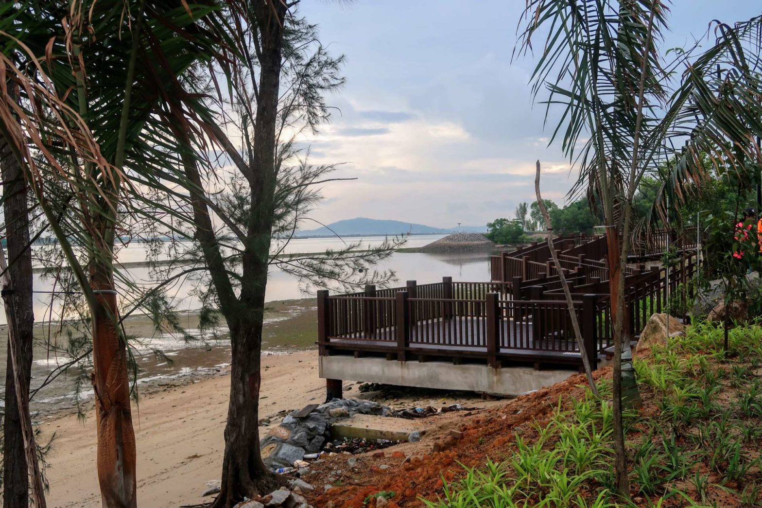
It can look quite different here between low and high tide. The beaches are much larger at low tide and almost disappear when the tide is high. Whenever you go, there’s a lot of trash around the path here and on the beaches. There are several nice benches dotted along the route where you can sit and admire the trash.
At Changi Point itself, there’s a raised wooden walkway from where there are views across to Malaysia and over a sandy bay on the Singapore shoreline. Roughly 500 metres further there’s another boardwalk over the beach or ocean, depending on the tide. Just behind the short section of the boardwalk is a toilet block.
Heading Back
This boardwalk is the far point of the hike and you should now return the same way you came. If you continue, you have to walk a long way (10.5 km) next to a road without any views until you reach the next bus stop at Tanah Merah Ferry Terminal.
On your return, you can walk some slightly different trails through Changi Beach Park. The first bus stop you reach that has buses on weekends is Opp SAF Ferry Bus Stop, roughly 1.5 km to the east of Changi Village Bus Terminal. You can either take the bus from here or continue walking another 1.5 km to return to Changi Village Bus Terminal. There is a hawker centre here to refuel after your hike.
Want to see more of the East Coast of Singapore? Check out our hiking trails in Pasir Ris or Coney Island. For other hiking ideas check out our Singapore Hiking page.
FAQs for Changi Beach Park to Bay Point Walk
Changi Beach Park is open daily 24/7 and lit between 7pm and 7am.
There are several barbeque areas in Changi Beach Park. Book on the government website.
To get to Changi Bay Point, take the bus from to either Changi Village Bus Terminal or SAF Ferry Bus Stop. Several buses head here from Tampines East MRT station. You then have to walk 5 km from Changi Village or 3.3 km from SAF Ferry Bus Stop to reach Changi Bay Point. Then you must return the same way.
The easiest way to reach Changi Beach Park is to get the bus from Tampines East MRT station (on the blue Downtown Line) to Changi Village Bus Terminal.
There’s loads of trash lying around Changi Bay Point Park, it’s not clean at all.
You are allowed to go swimming in Changi Beach Park but there’s lots of trash and the water is not very clean. Occasionally there are also crocodiles in the water.
Changi Bay Point is open daily 24/7 and lit between 7pm and 7am.
Overnight camping is not allowed in Changi Beach Park, but lots of people use tents as shelters from the sun and rain or as a place to lie down during the daytime.


Thank you for your introduction do I need to pay for subscription?
Hi Veronica, I’m glad you liked the write-up. It’s a free website, so there is no need to pay for subscription. 🙂
Very interesting write up. I am very keen to walk around/visit places you recommended.
I’m sure you meant to say, we can see Malaysia from Changi. It’s not possible to see Indonesia from that point in Singapore.
thanks for pointing that out!! 🙂