By Vicky · Published Mar. 20th, 2022 · Updated Nov. 29th, 2022
When you buy through links highlighted with an asterisk (*) on this site, we may earn a small affiliate commission at no cost to you.
A Pulau Ubin Hike is one of the best walks in Singapore because it feels like you’ve travelled back in time to a laid-back kampong culture surrounded by beautiful nature.
Pulau Ubin Walking Trail Map
Get the route by downloading the .gpx or .kml file below. For navigation with Maps.me on your mobile phone, simply download the .kml file and open to add it to the Maps.me bookmarks.
Page Contents:
How to get to Pulau Ubin
Pulau Ubin is an island off the east coast of Singapore. To get to Pulau Ubin you first head to Changi Point Ferry Terminal. To get there take the blue Downtown line to Tampines East MRT station, or the green East-West line to Tanah Merah MRT station. There are buses from both of these MRT stops directly to Changi Village Bus Terminal where the Ferry Terminal is.
From the bus terminal walk roughly 150m to Changi Point Ferry Terminal. Enter from the top and head downstairs to join the queue for ferries to Pulau Ubin.

Ferry to Pulau Ubin
From the ferry terminal, bumboats (motorized boats) run from 7am until 6 or 7 pm daily, leaving when there are enough passengers (normally 10-12 people). Normally the wait is from just a few minutes, up to 15 minutes. The $4 fee per person each way is paid onboard and it’s a little extra ($2) for a bike – make sure you have cash. The boat crossing itself takes about 10-15 minutes. If you miss the last boat back you call the Singapore National Parks hotline on 1800 471 7300 for help.
Tips for Pulau Ubin
- There are no ATMs on the island and cards are not accepted so bring enough cash. The Changi Village Hawker Centre (by the Bus Terminal) has ATMs (OCBC and POSB).
- Check out the tide timetable for Singapore and plan to reach Chek Jawa wetlands around low tide.
- Bring lots of water – there is no drinking water on the island, though you can buy some in the shops in the Main Village.
- Sunscreen, sunhat and sunglasses are highly recommended.
- Bring a rain jacket or umbrella as the weather can change quickly.
- Watch out for the wild boars and aggressive monkeys!
- Download the Maps.Me App beforehand – there is not phone signal everywhere on the island so it’s good to have a backup map.
- Check out other great hikes on our Singapore Hiking Page
Pulau Ubin Overview
Jungle covers Pulau Ubin, with some scattered wooden houses throughout. Main Village, by the Boat Jetty, has a concentration of restaurants, cafes and bike rental places. At the eastern end of the island is Chek Jawa Wetlands, the highlight of any trip to Pulau Ubin. Towards the west is the famous Ubin Quarry Viewpoint from Puaka Hill, with Ketam Mountain Bike Park further on.
Top Activities on Pulau Ubin
- Chek Jawa Wetlands
- Visitor Centre aka House No 1
- Puaka Hill Hike to Ubin Quarry Viewpoint
- Kayak through the mangroves*
- Butterfly Hill Overlook of Pekan Quarry
- Wei Tuo Fa Gong Temple
- Go on a Bike Tour of the Island*
Cycle or Walk on Pulau Ubin?
Cycling is easier and most of the roads are paved so you will zoom along. However, you may miss the special sightings you only have going at a slower pace, such as wild boar, pretty flowers or sunlight beams streaming through the jungle. A large section of the route to Chek Jawa Wetlands is on a gravel track with some ups and downs.
You can’t cycle around the wetlands themselves, you must walk this bit but can leave your bike at the large bike park just outside the entrance. You also can’t cycle up Puaka Hill, but again there’s a lot of space to leave your bike at the bottom of the muddy single-track climb to the quarry lookout point. The Sensory Trail is also walking only, and it’s fairly nice. But walking can get very tiring – if you don’t walk a lot then biking is a great way to get around.
If you walk around Pulau Ubin expect to be on the island for most of the day. We walked almost 20 km to see everything we wanted to on the island. Sometimes when walking along the flat paved tracks we were jealous of the bikes, but then we enjoyed the routes where bikes couldn’t go because it was very quiet. If you walk, get there as early as possible (ideally be at the ferry terminal at Changi before 8am, the closer to 7am the better).
If you want to see the key sights while not walking so far, try a guided half-day trip to Pulau Ubin*, and a van will shuttle you about. Kayaking* is another great way to explore the island from a different perspective.
Bike Hire on Pulau Ubin
Many shops in Main Village on Pulau Ubin rent out bicycles. It’s roughly $10 per day for a normal bike. You can also reserve a bike online*. Make sure to check it works fine before riding away. Fancier bikes are available, and you can get baby seats or mountain bikes if you want. The bikes cost the same at every place so there’s no need to shop around.
Pulau Ubin Hiking Route
This Hiking Route takes in all the top activities in Pulau Ubin mentioned above. The route first heads east from the Boat Jetty to Chek Jawa Wetlands via the Sensory Trail, then returns back and continues west via Puaka Hill to the German Girl Shrine and a viewpoint over Ketam Quarry in the bike park. The walk then finishes by returning to Pekan Quarry, the Main Village and the Boat Jetty.
The Sensory Trail
Head off the boat and turn right to walk along the Sensory Trail. If you decide to hire a bike instead of walk, you must instead turn left to the many bike hire shops, continue through the village and head right to meet up with the Sensory Trail where at the far end of the Sensory Trail Pond.
If walking, a short distance from the boats you’ll see a small red shrine (Mazu Altar) on your right. On your left is the Nature Gallery that you can return to later at the end of your trip. The Sensory Trail continues for about 1.5 km through jungle and gardens. You can see fruits, including pineapples, growing by the path and you also head through some peaceful jungle. This part of the trail is very nice because it’s not paved so few bikes come this way.
About 400 metres into the trail there is a junction. The path to the right leads to a secret, secluded beach with palm trees. After checking out the sand and the views, head back and continue on the path to bending round to the left. Soon you’ll reach the Sensory Trail Pond.
Sensory Trail Pond
This is a gorgeous, natural piece of water filled with lilies and surrounded by palm trees. Shortly after the pond, you reach the paved Jalan Ubin, often busy with bikes, and a typical Kampong house just opposite (you can just see the roof).
Teck Seng’s Place
Teck Seng’s Place is a traditional Chinese Kampong House that you can visit only a few days per month. It’s named after a shop owner, who moved to mainland Singapore in 2005 and the government took over the house. It’s now furnished as it would have been in the 1970s so you can get an idea of what life used to be like on the island.
Walking along Jalan Ubin
Head right at the house along Jalan Ubin. You’ll soon meet a road junction – continue straight on. Here on your left is one of my favourite houses on the island, with a gorgeous balcony partially hidden by the wonderful tropical foliage.
Roughly 300 metres later you’ll see Ubin Fruit Orchard on your left. There are many fruit trees here but it’s hard to see any fruits and it’s not particularly interesting. Not much further is a collection of kampong houses around the road, mainly on your right in a cleared bit of jungle. The last of these houses is Warung Pak Ahmad, a cute family cafe selling drinks (opens at 9 am).
Just after the cafe is a junction. Follow the signposts to Chek Jawa Wetlands by turning right along Jalan Durian.
Walking along Jalan Durian
Roughly 500 metres after the junction, you’ll reach another junction. Again there are signs, so follow them to Chek Jawa. The paved road ends here and becomes a gravel trail with some undulations. It’s a nice path, surrounded by dense jungle on either side. We saw loads of monkeys, a few roaming wild boars and the beautiful morning sunlight streaking through the trees to light up the dense under-canopy.
Common Pulai Heritage Tree
A particular tree of note, and one you can’t miss, is a very tall tree on the left of the path. It’s a Common Pulai tree more than 100 years old and is over 40 metres high. Common Pulai trees grow in Peninsular Malaysia as well as elsewhere in Singapore.
Not too much further, and roughly 4 kilometres from the Ferry Jetty, you reach the main highlight of Pulau Ubin. You can cycle all the way up to this point, but must now dismount and park your bike.
Chek Jawa Wetlands
Chek Jawa Wetlands is a must-see area of Pulau Ubin. The wetlands are a unique ecological niche and provide a habitat for many diverse creatures. The area is open 9am-5pm, but it’s best to visit around low tide (check out the tide timetable for Singapore) and when it’s sunny. Cycling is not allowed so there’s a large bike park just outside the entrance.
Not far from the entrance there’s a path junction and a small shelter with some information boards. If you are interested in a guided tour of this area, NParks leads guided tours of Chek Jawa that coincide with low tide.
Chek Jawa Boardwalk
We first headed straight on to the Chek Jawa Trail and the boardwalk over the sea. It’s just out from the coast so you can see the rocky shoreline covered by coastal forest. The headland is made of granite, and the plants have to be tough to cope with the salty sea spray, strong winds and shallow soils. This environment used to be common in Singapore, but development means no longer. We were lucky enough to see a huge, shaggy-coated wild boar snuffling around on the beach before he retreated back into the dark of the jungle.
Near the end of the boardwalk, when we approached the beach, we saw many fiddler crabs scuttling about between some tall, mystical-looking roots. One claw of these crabs is much larger than the other. It looks a bit awkward, but males use the large claw to wave over potential mates and fight against competitor males.
Chek Jawa Mangroves
Continue right along another section of boardwalk, which this time heads through a large mangrove forest. We saw many monkeys here, eating the crabs and playing in the mangrove roots.
You’ll also notice extraordinary building works, mountains of mud, built again by a type of crab. In places the mud looks almost like man-made walls, but it’s the crabs that have made these fantastic structures to have a nice home even when the tide comes in and the surroundings are covered in water.
Jejawi Tower
The trail heads more inland and round to Jejawi Lookout Tower. It’s a high tower with views over the Straits of Singapore, Malaysia and the surrounding jungle. It’s named after the Jejawi Tree, or Malayan Banyan, which is just behind and even taller than the tower. Take binoculars and you might see Bhramini Kites or White-bellied Fish Eagles.
After the tower, continue along through the jungle then head left back to the junction and small shelter. If you head straight across you will reach House No. 1 and a lookout jetty.
House No. 1
House No. 1 is a historical bungalow, built in the 1930s as a weekend retreat and now the Check Jawa Visitor Centre. There are also useful bathrooms here in the outhouse. Inside the visitor centre are a few small exhibits about the island’s flora and fauna and the restoration of the wetlands, but the main highlight is the architecture of the house itself.
The building is a Tropical Tudor-style black and white house, restored in 2003. It’s a lovely setting, with views over the sandy shores of Changi Point, opposite it on the mainland and jungle on either side. And the house would remain cosy in bad weather since there’s even a fireplace! It’s called House No. 1 because that’s the postal address on Pulau Ubin for this house, where street names aren’t really used.
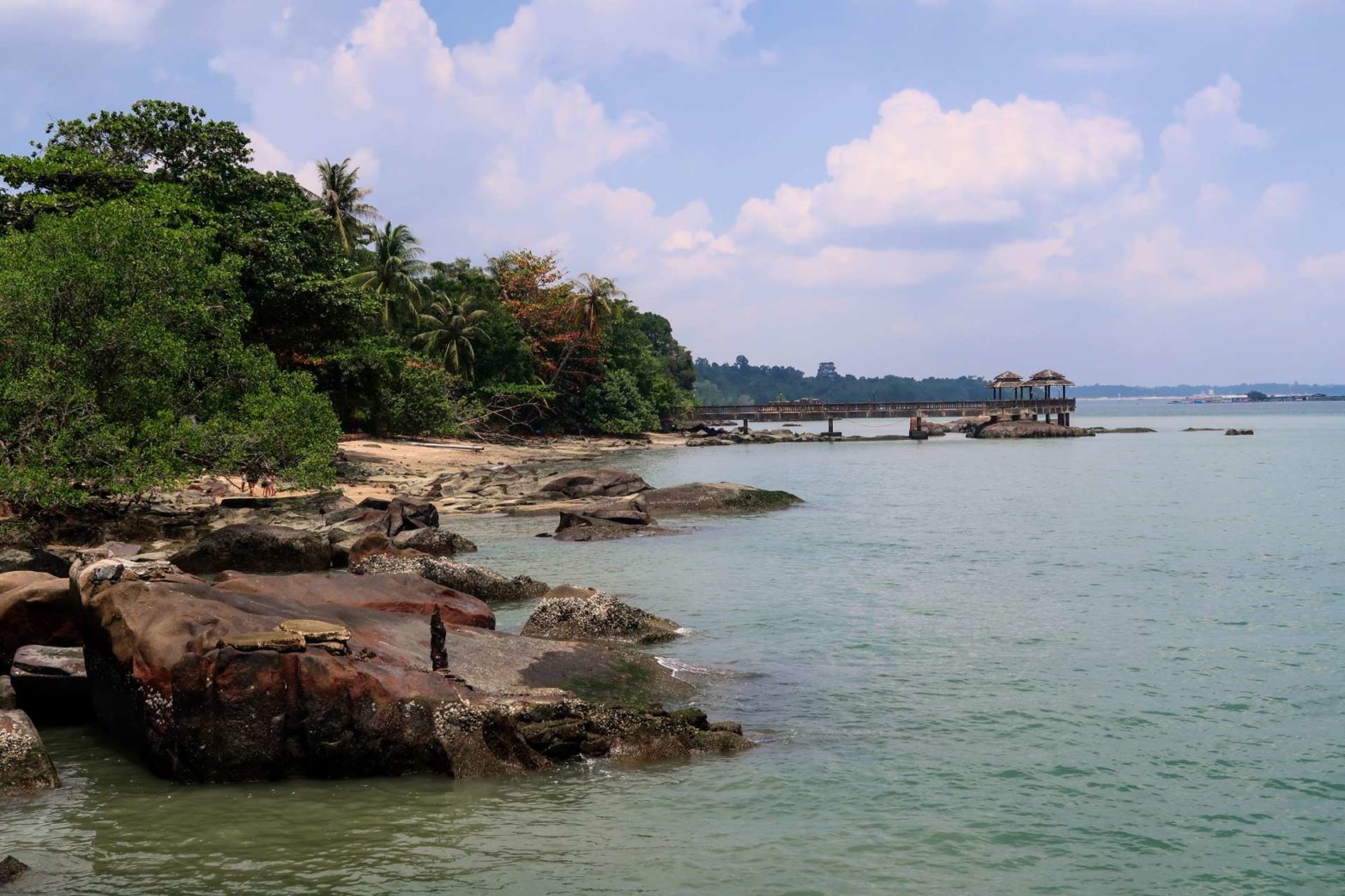
Viewing Jetty
In front of the Tudor-style house is a viewing jetty. If you walk to the end you get good views of Pulau Sekudu (Frog Island), the little rocky and sandy island. Looking back the other way you can see the coastal forest of Pulau Ubin stretching into the distance and the lovely house amidst the sandy coves and jungle.
Return back to the junction and out of Chek Jawa Wetlands. Head back the same way you came (the former path back is now closed until further notice). If you want to vary the route on the way back and walk on a secluded trail, take the Muslim Cemetery Loop.
Muslim Cemetery Loop
This loop through the jungle has very few visitors. The entrance is easy to miss – it’s just after a bridge on your left and is not signed. You can see several Muslim graves scattered throughout the jungle, along with some sandy bays along the coastline. It’s about 400 metres further than the straight route, which join together again where the paved road starts.
Retrace your steps along Jalan Durian and Jalan Ubin (with a potential drink stop at Warung Pak Ahmad) until the road junction with Jalan Batu Ubin just after the nice house. This road is easy to spot because it heads uphill, unlike all the other flat roads.
Jalan Batu Ubin
Walk uphill on this quiet road. Soon you’ll see a sign to the Chinese Cemetery. This is a very short out-and-back detour to see some large, typical Chinese graves in the jungle.
After the cemetery, you’ll see the fence of Pekan Quarry. Before walking around this, head right on Jalan Jelutong to explore the west of the island.
History of Pulau Ubin
Prawn farming and quarrying were the main industries on Pulau Ubin in the 1950s to 1970s. More and more prawn farms sprung up in the lagoons of the island. Dams were built between the lagoons to control water levels, and you can see many of these today. The Pulau Ubin Quarries also employed many local people and the population hovered around 2,000.
Today quarrying has ended and only roughly 40 people still live on the island, mainly working in the tourism industry.
Jalan Jelutong and West Pulau Ubin
This route is a paved road through the jungle. The first place of note is Ah Ma Drink Stall (open 9am-5pm), 450 metres from the junction. This little shop, run by a mother and daughter team, is a bit of an institution and sells fresh coconut juice, soft drinks and fruit. The stall was renovated in 2018 in kampong style, it’s very cute. You can learn about the clever roof construction and much more from the posters on the wall.
Continuing along the road, the next point of interest in Wei Tuo Fa Gong Temple, 250 metres down a side road to the right. There are several temple buildings here, and many many prayer flags hanging over a lake. There’s a cute bridge, buddha statues, colourful roofs and a general sense of calm. It’s worth the short detour.
A short distance further along the main road is another turnoff, this time to Puaka Hill and the famous Ubin Quarry Viewpoint at the top.
Puaka Hill
The path up Puaka Hill is quite steep, narrow and a bit rocky. There’s a bike parking at the bottom for those who are cycling. It takes about 10-15 minutes to reach the top viewpoint and slightly less on the way down. About halfway up is another similar viewpoint over Ubin Quarry. You can see the clear dark blue water and jungle behind. We were lucky enough to see a pair of Brahmini Kites circling on the other side of the water.
Quarries on Pulau Ubin
There used to be five granite quarries on the island: Ketam Quarry (now in the bike park to the north), Pekan Quarry (near the Village, with herons), Ubin Quarry (climb Puaka Hill for the viewpoint), Balai Quarry (northeast of the island, currently inaccessible) and Kekek Quarry (north of Ketam Quarry, unvisitable). There’s not much granite rock elsewhere in Singapore, which is why there are so many quarries on the island.
Blast-quarrying was the technique used to remove the rock. This method involved drilling deep cylindrical holes into the granite and stuffing them with explosives. You can still see evidence of these blast holes in the large rock at the viewpoint on top of Puaka Hill. The fractured, small pieces of rock were then shipped on barges to the mainland.
From the top viewpoint, the view is slightly better as you can see further over the island and all the way to Malaysia. There are some railings here (and at the other viewpoint) that are slightly too far back from the cliff edge to get a great photo. It used to be easy to get around the side of the railings but now this has been blocked off too and there are many signs warning you not to climb over the railings.
Shortcut: If you are tired and want to head back to the Main Village now, this is a good turnaround point as you’ve seen the main sights of Pulau Ubin. You’ll miss 5km, so the entire walk will be about 14 km instead of 19 km.
Continuing to Western Pulau Ubin
To continue on this walking trail, continue west along the road. Soon you’ll see Na Du Gong Shrine, in a small yellow tin building on the right. This is a shrine to a local guardian spirit, commonly worshipped by overseas Chinese communities.
Around the bend in the road you’ll come to the Ubin Living Lab and Ubin Water Pond. There are some nice benches in the shade of palm trees overlooking the water, a great spot for lunch, as well as bathrooms here. Walking around the pond is a nice, short loop and it feels very peaceful.
Just after the pond there is a short out-and-back grassy track that leads to another Ubin Quarry Viewpoint. Since you’re now at the water’s edge you get a different perspective from the viewpoint on top of Puaka Hill.
Back on the main road, you’ll see Kiu Tao Dua Pei Gong, another small temple, just before a bridge over some water. The bike park starts a few hundred metres down the road.
Ketam Mountain Bike Park
The Ketam Mountain Bike Park is extra nice because there are no cars here and the tracks are not paved. It’s very peaceful and calm walking around among the grass and trees in this area. There are two main points of interest here, the German Girl Shrine and Ketam Quarry Viewpoint.
German Girl Shrine
To reach the German Girl Shrine, head left at the junction after entering the park. The shrine is not too far along here and is signposted to the left of the main track.
The shrine is named after a German Girl who fled at the start of the First World War. Her parents were rounded up by the British, but she managed to escape and reach Pulau Ubin. Unfortunately, she died anyway when she fell into a quarry. Local plantation workers found her body and gave her a respectful burial. Although the girl was Catholic, once dead she morphed into a local Taoist Deity, worshipped for health and luck. The shrine itself is slightly eerie but has a lovely setting amongst the trees.
Ketam Quarry Viewpoint
After the shrine, head back to the main track and continue. The first right is a short out-and-back to Ketam Quarry Viewpoint. There’s not much shade here, but there’s a nice view over yet another quarry. It’s surrounded by cliffs and jungle, and again there’s a good chance of spotting Sea Eagles or Brahmini Kites here.
This is the far western point of the walking trail, so after admiring the view, head all the way back through the bike park, along the road and to Pekan Quarry.
Pekan Quarry
When you reach the junction by the quarry, head right. Pekan Quarry is an old granite quarry, now filled with water to create a picturesque lake. There are many herons and other birds, such as Oriental Pied Hornbills, that frequent the area. It’s a nice place for sunset if you are here late – but don’t miss the ferry back!
Pekan Quarry Lookout Point is by the edge of the water, but you can get perhaps better views from the top of Butterfly Hill. To get there, head right on a small little path just after the large wooden sign for Butterfly Hill, just after the lookout point. You’ll walk through some trees and end up at the Pavillion at the top of a small here. You get great views from here across the lake, framed by jungle greenery.
See Birds up Close with Binoculars
To see all the nice birds on this hike up close, get a decent pair of binoculars. I have had a pair of Bresser binoculars* for over 20 years now and they are pretty indestructible and work well. Another well-reviewed pair on Amazon are these Celestrons:

Celestron Nature DX 8×42 Binoculars on Amazon*.
Check out the complete list of hiking gear needed for Singapore:
Walk down the paved path to the base of the hill. The plants here have been specifically chosen to attract butterflies, so keep your eyes peeled! Head left at the main track and you’ll reach the outskirts of Pulau Ubin Main Village.
Pulau Ubin Main Village
There’s an interesting temple in the village, split into two parts. The uphill section of Fo Shan Ting Da Bo Gong Temple is on the western side of the village near where you enter. There’s a painted wooden sign and prayer flag to guide you down a little alleyway to the temple. The other part of the temple is in the centre of the village, opposite the Wayang (traditional puppet theatre) Stage. Festivities still take place at both of these sites.
Food and Beverages in Main Village
In the centre of the Main Village are several restaurants, drinks stalls, and many bike rental places. We got an ice-cold coke and sat on the beach near the boat jetty, watching the rhythm of the waves.
The two main restaurants of note are Cheong Lian Yuen Coffee Shop and Season Live Seafood. Cheong Lian Yuen Coffee Shop is only open on the weekends, while Season Live Seafood is open every day except Tuesdays.
Returning to the Mainland
When you’re refreshed and ready, continue to the Boat Jetty to take a bumboat back to the mainland. The process is the same as on the other side, you wait until there are 12 people and then board a boat. In the middle of the day this stretch of water is quite busy with an assorted array of boats, if you’re not too tired, check out the action.
After disembarking, the bus stop at Changi Village Bus Terminal is only a hundred metres away.
Birds and Wildlife while hiking on Pulau Ubin
Pulau Ubin is a great place to see wildlife. Birds you might see include herons, white egrets, wading birds and kingfishers (in Pekan Quarry and Chek Jawa wetlands), Pied Oriental Hornbills (especially around Pekan Quarry), White-bellied Sea Eagles and Brahmini Kites (often seen flying over the quarries or coastline). Asian glossy starlings, with bright red eyes, fly about near the Boat Jetty and Jejawi Tower, while straw-headed bulbuls can be distinguished by their reddish head and brown-and-white streaked chest. Bring binoculars if you have them!
There are a large number of monkeys on Pulau Ubin Island, they’re hard to miss. Wild boars are also fairly common if you walk quietly so as not to scare them away. If you’re there at low tide, you can see many crabs in Chek Jawa Wetlands.
Campsites on Pulau Ubin
If you want to stay the night, there are three campsites on Pulau Ubin: Jelutong (just west of the Main Village), Endut Senin (2 km west of the Main Village, by Ubin Water Pond) and Mamam (2 km north of the Main Village, on the northern coast).
Mamam Campsite is the most remote and has views across to Malaysia, while Jelutong Campsite is nearest the Boat Jetty and the only place you’re allowed to have a campfire. Endut Senin is on the edge of a cute pond, not at the ocean. The water at the campsites isn’t safe to drink so bring your own or boil the water available. You must apply for a camping permit to camp on Pulau Ubin, book on the AXS system.
Guidebooks to explore more of Singapore


Want to see more of Singapore? Check out the Southern Islands, Sentosa Island, or to explore the city, stroll around Marina Bay. For other hiking ideas check out our Singapore Hiking page.
FAQs for Pulau Ubin Walk
To get to Pulau Ubin you first need to reach Changi Point Ferry Terminal, from where bumboats head across to the island. The boats leave whenever there are 12 people, so you may have to wait a few minutes, but never too long. Pay $4 per person cash onboard each way. To get to the Ferry Terminal, take a bus from Tampines East or Tanah Merah MRT stations.
Pulau Ubin has no official opening hours because people live on the island so it’s fine to walk about anytime. However, the ferries from mainland Singapore only operate during daylight hours (roughly from 7am to 7pm), so you will only be able to arrive and leave the island during these times. You can camp on the island, and if so you’re free to wander around after dark (though remember to bring a light).
The best things to see on Pulau Ubin are the Chek Jawa Wetlands at low tide and the Ubin Quarry Viewpoint at the top of Puaka Hill
In the 1900s, Pulau Ubin was an important source of granite needed for construction in Singapore. Now, Pulau Ubin is an important area for tourism and one of the most beautiful Singaporean Islands.
Pulau means ‘island’ and Ubin means ‘granite’ in Malay, so Pulau Ubin means ‘Granite Island’. This is because the island is one of the best sources of granite rock in Singapore, and the many quarries reflect the importance of granite to Pulau Ubin.
It’s easy to rent a bike on Pulau Ubin, just head left from the Boat Jetty on arrival at the island and you’ll soon reach many shops renting bikes. They all have a fixed price per bike type so it doesn’t matter which shop you choose. Remember to check your bike works before you cycle away from the shop.
You are allowed to bring a dog to Pulau Ubin, but for the bumboat crossing it must be secured in a cage or a bag, else you will have to pay for the entire boat ($48). Dogs aren’t allowed in some parts of the island such as Chek Jawa Wetlands.
There is no set walking route on Pulau Ubin, but if you want to see Chek Jawa Wetlands and Ubin Quarry Viewpoint at the top of Puaka Hill, it is at least a 12-kilometre walk. The walking route described here visits more points of interest and heads further west, making it 19 kilometres.
You do not need a passport to visit Pulau Ubin from mainland Singapore, since Pulau Ubin is part of Singapore.
Roughly 40 people still live on Pulau Ubin, down from a peak of 2000 when the granite quarries were active. There is still a sense of community among the locals, who live more of a traditional kampong life than most people in Singpaore.
Related Posts


