By Vicky · Published Feb. 13th, 2022 · Updated Nov. 29th, 2022
When you buy through links highlighted with an asterisk (*) on this site, we may earn a small affiliate commission at no cost to you.
Hike on adventurous jungle trails through Windsor Nature Park before heading on to the high suspension bridge of the MacRitchie TreeTop Walk. Continue along muddy Rifle Range Link & Road to reach the scenic Pipe Track and Bukit Timah before ending at Beauty World MRT Station. Note – the Treetop Walk is closed on Mondays.
Windsor Nature Park & MacRitchie TreeTop Walk Map
Get the route by downloading the .gpx or .kml file below. For navigation with Maps.me on your mobile phone, simply download the .kml file and open to add it to the Maps.me bookmarks.
Page Contents:
Location
This hike starts from Windsor Nature Park. There is no nearby MRT station but there is a convenient bus stop near the entrance served by many buses. The hike ends at Beauty World MRT station, on the blue Downtown Line. If you want to end where you started, after finishing the MacRitchie TreeTop walk you can retrace your steps back to Windsor Nature Reserve for a slightly shorter hike of 7.5 km.
Tips for Windsor Nature Park & MacRitchie TreeTop Walk
- Windsor Nature Park is open from 7 am-7 pm.
- MacRitchie TreeTop Walk is open from 8:30-5 pm on weekends and 9 am-5 pm Tue-Fri. The TreeTop Walk is closed on Mondays.
- There can be queues for the TreeTop Walk, especially on weekends. Arrive early.
- The TreeTop Walk is one way – you have to start at the Ranger Station.
- There is quite some mud on the trail which can be slippery and sticky after heavy rain. Wear appropriate shoes.
- For a loop hike, return to the start after the TreeTop Walk.
- Take a snack and plenty of water along, there are no shops on this route apart from Beauty World mall at the very end.
- Check out other great hikes on our Singapore Hiking Page
From the bus stop near Windsor Nature Park (Opp Flame Tree Park) we walked around to the entrance of the park a short distance away.
Windsor Nature Park
Just inside the park, there are several small ponds and little rivers traversed by wooden boardwalks, from which you might see waterbirds and monitor lizards. At the first T-junction, we turned left to walk around the Venus Loop trail. This leads through an open area and then the trail heads off to the right and into the jungle.
The path on Venus Loop is dirt and narrow, without any of the common barriers alongside the trail or any manmade signs and features. It feels like a very wild section of jungle, on top of which the path is not busy. It’s probably the best hiking trail in Windsor Nature Park, though it’s not very long. The trail loops back and you soon reach another junction.
Head left on Venus Link and then left again onto the Drongo Trail. Drongo Trail is a 500-metre stretch of raised walkway through the jungle, parallel to another path just next to the road. Drongo Trail is the more exciting route and both paths end up in the same place.
MacRitchie TreeTop Walk
Soon you’ll leave Windsor Nature Park and enter MacRitchie Nature Reserve where you meet the busy loop around MacRitchie Reservoir Track. Follow this track for about 1 km, taking either the road or Terentang Trail to reach the Ranger Station. Here you can refill your water bottles, shelter from any rain or use the bathroom.
From the Ranger Station head upwards on the trail signposted to the TreeTop Walk. This section of the hike is fairly uphill as you follow the tarmacked Pierce Track towards the top of a hill. The MacRitchie TreeTop Walk starts near the top of this hill. You may have to queue here if it is busy (normally weekends and public holidays are the busiest).
On the TreeTop Walk
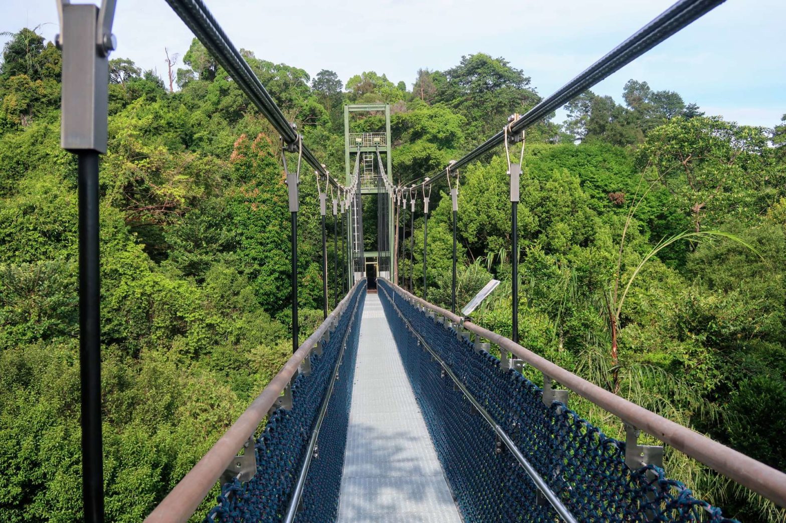
The TreeTop Walk starts with a few stairs downhill before you pass through a little wooden cabin and onto the high suspension bridge. The bridge is very high above the jungle floor and spans a deep valley. You are above most of the trees so there are great views across to a reservoir and over the treetops.
We saw a monitor lizard casually resting at the top of a dead tree trunk roughly 10 metres high. I’m not sure how he got here or if he was perhaps stuck. The tree trunk looked very smooth and I could only imagine he would just slide all the way down and crash into the ground at the bottom if he tried to crawl down.
We also saw a monkey walking along the bridge railings. He then sat very neatly and somehow balanced there without falling, even though the bridge wobbles quite a bit when people walk along. I think it’s perhaps the best treetop walk in Singapore since it gives a fantastic view over MacRitchie area and gets you right up close to the trees.
On the other side some stairs led quite a way upwards before heading the long way back down to the end of the one-way route. At the bottom, you meet a large junction with a very straight and slightly muddy track. This is the Rifle Range Link and we took this right, towards Bukit Timah.
Alternative Route Back
If you want to end back at Windsor Nature Park where you started, you can turn left here instead of right to Bukit Timah. This point is about 4 km in, and it’s about 2.5-3 km back to Windsor Nature Park from here.
Rifle Range Link & Road
This track heads straight through the jungle and can be muddy, slippery and sticky after rain. There’s an exciting water crossing 400 metres along this track, but directly after heavy rains, the bridge can be underwater. If so, retrace your steps and head right, right and right again to reach the other side of the stream after a slight detour.
After just over 1.2 km walking along the Rifle Range Link Track, you’ll reach Rifle Range Road. This road is not very busy and in general has more monkeys than cars on it. This road crosses a big highway on a bridge and 300 metres after that, there’s a path off to the right and onto the Pipe Track.
Hiking Shoes for Dirt Paths
Airy, low hiking shoes with good damping but with no waterproofing are ideal for Singapore’s gravel and dirt paths. We really like the fit and feel of Salomon shoes. The grip, comfort and breathability of the Salomon non Gore-Tex X Ultra series (so without GTX label) is great for this hike:
Salomon Men‘s X Ultra 3 Hiking Shoes on Amazon*.
Salomon Women‘s X Ultra 3 Hiking Shoes on Amazon*.
Check out the complete list of hiking gear needed for Singapore:
Pipe Track & Bukit Timah
Once you reach the Pipe Track, head right. You’ll see many pipes and signs about water, from where the track gets its name. It’s quite a unique trail since a rather wide section of jungle has been cleared so the views are more open. There are also quite a few ups and downs on this trail.
At the highest point, there’s a view over the surrounding jungle and distant flats. After admiring the view and having a rest, take the little trail that heads off left towards Bukit Timah. It’s down some steps and then upwards again on dirt paths.
Find more Fun Outdoor Activities in Singapore!
- Visit the Domes* at Gardens by the Bay
- See the animals at Singapore Zoo*
- Explore historic Singapore by Bike*
- Cycle around Pulau Ubin*
We turned left on the Cave Path to head down towards the Bukit Timah entrance area. If you want to extend this hike, you could instead continue onwards and up to Bukit Timah summit. The Cave Path contours along through the jungle, past some caves, before heading more steeply down. It joins the main track just before the visitor centre and Bukit Timah car park where there are restrooms and a water fountain.
Continue out of the park along the road. Just before the road passes through a small tunnel, take the slightly obscure steps up to the Rail Corridor. Head left for 300 metres before taking the pedestrian bridge over the highway and into Beauty World Mall. There are plenty of restaurants and bakeries here to fuel up after your hike, and the MRT station is just on the other side of the mall.
Want to walk through more nearby jungle? Check out our hiking trails around MacRitchie Reservoir or up Bukit Timah. Alternatively, to explore the culture of Singapore, check out the Little India Walking Trail, Kampong Glam, or Joo Chiat Walk. For other hiking ideas check out our Singapore Hiking page.
FAQs for Windsor Nature Park & MacRitchie TreeTop Walk
Windsor Nature Park is open daily from 7 am to 7 pm.
The elevated section of the TreeTop Walk is roughly 200 metres long across a high suspension bridge. The entire TreeTop Walk, which is one-way, is roughly 1 km. However, it starts in the middle of the jungle and the nearest trailhead is 2.5 km away, so in total to do the TreeTop Walk it is at least 6.5 km.
The closest trailhead to MacRitchie TreeTop Trail is in Windsor Nature Park which has a car park or is close to a bus stop. It’s roughly a 6.5 km out-and-back hike from Windsor Park to the TreeTop Walk. Or, try our exciting one-way from that continues from the TreeTop Walk through Bukit Timah.
There’s a bus stop very close to the entrance to Windsor Nature Park which is the most convenient way to reach the park.
Bukit Timah Nature Reserve is open daily from 7am to 7pm.
MacRitchie TreeTop Walk is open 8:30-5 pm on weekends and 9 am-5 pm Tue-Fri. It is closed on Mondays.
Drongo Trail is a 500-metre-long raised walkway through the middle of Windsor Nature Park. A roundtrip from Windsor Nature Park entrance would be roughly 2.5 km and would include some other trails.
Venus Loop is a 1.7 km long walk through Windsor Nature Park along adventurous dirt trails through the jungle.


The treetop bridge is closed on Monday
Thanks for letting us know!
Why the Tree Top Walk’s opening hours is 9am-5pm from Tuesdays to Fridays and closed on Mondays when there are so many visitors wanting to trail the park? Can’t be open from 8am-5 pm on weekdays ?
Hi that’s a great suggestion! You should suggest it to NParks by filling in one of their feedback forms: https://www.nparks.gov.sg/contact-us.