By Vicky · Published Feb. 19th, 2023 · Updated Sep. 21st, 2023
When you buy through links highlighted with an asterisk (*) on this site, we may earn a small affiliate commission at no cost to you.
The hike up Pic Saint-Loup is a fantastic half-day walk with amazing views, a must when in southern France.
Get the route by downloading the .gpx or .kml file below. For navigation with Maps.me on your mobile phone, simply download the .kml file and open to add it to the Maps.me bookmarks.
Location
The Pic Saint-Loup Hike starts from a car park called Parking Montferrand behind the small town of Saint-Mathieu. The last 100 metres of the track to the parking is not paved but gravel. Parking is free but can get busy on weekends in summer, so arrive early.
Tips for Pic Saint-Loup Hike
- Set off early in summer as the car park can get full (especially on weekends) and it can be very warm climbing up the hill.
- Make sure to take a sunhat and plenty of water.
- For another great hike, head to Saint Guilhem le Désert.
- While in the area, hike to the Pont du Gard, or for more hikes, check out our France Hiking Page.
Pic Saint-Loup Hiking Route
From the car park, walk further along the flat dirt track. In about 400 metres, look out for a much smaller path on the left heading through the undergrowth. Follow this path as it first heads uphill gradually, then quickly steepens. The trail is sometimes slightly hard to follow as it heads across rocky open areas, but you’ll be able to see cairns or paint marks every so often to reassure yourself that you’re going the right way.
Château de Montferrand

Keep right at any choice of ways, and soon you’ll have your first view of the ruined castle on top of the hill. This is Château de Montferrand, from the 12th century, and it’s being gradually restored. There are also great views back over the surrounding countryside. The path soon bends right and heads directly towards the castle.
You can’t actually go inside the castle because the building is quite unstable, but it’s worth walking left around the outside to the edge of the ridge. You can see into the castle enclosure, and from the ridge there are views over the valley in front of you.
Return from the ridge and head left on the path which starts through the stones. Continue walking along the path, which leads slightly downwards, before heading right at the junction. The route now roughly contours along the hillside. At the next junction, just over 500 metres, turn right and then soon left. The path is slightly obscure in places, but many people take this trail and you are unlikely to get lost.
At the next junction head downhill to the left and then right along the larger path. In just under 1 km you’ll come to a junction with the out-and-back path heading steeply up to the top of Pic Saint-Loup. Have a break here if needed, then head upward on the path as it zigzags upwards through the trees.
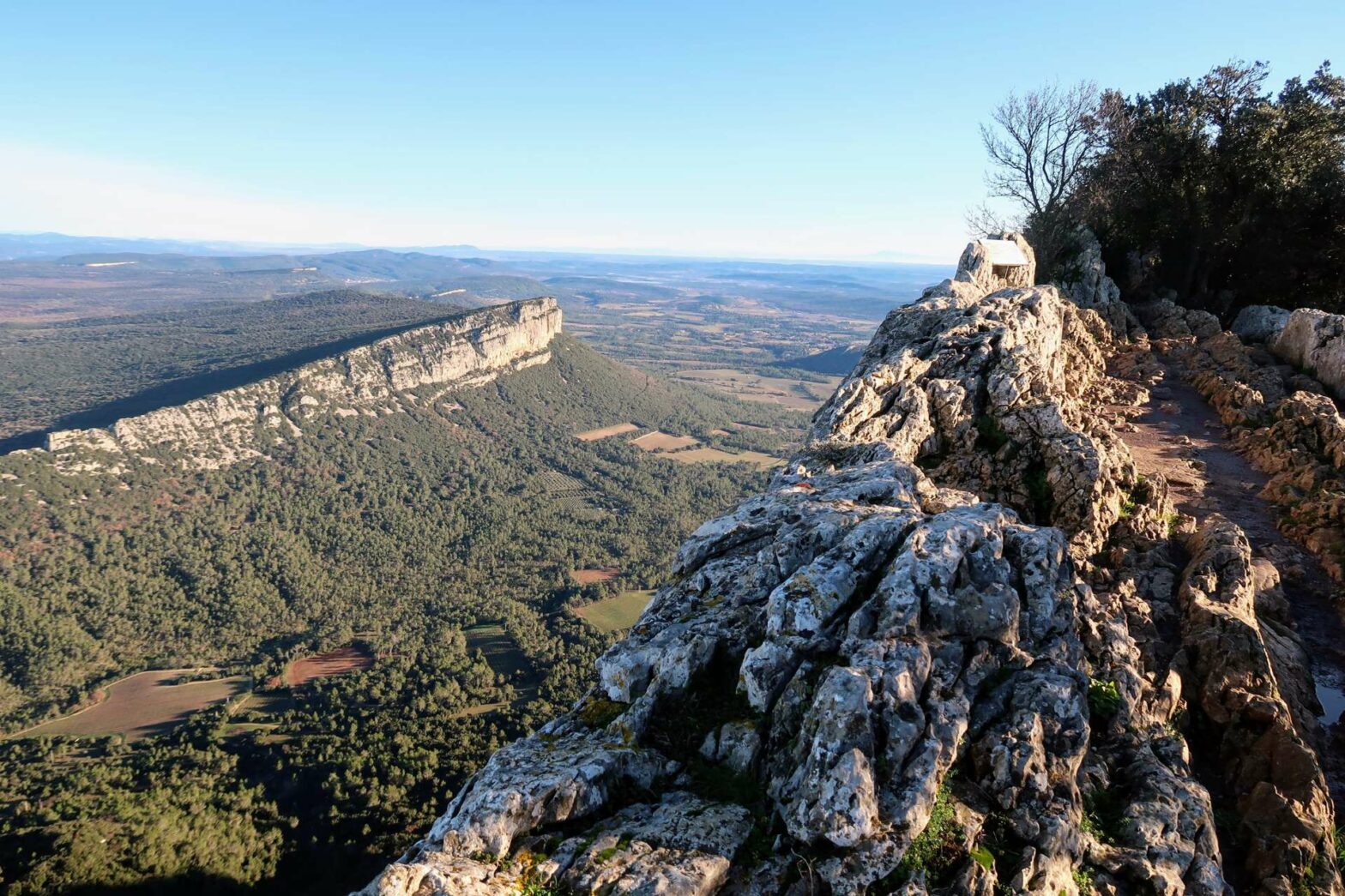
The Top of Pic Saint-Loup
After not too long hiking, you’ll reach the top of Pic Saint-Loup. First you’ll see a chapel, and beyond it a sticking-out layer of rocks. This is a convenient barrier to stand behind while you gaze out at the fabulous view below. You can walk a little to both the right and left, but the hiking becomes a bit precarious if you go too far.
Once you’ve spent long enough admiring the view, head back down the path to the junction. Now, turn right to continue walking around Pic Saint-Loup mountain. This route is easy and very clear and leads all the way down to the outskirts of Cazevieille village.
Walking around the Mountain
When you reach a junction near the bottom, turn right instead of towards the car park. Turn right again when you reach the little lane and continue along the track through the open scrubland, or garrigue. At the next main junction underneath the stone tower, head right and around the ridge into the forest.
Continue walking for about 1 km and you’ll reach a junction. The main path heads left, but a smaller trail leads straight onward. Take the smaller trail through the woodland to avoid extra distance and climb. This path is clear but narrow in places. In about 0.5 km you’ll reach the main track again, and turn right.
The track leads on through a mix of forest and open areas, undulating gently up and down. In about 1.5km at a main junction, head right along the path leading up the hill. This heads to a saddle and a junction you were at previously. This time, turn left along the main track to walk gently down Pic Saint Loup.
Stay on the main, large trail as it zigzags downwards. You’ll soon reach a flat track at the bottom. Turn left and the car park is in a few hundred metres. This is the end of the Pic Saint Loup Hike.
Guidebooks for Exploring & Hiking in Southern France


For other great hikes, head to Saint Guilhem le Désert or walk along Gardon Gorge. Additionally, check out our France Hiking Page.
Related Posts


