By Vicky · Published Jan. 21st, 2023 · Updated Sep. 21st, 2023
When you buy through links highlighted with an asterisk (*) on this site, we may earn a small affiliate commission at no cost to you.
This circular hike from Saint Guilhem le Désert leads you through wild mountains, past dramatic cliffs and great viewpoints before returning to the medieval village.
Get the route by downloading the .gpx or .kml file below. For navigation with Maps.me on your mobile phone, simply download the .kml file and open to add it to the Maps.me bookmarks.
Location
This hike starts from the main square in Saint Guilhem le Désert, next to the old abbey. There’s a large car park nearby, which is €7 for 4 hours or €9 for 18 hours. However, if you stay in the village you’ll receive a free parking pass while you’re there.
Tips for Saint Guilhem le Désert Hike
- If you stay in the village*, you get a free parking permit for the duration of your visit.
- There are cafes/restaurants at the beginning and end of this hike, but bring enough water and food to eat on the walk itself.
- In summer it can be very warm – start early and bring a sunhat, sunscreen and sunglasses.
- This hike includes part of the Cirque de l’Infernet, but is a longer extension which explores more of the park.
- This hike follows the red, white and yellow markers for some of the route, though sometimes it heads through the crosses (denoting the wrong way for those named hiking trails), so don’t get too distracted by these markers.
- For more hikes, check out the walk up Pic Saint-Loup, the Gorges du Gardon Walk, or our France Hiking Page.
Saint Guilhem le Désert Hiking Route

From the square, leave along a small street through an archway, to the left of the Tourism Office. Take the first left along another cute street, and then across at the next junction, heading upwards. This leads you to the edge of Saint-Guilhem-le-Désert village and the hiking trail upwards starts. High above you on the ridge, you’ll see Château du Géant (Castle of the Giant), sitting improbably on a steep rocky outcrop.
The route follows an old, cobbled track that is never too steep. Soon you come to a charming archway in a stone wall, with the hiking trail leading right through it. The track continues to wind up to the ridge, and soon you’ll read the saddle, called Cap de la Crous. To the right is the path along to the Château du Géant, however, this route is forbidden.
Instead of going towards the castle, turn left and after a few metres you’ll come to a viewpoint on the left. From here you can see down to the village and to the impressive rock formations surrounding it.
Hiking into the Wild Mountains
The good trail continues along the ridge and away from the village. After just over 500 metres, at the head of a small valley in a little wood, the path bends around the corner. In a short distance, this hiking route leaves the large marked red, white and yellow route (a GR trail).
At the corner of the zigzag are two obvious red-and-white and yellow crosses. A few meters along the next ‘zag’, a trail marked by a little cairn and two more crosses (the red-and-white cross was quite faded at the time of writing) leaves to the right. Take this path. If you reach the sign about the forest, you’ve gone too far.
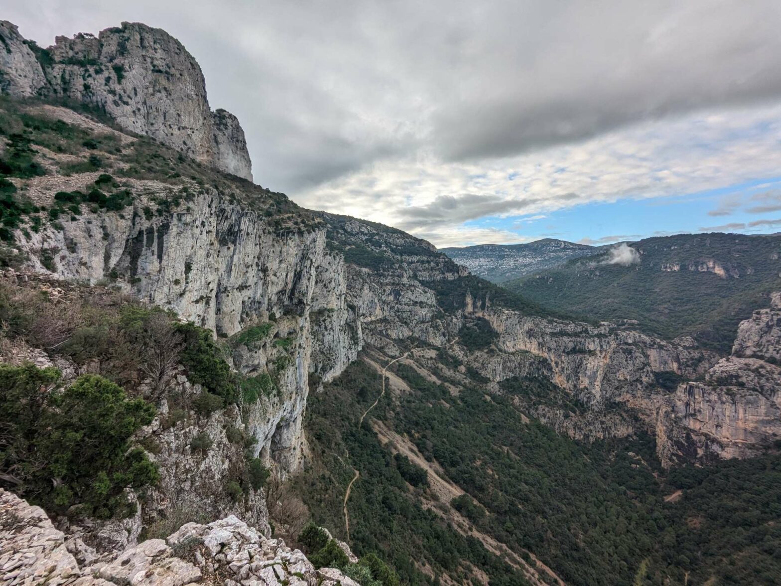
This smaller path leads slightly upwards before heading into some forest and undulating gently through the landscape. In summer, the shade here is a welcome relief. Just over 1 km later, the forest ends and you enter a more open area. Soon afterwards, you’ll reach a great viewpoint at the top of a cliff. On a clear day, you can see the ocean, as well as down to a linear reservoir on the L’Hérault River.
Baume de l’Olivier Cave
The path now continues to the left towards the Baume de l’Olivier (Olive Tree Balm) cave, a rock shelter you can see in the cliffs. The path here is easy but fairly narrow and close to the edge of the cliffs. Make sure to take your time and watch your step.
From the trail, there’s a little path leading up the cave/shelter itself. It’s fairly cosy inside and quite spacious, with a kitchen/dining room space (where people still grill) and a little raised area at the back where you could sleep. A hermit known as Frigoule lived here in winter until a couple of decades ago, spending his life meditating and admiring nature. So spend a while contemplating.
Continue along the path underneath the cave, passing several viewpoints of the countryside on your right. It’s now fairly open and the hiking trail begins to head gradually upwards. You pass through one valley and then around the next corner you can easily see the peak of Roc de la Vigne, high above across one more valley.
Roc de la Vigne Peak
The path heads gently upwards and eventually you reach a path junction in the woods from which there is a short out-and-back to the top of Roc de la Vigne Peak. Take the path to the right, which heads sharply backwards in the direction you came but slightly higher. This route makes a large zigzag before meeting a much larger track by a cairn.
Turn right along the track, then straight onwards along a smaller path again when the track bends the corner. This new path leads up to the slope to the top of Roc de la Vigne Peak. At the top there are some large rocks, and you can climb onto these for a great view over the surroundings.
When you’re ready, walk back down to the first path junction in the woods and now continue to the right. The path contours around the side of a hill and soon you’ll descend to a large track. Turn left here, and the next few kilometres are easy walking along the track.
Walking along an easy Track
You’ll contour around a couple of hills, and then the track ends, becoming a smaller path. From here you’ll see a large valley in front of you, which you have to cross to walk up the other side. It looks like a longer descent and ascent than it really is!
As the path zigzags downwards, you have some great views of large, rocky cliffs surrounding the river to your left. You’ll also pass a few strange rocky columns sticking out of the vegetation. The river, Le Verdus, at the bottom of the valley is often almost entirely dry and you may not notice crossing it.
When the path bends and you start heading slightly upwards again on the other side, walk straight along to the obvious track. Turn right here to follow a well-marked trail leading gradually up the side of the valley.
Max Negre Viewpoint
Once you’ve done most of the climb, you’ll reach a track again near the top. Head left, then left again to reach Max Negre Viewpoint. This is a fantastic spot and the views are great. You can see the dramatic, rocky gorge below, as well as far into the distance and even the Mediterranean Sea.
Head right and there’s another similar viewpoint a few hundred metres along the path. Continue along the path, now following the signs for Saint-Guilhem-le-Désert. You’ll pass a large, bare rocky area to your left, and then the long descent begins.
There’s another great viewpoint on the way down, where you overlook the gorge below. There are many large zigzags, meaning the descent is never very steep, and soon you’ll be at the bottom, on a track next to a football field. Turn right here to walk back into Saint-Guilhem-le-Désert town.
Saint Guilhem le Désert
This is the end of the hike, but if you have the time and the energy, stroll around the rest of Saint-Guilhem-le-Désert. There are many cute streets, and you can enter the old Abbaye de Gellone for free. It’s also a very nice place to stay the night – Les Studios de St Guilhem* is a great place to stay in the centre of town with everything you need if you want to cook for yourself. If you stay in the village, you also get a free car parking permit for the duration of your visit.
Guidebooks for Exploring & Hiking in Southern France


If you’re going to southern France, there are several guidebooks that cover either only Provence & Côte d’Azur (Avignon and east), or Languedoc-Roussillon (Nîmes/Montpellier and west). Because we explored both areas, we opted for Lonely Planet’s France Guide, which apart from including all of France was only slightly more expensive than an individual regional guide.
For more hikes, check out the walk up Pic Saint-Loup, the Gorges du Gardon Walk, or our France Hiking Page.
Related Posts


