By Vicky · Published Jul. 6th, 2022 · Updated Sep. 27th, 2023
When you buy through links highlighted with an asterisk (*) on this site, we may earn a small affiliate commission at no cost to you.
The Albsteig is a 350 km hiking route through the Schwabische Alps. Stage 1 heads from Donauwörth to Harburg, both delightful towns. You can return via a 12-minute train journey.
Page Contents:
Albsteig Stage 1 Map
Get the route by downloading the .gpx or .kml file below. For navigation with Maps.me on your mobile phone, simply download the .kml file and open to add it to the Maps.me bookmarks.
Location
The Albsteig Walk starts at the tourist information in Donauwörth. If you come via train, it’s an additional 900 metres, or 10 minutes walk from the train station to the start of the hike.
Tips for Albsteig Stage 1
- Donauwörth town is worth exploring for an hour or two before you start this walk.
- If you get the train to Donauwörth, it’s an extra 900 m to the start of this hike.
- The route ends at magnificent Harburg Castle, where you can spend 1-2 hours looking around.
- It’s another 1 km from Harburg Castle to Harburg train station, passing through the centre of the old town.
- The train from Harburg to Donauwörth goes roughly every hour, with the journey lasting just over 10 minutes.
- The route is fairly well signed with red triangles on a white background. Sometimes these are quite small and on random lampposts.
- Check out more things to do in Harburg
- Offline maps app Maps.me works well for this hike.
- Check out other great hikes on our Germany Hiking Page.
Donauwörth

To first explore the cute historic town, check out our Donauwörth Walking Tour, which will add up to an additional 5 km to your hike. There are many cafes and restaurants to have a break before you start the first stage of the Albsteig Hike.
When you’re ready to leave, head to the tourist information and you’ll see a signpost with many hiking and biking routes marked. The Albsteig Nordrandweg, HW1, (this hike) is marked with red triangles on a white background. You first walk through a little tunnel before heading left along the town promenade, a park area with remains of the old city walls to your left.
At the far side of the town you’ll walk through a dark old tunnel, originally a railway (from 1849 to 1877) and now only for pedestrians. The first part of this hike follows the old railway line as it contours smoothly alongside the Wörnitz River. There are lovely views over the river and the surrounding countryside.
Roughly 4.5km from the start, you’ll leave the old railway line and head right up a track. You’ll soon come into the town of Wörnitzstein where you head left down towards the Wörnitz River.
Geotop Kalvarienberg Wörnitzstein
Shortly before the river, you’ll see a sign on the right of the road to the Geotop Kalvarienberg Wörnitzstein. Head right up this road and up the steps through the pink archway to reach the small chapel at the top of this small rocky hill. These rocks are ejecta from the formation of a meteorite crater to the north of here, 14.5 million years ago. The rocks were hurled several kilometres through the air due to the powerful impact of the meteor.
You can walk all the way around the chapel where there are several signs (in German) explaining the geology of the rocks. The small chapel is open to have a peak inside, and there are several benches surrounding it that make a great spot for lunch. There are excellent views from here over the river, countryside, and town below. When you’re ready, head back down towards the river.
Cross the river then take the first left and immediate right to walk through the fields. You soon head right again, then left across the railway and right on the other side of the tracks. In a short distance, the path heads left up into the forest.
Bavarian Forest
The next part of the route passes into an undulating forest. There are both pine trees and deciduous trees, with views across grassy areas to the surrounding towns.
You’ll also pass through some lovely wheat fields, and in late spring or summer, many wildflowers are blooming by the edge of the path. At every junction, check for the red triangles on a white background, as the route takes many forks through the forest. Eventually, you’ll leave the forest behind and continue through fields.
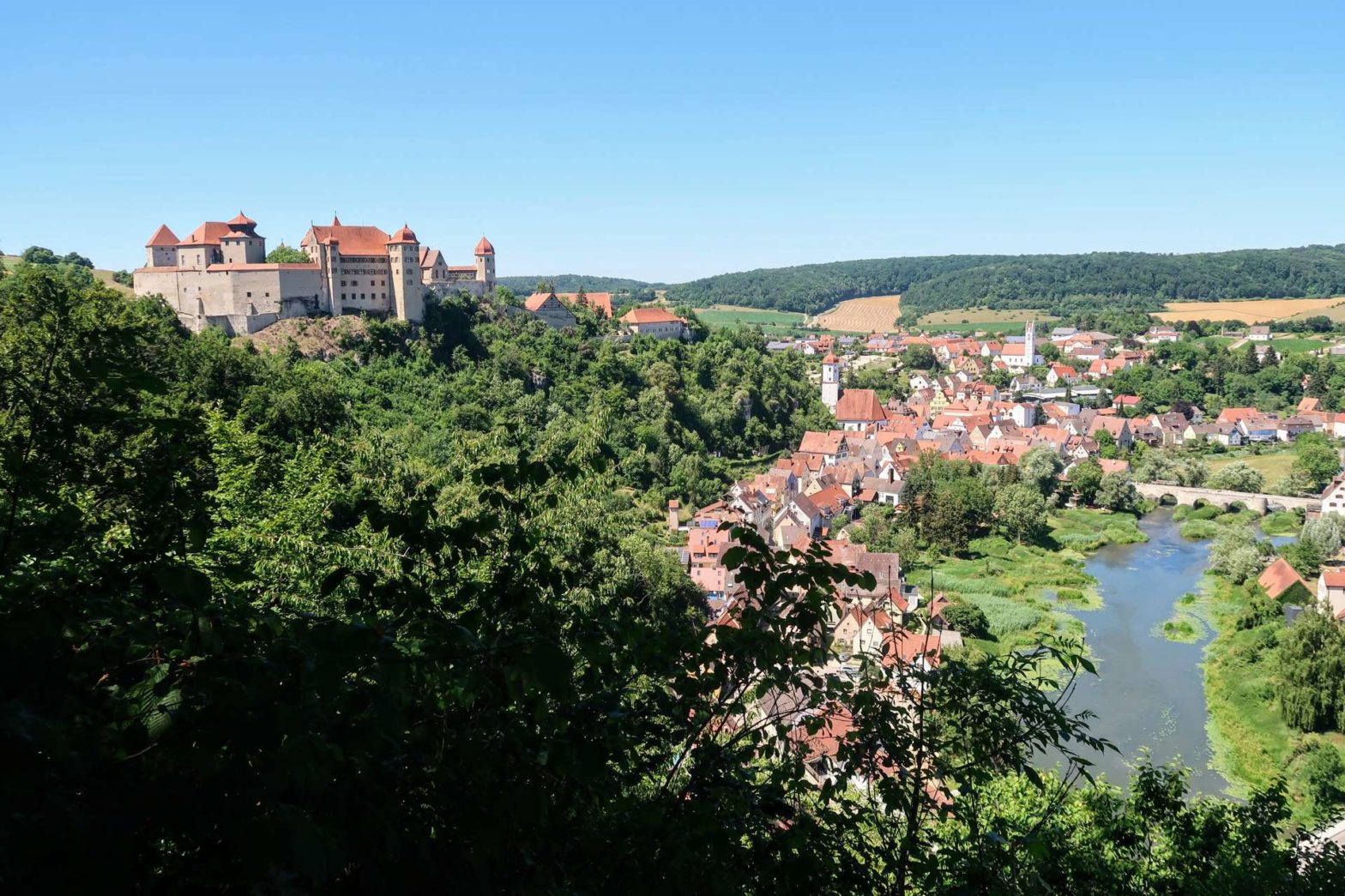
Soon you’ll see the castle of Harburg on the horizon up ahead. Instead of heading straight there, the route winds around a promontory that has great views over Harburg town and the castle itself. Make sure you take the path on the edge of the hill so that you see the views. You’ll find some fairytales in the woods here and signs pointing you towards the castle. The official Albsteig Stage 1 route ends at the castle. The train station is 1 km from the castle, through Harburg Town (see below).
For more information about things to do nearby, see our Harburg Castle, Town and Walks page.
Returning to Donauwörth
The train station is across the Old Stone Bridge and 400 metres further through the town, around a park. Follow Mundlinger Strasse, just to the left on the far side of the bridge. On the other side of the park, turn left to the station.
Trains run only roughly every hour to Donauwörth and the journey only takes about 10 minutes. There’s a ticket machine at the station.
Guidebooks to explore more of Germany


If you enjoyed this walk, check out our other hikes in Germany.
FAQs for Albsteig Stage 1
Albteig Stage 1 is between Donauwörth and Harburg.
The first stage of the Albseig is roughly 18 km. You can walk one way and then take the train back from Harburg to Donauwörth.
Pin it
Related Posts


