By Vicky · Published Sep. 12th, 2022 · Updated Mar. 23rd, 2023
When you buy through links highlighted with an asterisk (*) on this site, we may earn a small affiliate commission at no cost to you.
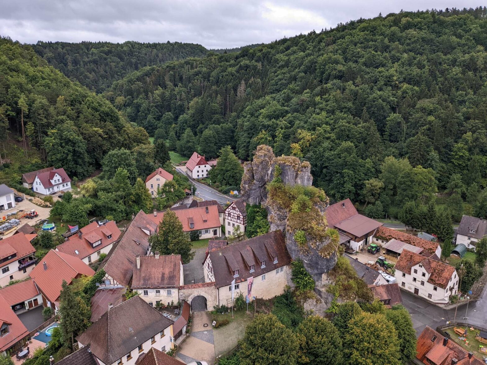
On this circular walk in Fränkische Schweiz see tall cliffs, admire the wonderful rock towers of Tüchersfeld and visit several cool caves.
Get the route by downloading the .gpx or .kml file below. For navigation with Maps.me on your mobile phone, simply download the .kml file and open to add it to the Maps.me bookmarks.
Location
This walk starts from Bärenschlucht Campsite in the middle of Fränkische Schweiz, not far from Pottenstein town. It’s an hour’s drive northwest of Nuremberg. You can also arrive on public transport using a bus from Pegnitz – Bus 389 leaves roughly every hour from Pegnitz train station and stops right outside the campsite and the start of this hike.
Tips for Fränkische Schweiz Walk
- Most of this walk is in woodland, so sheltered from the weather if it’s raining
- Get a hiking map of the area*.
- Wear decent walking/hiking shoes as it’s slippery in places
- While in the area check out the Nuremberg Walking Tour
- Offline maps app Maps.me works well for this Walk.
- Find other great hikes on our Germany Hiking Page.
From the campsite, head out to the road. You’ll see the bus stop here, which goes to Pegnitz, 30 minutes away to the east. On the opposite side of the road, and slightly to your left, you’ll see a path heading upwards into the forest. Take this path and you’ll soon see a large cliff face covered with climbing spikes. There’s also a picnic bench here in case you feel like having a rest before you start the hike.
Bärenschlucht Campsite & Accommodation in Fränkische Schweiz
We stayed at Bärenschlucht Campsite the night before this hike. Campingplatz Fränkische Schweiz is another camping option nearby. If you prefer a hotel or holiday rental, the cute towns of Pottenstein and Tüchersfeld have several options*.
Bärenschlucht Campsite has lots of space for tents or caravans and covers a flat area at the bottom of the narrow valley surrounded by tall rocky cliffs. It’s quite an atmospheric place to stay.
Head right along the small path beneath the cliffs. You’ll contour along near the bottom of the steep valley, with tall rocks up above you to the left. The path winds around the hillside, and on occasion, you walk along by the river at the bottom of the valley.
After about 2 km, you’ll descend to the other campsite in the valley and walk through it. After the outdoor seating area, head left and follow the signposts that point up some steps and back into the wood. In a few hundred metres, go down the steps to your right, following the signs to Tüchersfeld village.
Tüchersfeld
Walk across the main road and into Tüchersfeld. You’ll see a distinctive rocky tower above the town. Wander right and then left up the road towards the back of town. From this street you’ll see signs to the Fränkische Schweiz Museum.
Fränkische Schweiz Museum
The Fränkische Schweiz Museum is located around a historic courtyard just below the rocky tower in the centre of town. It’s open every day from 10:00-17:00 in Apr-Oct, and open Sundays only from 13:30-17:00 in Nov-Mar. Exhibits in the museum include those about the history of the region, covering everything from geology to archaeology to the Middle Ages and handicrafts.
Continue onwards through town along a quiet road with fields to your right and a hill on the left. At the backside of this hill is a car park and the start of the trail to the viewpoint over town, called the Zeckenstein.
Zeckenstein Viewpoint
The small path heads up through the forest along the ridge. After some ascent, you descend back down some steps and around the side of the hill. You’ll then reach some metal ladders that bring you to the top through holes in the rocks and a fun path that twists and turns. There’s a bench at the top and a good viewpoint over the town of Tüchersfeld and the surrounding countryside.
Continuing Onwards
Once you’ve admired the view, return back to the car park. Head along the road and take the first track on your left, by the village sports area. This track follows along a valley and soon into the forest again.
Kühloch Höhle (Cool Cave)
As soon as you enter the forest, you’ll see a sign for Kühloch Höhle. This is a very short out-and-back trail to a cave. The cave is fairly large and you’ll find a bench in one of the openings. You’re not allowed in the cave from the 1st of October until the end of March because of bats roosting inside.
Pferdsloch Höhle (Horse Cave)
After returning to the main hiking trail, a few hundred metres later is another sign pointing to a path up to the left. This trail parallels the main trail and visits Pferdsloch Höhle. This is a fun cave, or rather passageway in the rocks, that you can walk through. Perhaps it gets its name from the fact a horse could also walk through this passageway.
Heading to Rackersberg
The path continues along and rejoins the main track. Take the first on the right, signposted Rackersberg. Take another right and you’ll soon reach the town. On the road through town turn left, and note the many large wooden barns in the village. After 200 metres, take a right at the signpost. You’ll soon be out of town and in the Fränkische Schweiz Countryside, with many fields and views over the surrounding hills.
At the T-junction turn right then quickly left. Follow this path as it leads you back to the paved road. Turn right, and the road heads downwards through the rocks and back to Bärenschlucht Campsite.
This is the end of the walk in Fränkische Schweiz. Check out the Nuremberg Walking Tour, or if you enjoy hiking, check out our other hikes in Germany.


