By Vicky · Published Aug. 29th, 2022 · Updated Dec. 22nd, 2023
When you buy through links highlighted with an asterisk (*) on this site, we may earn a small affiliate commission at no cost to you.
Hike from Neuschwanstein Castle over the mountains to Schloss Linderhof, staying overnight at Kenzenhütte mountain hut.
Get the route by downloading the .gpx or .kml file below. For navigation with Maps.me on your mobile phone, simply download the .kml file and open to add it to the Maps.me bookmarks.
Page Contents:
Location
The hike from Neuschwanstein to Linderhof starts from Hohenschwangau bus stop, just underneath Neuschwanstein Castle. To reach Hohenschwangau you can take Bus Line 78 from Füssen Bahnhof which takes just over 5 minutes. Remember to check for the correct day on the timetable.
This hike ends at Schloss Linderhof. Bus 9622 (timetable) leaves from the bus stop at Schloss Linderhof and goes to Oberammergau train station. From here there are trains to Munich or you can return on public transport to Füssen, though there’s not a direct connection.
Tips for Neuschwanstein to Linderhof Hike
- Hiking poles* are recommended for this hike
- You need a sheet sleeping bag* for the hut
- We use this map* for hiking near Füssen.
- Offline maps app Maps.me also works well for this hike and can be especially useful in poor visibility.
- If the weather is bad and visibility poor, take the bad weather route option.
- The overnight hut, Kenzenhütte, can get fully booked on Saturdays in Summer so book in advance.
- If you are too tired, or the weather is awful, there’s a bus from Kenzenhütte down to Halblech and another bus from there back to Füssen.
- Check out other great hikes on our Germany Hiking Page.
Day 1: 17 km, 1500 m up, 1000 m down

From the centre of Hohenschwangau, head towards the ticket office to the castle. Before you get there, take the signed hiking trail leading uphill to the left. Walk through the wood to a road, and head straight across up a steep path to reach another track. Head left and follow the signs to Marianbrücke.
Tegelberg Cable Car Route
If you want to shorten the first day, you can walk straight from Hohenschwangau to Tegelberg Cable Car Station and get the cable car up to the top of the ridge. The walk along the valley is 2.2 km with 50 metres climb to the cable car. If you take this route, you avoid the long climb up the ridge, which is 5.8 km with 900 metres climb.
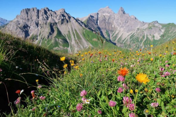
There are great views of Schloss Neuschwanstein from Marianbrücke, and you’ll get more views as you hike up the mountain. After admiring the views, continue across the bridge and follow the path as it zigzags upwards. There are several viewpoints of the castle and you’ll soon be able to see the turquoise Alpsee lake in the background.
Eventually, the zigzags come to an end. On Maps.Me or similar apps you’ll see a path heading right along the ridge, though it isn’t obvious on the ground. Don’t attempt to take this route unless you have climbing experience (it requires Grade II climbing abilities). The main path continues to the left and even heads slightly downwards.
Soon you’ll pass underneath the cable car and meet the main track leading to the top cable car station. There’s a restaurant here and also a terrace just below at the Tegelberghaus where you can buy drinks and food. There’s nowhere else on this hike to get food apart from the end of the day at Kenzenhütte.
From the top of Tegelberg Onwards
From Tegelberghaus head up the track and right towards Ahornspitze. The path roughly follows the contours with nice views of the wild, forested mountains on your right. After almost 2.5 km you’ll reach a sign pointing to the very top of Ahornspitze. The smaller path heads upwards and it takes 10-15 minutes to reach the top. The highest peak is the rocky one on the left. It involves an easy scramble, but to avoid this you can simply walk to the grassy, slightly lower peak to the right.
We ate lunch at the top of Ahornspitze, from where there are great views. The route then returns to the main path and continues a little way downwards to reach Ahornsattel. Take the signed route left here and once around the corner you’ll come to a beautiful grassy Alpine meadow dotted with trees.
How difficult is the Neuschwanstein to Linderhof Hike?
The walking route has no real difficulties, though hiking poles* are recommended for the steep ups and downs. The little scramble to the very top of Ahornspitze is the most difficult bit, but it’s barely even a scramble, mainly just a rocky walk upwards. If you want you can miss out this part.
There’s a steep climb up and over Gabelschrofensattel which could be slippery when wet but there is very little exposure and the track is well-signed. If it’s very bad weather, the lower bad weather route is on easier paths through forests and fields. Make sure you have a physical map*, compass*, and an online mapping app on your phone such as Maps.Me.
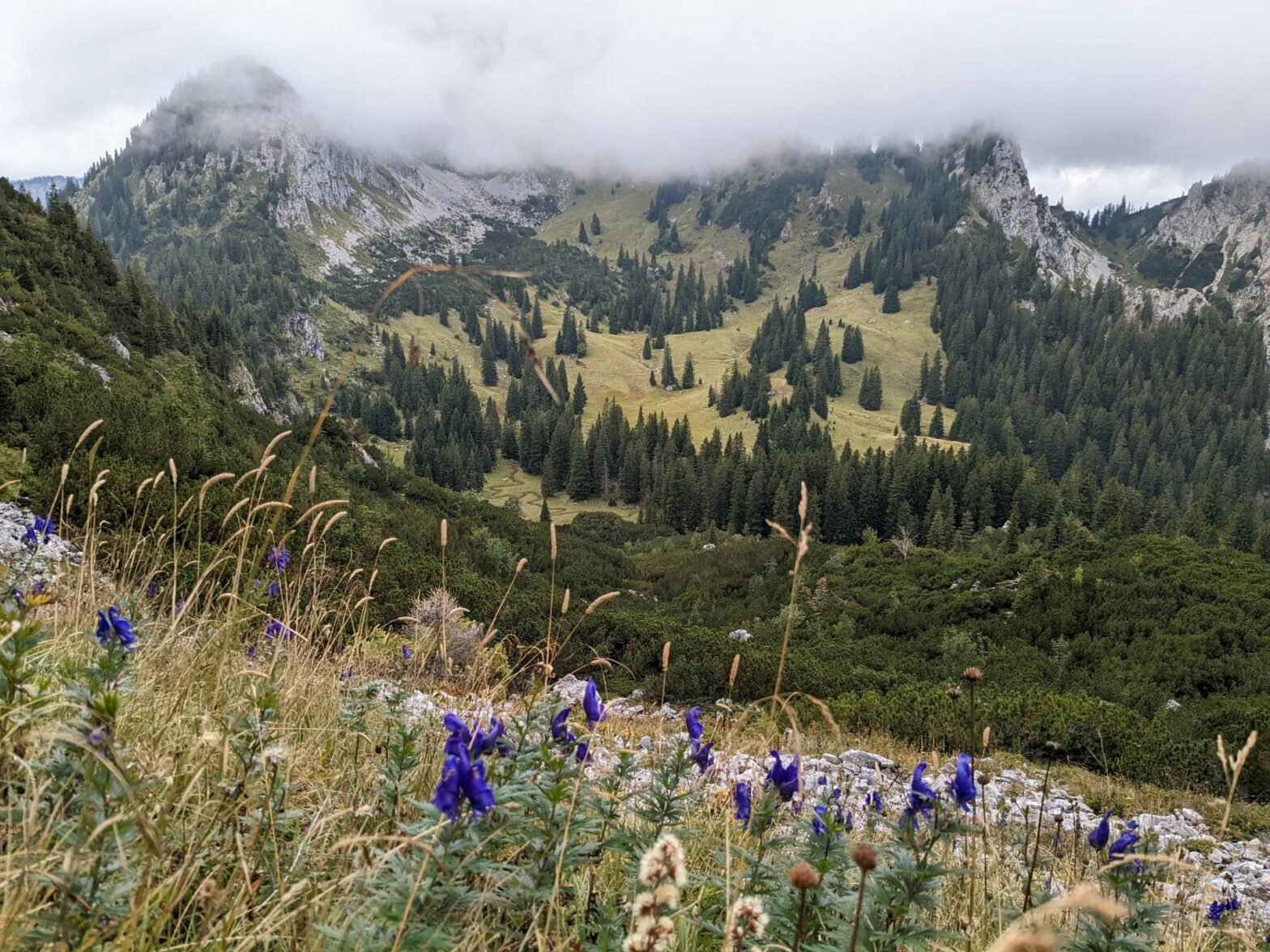
On the other side of the meadow, follow the sign again left, towards Kenzenhütte. After a beautiful straight track almost perfectly flat, you’ll reach a very impressive rock wall and the route now zigzags upwards. At the top is Gabelschrofensattel. After a break here, continue onwards to zigzag back down the other side. Keep your eyes peeled for chamois (goat-antelopes, or Gämse in German), we saw a lot in this valley.
Once you reach the valley floor the path heads through a rocky, bush-covered area, a very wild area. The route then continues to head upwards for a final, gentle climb to another saddle. It’s not far to the overnight hut now, and the path descends downwards and enters some pine forest. You’ll see a waterfall below (you can see it much better from below, a short walk from the hut) and the path joins a main track. In a few hundred metres you’ll see Kenzenhütte and can reward yourself with a nice drink.
Staying Overnight in Kenzenhütte
Kenzenhütte is a small mountain hut roughly 1300 high in the Algauer Laps. There are proper beds in rooms or lagers, which in this hut are quite luxurious and you get your own double bed (in a bunk bed). Pillows and rugs are provided, but you must bring a sheet sleeping bag*. It’s also a good idea to bring a headtorch* so you can find your way about when it’s dark. Book far in advance for Saturdays in mid-summer as Kenzenhütte can get full.
The hut is not part of the DAV (German Alpine Club) but works in a similar way. You can book for bed and breakfast, or book halbpension (half-pension) which includes a three-course set dinner. This starts promptly at 6 pm so try not to be late. A road leads to the hut (private cars not allowed) and there’s a bus stop by the hut so if it’s awful weather you can take the bus the next day down to Kenzenparkplatz in Halblech and another bus from there back to Füssen.
Our experience at Kenzenhütte
We stayed at Kenzenhütte on a Saturday in late August and the hut was almost completely full. Shortly after arriving, before we got too cosy, we walked 5 minutes to the nearby waterfall, which was surprisingly impressive. It was rainy so we sat inside, which was very warm because of the log fire. We had the half-pension option, which includes a three-course meal for dinner and a buffet breakfast.
Breakfast, from 7 am to 8:30 am, involved bread with toppings (chocolate spread, jam, cheese, ham) and cereal with yoghurt or milk. Additionally, there were apples and boiled eggs. Breakfast also includes unlimited hot drinks and orange juice. We woke up at 6:45 am and after a hearty breakfast, left around 8 am.
Day 2: 9 km, 275 m up, 625 m down
The second day of the walk from Neuschwanstein to Schloss Linderhof via the mountains is fairly easy and relaxed. From the hut a small, signed path leads through the open woodland towards a saddle. There’s about 250 metres of climb up to the saddle, and that’s almost all of the climb for today. Head straight over the relatively flat saddle and begin the descent towards the valley.
After about 1.5 km of walking downhill on the path, you’ll reach a main track in the forest. The descent continues until you reach the Sägertalbach stream. The track follows the stream gently along the valley floor all the way to the main valley. Follow the signs towards Schloss Linderhof and soon you’ll come out in the large car park, just past a woodchips storage barn.
Turn left and walk through the buildings to reach the ticket office and entrance to the palace grounds.
Schloss Linderhof
Like Neuschwanstein, King Ludwig II the Fairytale King, also built Schloss Linderhof. The grounds are fairly extensive and it’s a beautiful setting in a forested valley between soaring, rocky mountains. The grounds are free to enter but you need a ticket to visit the inside of the Schloss, which you can only visit on a guided tour. On summer weekends there are tours almost continuously, in both English and German. The tours last about 25 minutes and you get to see most of the rooms inside, all heavily gilded in gold.
In the grounds make sure to check out the Maurischer Kiosk (Moorish Pavillion) and the Venus Grotto if it’s open (closed in 2022 for renovation). On both sides of the palace, you can climb up the valley sides a little way for great views down below.
If you’re hungry, there’s a cafe by the ticket office, but nothing to eat on the grounds themselves. There’s also a little kiosk by the bus stop. After exploring the castle, head to the bus stop, just past where all the large coaches are parked. There are buses roughly every hour (but not at 1 pm), check the timetable for details. Buses go to Oberammergau, from where you can get a train back to Munich or elsewhere.
Guidebooks for Hiking in the Alps


If you enjoyed this hike, check out the nearby hike up Säuling Peak or our other hikes in Germany.
FAQS for Neuschwanstein to Linderhof Hike
Yes, you can hike between Schloss Neuschwanstein and Schloss Linderhof through the mountains while staying in a cute mountain hut.
Yes, there is a bus to Schloss Linderhof from Oberammergau, which takes about 30 minutes. It’s Bus Line 9622 and there’s one bus roughly every hour.
Pin it
Related Posts