By Vicky · Published Aug. 1st, 2022 · Updated Dec. 22nd, 2023
When you buy through links highlighted with an asterisk (*) on this site, we may earn a small affiliate commission at no cost to you.
The hike up Säuling Peak is well worth the effort, with fantastic views at the top. This route leads over the peak from Germany to Austria, with a bus back.
Page Contents:
Säuling Peak Hike Route Map
Get the route by downloading the .gpx or .kml file below. For navigation with Maps.me on your mobile phone, simply download the .kml file and open to add it to the Maps.me bookmarks.
Location
The Säuling Peak Hike starts in the centre of Hohenschwangau (location of Neuschwanstein Castle) just outside the Information Point. The walk ends at the town of Reutte in Austria. To reach Hohenschwangau you can take Bus Line 78 from Füssen Bahnhof which takes just over 5 minutes. Remember to check for the correct day on the timetable.
To get back from Reutte, take Post Bus 100 from Reutte Bahnhof to Füssen Bahnhof. The journey lasts about 30 minutes and tickets cost roughly €5 per person (have cash). Buses are not that frequent, only every 2 hours, so plan for this. If you are behind schedule, there are some shortcuts you can take mentioned below.
Tips for Säuling Peak Hike
- Bring swimming stuff if you want to swim in Urisee near Reutte (near the end of the hike in Austria)
- This hike could easily be hiked the other way around if you catch the bus from Füssen to Reutte first thing.
- We used this map* for hiking near Füssen.
- It’s quite steep, so hiking poles* are very useful.
- There are several options for shortening this hike (see box)
- Offline maps app Maps.me works well for this hike.
- Find other great hikes on our Germany Hiking Page.
From Füssen Bahnhof we took Bus 78 at 8:35am to Hohenschwangau, arriving around 8:45am just outside the Information Point (there are pay public toilets here if you need them).

After getting off the bus you’ll immediately see the famous Neuschwanstein Castle. There are several viewpoints of this landmark along the way on the hiking trail up Säuling Peak. For now, walk onwards to the T-junction and turn right. In a short distance you’ll see a hiking signpost on the left of the road. Follow the path the sign indicates, upwards and into the forest.
The path heads upwards and there are quite a few route choices, the exact path you take isn’t important but you need to end up at the bus stop near Marienbrücke, which is a convergence of paths. From this paved area, take the middle path upwards heading steeply up along a rocky track. If you haven’t been yet – head to Marienbrücke for a great view of the castle!
Walking up from Marienbrücke
Around the corner this path steepens before reaching a gentler track where you turn left. The route to Säuling Peak is fairly well signed, and follow the track right at the next signpost. At the corner don’t miss the viewpoint of Neuschwanstein Castle. There’s actually a much wider area of fallen trees slightly further up the path giving similar views of the castle.
Around the next corner you’ll get your first views of the summit far above, with rocky cliffs soaring in the distance above you. Soon you’re back in the forest and then reach a small grassy Alpine meadow. The route heads off right along the signed narrow dirt path. The hike only becomes steeper and rockier from here.
The next junction is at a cute little log cabin, again in a wildflower meadow. Head left and up the slope before contouring along just underneath the cliffs above. Soon you’ll reach the steep path to the summit ridge which heads off to the right.
The Steep Path up to Säuling Peak
A ladder and a metal rope help you up and over the first difficult section. The rest of the way is steep, sometimes with a metal rope to help you up, however the metal rope isn’t always needed because there are many footholds and blocks to walk up. Exposure is always fairly mild and this route is rated T3 on the Swiss Hiking Scale.
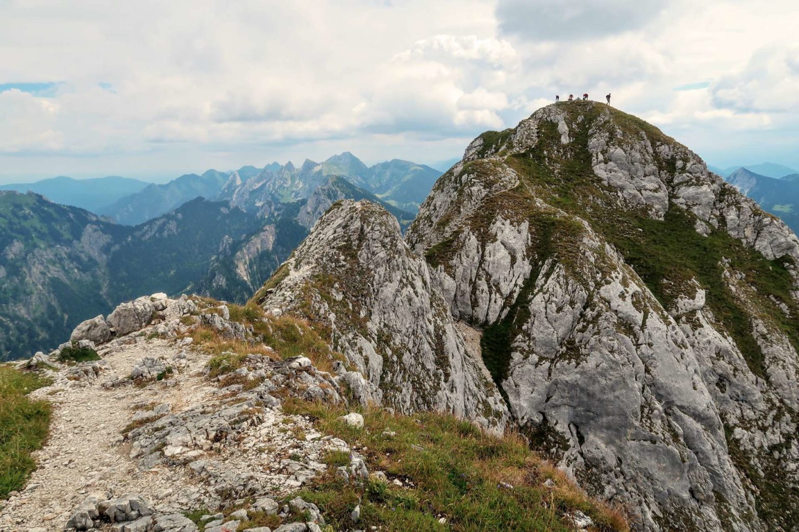
Sometimes there is a minor choice of route, but all the little paths lead the same way – upwards. Before you know it the path flattens out and you can see the plateau of the top ridge. There may well be more people here, those who’ve hiked up from the Austrian side.
To Säuling Peak
Head onwards and up the obvious trail to the summit of Säuling Peak. There are a few slightly tricky sections and the path isn’t always clear, but there are no real difficulties, and quite a few families with children were hiking up. Säuling Peak has a double summit – the large cross is on the slightly lower peak, while the peak on the left is slightly higher but has no markings. From both peaks there are excellent, panoramic views of the surrounding mountains and valleys. It can be slightly crowded on sunny summer days.
We first went to the peak with the cross, then headed over to the higher peak. The route here has perhaps the greatest exposure of the hike, and it isn’t necessary if you don’t want to visit the second peak. After a break at the top, we headed downwards and along the little path opposite in the grass. This led to a bench with great views down into the lakes between Füssen and Hohenschwangau.
Descending into Austria
We ate lunch on this bench before descending into Austria. The trail down was even steeper than the way up. Most of it was secured with metal ropes and the exposure was again fairly mild, with the metal ropes not needed in all places because it was fine just to walk down.
At the bottom of this steep section is Säulinghaus, an Alpine hut that provides refreshments and accommodation. We had a quick drink stop here before continuing on the track towards Pflach and Reutte.
Shortening the Säuling Peak Hike
If you want to return to Füssen from Säulinghaus, take the track that contours around the top ridge of Säuling Peak and back to the cute log cabin where you headed left earlier. This route is 13.5 km with 1200 m of climb, so is 5 km shorter than the main route suggested here.
If you fear you might miss the bus, take the straight, shortest route down from Säulinghaus to Pflach. It’s signed most of the way and it’s 5 km down from the hut to Pflach Kulturhaus bus stop. The same bus Line 100 from Reutte stops at this bus stop a few minutes later. This route takes about 2 hours.
Head down along the track. There are some smaller cut-throughs on a little path which you can take to avoid some of the bends. About 1 km from the hut, a track leads left at a signpost. Take this track, which initially contours around the steeper slopes above.
Towards Dürrenburg Alm Restaurant
When you see a couple of little huts on your right, head downwards and follow the little path signposted Dürrenburg Alm. This path is quite small, but clear and very peaceful with lovely views over the valley to the right.
After 3 km, having contoured around a few little stream valleys, you’ll reach a junction. Turn left and up the track towards Durrenburg Alm. You’ll soon see the restaurant, which is popular with hikers and cyclists. From here a track leads down to Reutte, while a smaller hiking path heads more directly downwards, cutting off the corners of the track.
Beautiful Urisee Lake
Eventually you’ll see Urisee, a beautiful turquoise Alpine lake, peaking between the trees. Head left the other side of the small car park at the bottom to head towards the lake itself. You can walk around the little lake (1.5 km) or take the plunge and refresh yourself in the lovely water. It was surprisingly warm when we were there (late July) and rather idyllic. The only negatives were the sounds of the highway nearby and the large electricity cables strung over the lake.
From the lake, cross under the highway by some steps slightly hidden in the car park opposite. The underpass leads to the other side, and you can continue down a path towards the town. At a green, take the path right on the other side and then left opposite the pizzeria.
Walking into Reutte
This path heads through a little village before reaching a large area of meadows. From here there are great views back up to Säuling Peak and of the other mountains surrounding the valley. Turn left in the middle of the green area to reach a main road (heading straight onwards would lead you to a confusing industrial estate). At the main road turn right, across the railway tracks again, and the bus stop is just on your right. This is the end of the Säuling Peak Hike.
We arrived at the bus stop at 15:45, to catch the bus back to Füssen at 16:05. Since we set off from Hohenschwangau at 08:45, we spent 7 hours walking. We walked quite quickly – there’s another bus at 18:05 (though check the timetable) if you want a more relaxed pace.
Guidebooks for Hiking in the Alps


If you enjoyed this hike, why not try an overnight walk from Fussen, a ridge walk, an amazing overnight hike to Kempter Hut and Großer Krotenkopf, or other hikes elsewhere in Germany.
Pin it
Related Posts


