By Vicky · Published Oct. 12th, 2022 · Updated Nov. 22nd, 2022
When you buy through links highlighted with an asterisk (*) on this site, we may earn a small affiliate commission at no cost to you.
This three-day hike in Swiss National Park brings you through amazing scenery, with majestic peaks, beautiful valleys and a variety of wildlife.
Get the route by downloading the .gpx or .kml file below. For navigation with Maps.me on your mobile phone, simply download the .kml file and open to add it to the Maps.me bookmarks.
Page Contents:
Location
This hike is in the Swiss National Park in eastern Switzerland. It starts from Val Mingèr Bus Stop near S-Charl in Swiss National Park. PostBus Line 913 stops here on the way to S-Charl from Scuol-Tarasp Train Station. The journey takes about 30 minutes and the bus leaves roughly every hour.
The hike ends at Zernez Train Station. You can easily take the train from here to Scuol-Tarasp a journey which takes about 30 minutes. Trains leave from Zernez to Scuol roughly every hour. There’s a free car park by Zernez train station where you can leave your car for a couple of nights if needed.
Tips for Swiss National Park Hike
- Hiking poles* are highly recommended for this hike.
- You need a sheet sleeping bag* for the hut.
- We did this hike in September/October and there was already some snow on the high passes.
- This hike was inspired by a hike in the Walking in the Engadine Cicerone Guide*, though this guide is slightly annoying because it doesn’t have any maps of the routes.
- We used this map* for hiking in Swiss National Park.
- Offline maps app Maps.me also works well for this hike and can be especially useful in poor visibility.
- Accommodation can sell out in Summer so you must book in advance.
- Check out other great hikes on our Germany Hiking Page.
Day 1: 14.5 km, 1100 m up, 950 m down
Val Minger Bus Stop to Sur Il Foss Pass

We started from Val Mingèr Bus Stop and walked across the dam over the stream into Swiss National Park. The path starts by heading gently upwards through a beautiful pine forest. We were there in September/October, and we heard the male red deer grunting all around us up the valley.
As we continued upwards, there were great views of the surrounding mountains, covered in a dusting of snow. Near the top we came across a whole group of people with binoculars and extreme cameras looking at a red deer on the other side of the valley.
After passing this group, we didn’t see any other people until near the end of the day. The route continues up and out of the bowl. It became very windy just before the saddle and started gently snowing. The top of this pass, Sur Il Foss Pass, is 2316 metres high. There was a small amount of snow around, and we could see lots on the mountains across the valley but the path was snow free. It felt very wild and quiet wintery when we were there, with a cosy valley down below.
Sur Il Foss Pass to Fuorcla Val Dal Botsch
There’s a signboard at the pass and a surprisingly large path. We turned left along the path to contour around the hill. If the weather is poor, you can take the bad weather route.
Bad-Weather Route: Down the Valley to Ardez
If the weather’s awful at Sur Il For Pass, there is a nice and easy option to return back to the main valley. This avoids going over Fuorcla Val Dal Botsch, which at 2680 metres is the highest point on the entire hike through Swiss National Park. Down the valley, you end up at Ardez train station. If you’re staying in Zernez, the free transport QR code that you get with your accommodation allows you to take the train for free from Ardez back to Zernez.
We continued onwards but planned to head down the valley on another path slightly further along if we couldn’t get over Fuorcla Val Dal Botsch Pass. Fuorcla Val Dal Botsch is 2680 metres high, and the highest point on this hike through Swiss National Park. The path first heads slightly downwards, across a river, then starts the ascent to the Pass.
The mist came in and the path was covered in snow in front of us. We could see the footprints of one person who must have walked this way earlier, or perhaps the day before. Initially, it was easy going along a clear path heading diagonally up the slope. The slope became steeper and the footprints all but disappeared. The snow was occasionally almost knee-high so it was tough going but we could just make out the route of the previous person. If there isn’t snow, this pass would not be difficult.
After much huffing and puffing, sweating away in our down jackets and hats, we finally reached the top of Fuorcla Val Dal Botsch Pass.
Fuorcla Val Dal Botsch to Il Fuorn
At the top of the pass it was windy and the snow was much wetter on this side, but on the ground it was much thinner. We could see that quite a few people had walked up here from the other side, but turned around without descending into the bowl towards Sur Il Foss Pass. After quickly walking downwards for a few minutes, the snow on the ground had all gone and it even stopped snowing so much.
We sat on some boulders for a brief lunch, with scenic views downwards and over to the opposite side of the next valley. We also heard the ghost of a person walking along the path, distinctive human footsteps yet nobody to be seen.
After halting lunch slightly early because of the cold, we continued on the zigzags into the friendly-looking valley. We could now see many people on a lower circular route, like tiny ants in the distance.
We soon joined their trail in a fairly flat river valley. From then it was easy walking gently downhill back through a forest to the road at the bottom. This is the 28 highway, a fairly busy road right through the centre of Swiss National Park linking Zernez to Austria. I personally think they should build a tunnel (but then you wouldn’t be able to use the bus….).
Cross over the road and there is a walking trail on the other side. Turn right and it’s roughly 1 km to Il Fuorn Hotel and the bus stop back to Zernez. We had considered staying in Il Fuorn Hotel, but it was fully booked and also expensive, so we stayed another night at Camping Cul in Zernez. There are also several other accommodation options in Zernez*.
Bus from Il Fuorn to Zernez
The bus from Il Fuorn Hotel car park to Zernez runs roughly every hour and takes about 25 minutes. It’s number 811. You can plan a route on the Swiss Postbus Website. The last bus leaves down to Zernez around 8 pm and the first bus back up to Il Fuorn from Zernez is around 7:15 am. It’s the only bus (bright yellow) that drives along this road, so you shouldn’t have trouble finding it and the bus stations are all signed.
If you are staying locally, your accommodation should provide you with a local transport card that covers this bus. If not, you can pay on the bus.
Staying Overnight at Camping Cul
Camping Cul is Zernez is a great base for hiking in Swiss National Park, though the valley is high up (almost 1500 metres) so it does get cold at night. With two people, a car and a small tent, it’s roughly €32 per night. Like the hotels in Zernez*, you get a transport QR code that allows you to ride on local public transport.
The campsite is popular with caravans which stay for long periods. There are numbered spots with electricity, or if you don’t need this there’s a grassy meadow where you can pitch your tent anywhere. Near the entrance of the campsite, there’s a little inside kitchen area with stoves and sinks, next to a ‘library’, or sitting room where it’s nice to shelter from the rain.
Free Local Transport QR Code
If you stay in Zernez, the free transport includes the bus up the valley through Swiss National Park until the Süsom Givè (Passo) stop. It also includes the railway between S-Chanf (south of Zernez) and Ardez (north of Zernez). To get to the start of the hike, from Zernez you only need to pay for the section between Ardez and Val Mingèr Bus Stop. This short section is CHF21 per person, so it’s definitely good that some of it is free.
You can use this website to find out in more detail which public transport you get for free based on where you stay – there’s both a Zernez Guest Card and a Scuol/Valsot Guest Card.
Day 2: 17 km, 1250 m up, 1180 m down
We parked our car in the free car park by the station to leave for one night, and took the bus at 8:15 from Zernez train station up to Il Fuorn where we left off the night before.
Hiking Il Fuorn to Ova Spin Lake
We walked down the road for a few hundred metres and took the hiking trail left, signed by a board and signpost. The path heads gradually upwards through pine forest, with many viewpoints over the surrounding mountains.
We saw an amazing rainbow over the valley, and it was very beautiful with the snow-covered mountains and golden grass. After just over 2 km, we came out in a gorgeous Alpine meadow. There were amazing views, to Lago di Lavigno in Italy and several mountain ranges. At the end of the golden meadow was a cute little well-kept hut (not open). There were a couple of benches outside here and it was a great place to enjoy the view.
The trail makes a sharp bend here and cuts back down the slope below the hut. Soon we were zig-zagging down into forest. Again we heard male red deer grunting around us, though today we didn’t see any. At the first junction we turned left, and at the next took the lower fork to the right leading down to the river.
Climbing up Again
After the bridge, the path starts gently climbing again and then undulating up and down. It’s a mix of forest and open areas with views of the mountains.
In one open section, two huge birds suddenly appeared just above us, fighting with each other. They were bearded vultures (Bartgeier), one of the largest birds in the world. They kept flying about nearby, and at one point I thought they were going to attack us, but they were only interested in each other. After a spectacular acrobatic display, they flew off out of sight.
Further on, after about 10.5 km and 420 metres uphill, we came to a junction not far from Ova Spin Lake with a path that can be used as a shortcut to the hut. This point is just 1 km from car park P3, where the bus also stops. If you’re tired or the weather is bad in the morning, you can start from here for a much shorter route. It does however still cross a high pass at 2550 metres, so if the weather is awful, take the bad weather route to Chamanna Cluozza hut as described below.
Junction near Ova Spin Lake to Chamanna Cluozza
We set off uphill at the junction. The real climb begins here, but once at the top the hike is almost over for the day. Initially through forest, soon the trees diminish in stature and gradually disappear entirely until you’re above the treeline. It’s a very scenic pass and there are many photo opportunities.
At the top of the pass there’s a stone cairn and a signpost. You can also now see the mountains on the other side, and into the deep and fairly narrow valley below. The hut is somewhere down here. It can be quite windy and cold, especially once you stop moving. We were lucky and saw a few chamois here, grazing on the nearby grass.
After resting a while and eating some chocolate, we started on the long descent into the cold valley. The path zigzags downwards across the open grass and then heads into the woodland. There’s one section with a cable where the path is quite narrow, but it doesn’t present any major difficulty. Eventually, we saw the hut between the trees and a minute later we were welcomed with a drink of hot tea.
Bad-Weather Route: Zernez to Chamanna Cluozza
If the weather is really bad, instead of heading over the high pass you can walk directly from Zernez up the valley to Chamma Cluozza Hut. This route is 8.5 km with 350 metres climb.
Staying Overnight in Chamanna Cluozza
Chamanna Cluozza is a lovely mountain hut and the only accommodation option on the second day of the Swiss National Park Hike. You have to book half board, which includes dinner and breakfast. It’s open from mid-June to mid-October and prices start from CHF 72 for adults and CHF 26 for young children. Book in advance, as the hut often fills up in summer and on weekends.
There’s a nice terrace outside with a view over the mountains beyond and a telescope for looking at wildlife. You can order hot drinks, beer, cakes and other snacks at any time. Dinner is a set menu (there’s a vegetarian option) and everyone eats together at the same time. We were served a four-course meal of soup, salad, pasta bolognese and delicious bircher muesli dessert.
You can either stay in a ‘lager’ or in a smaller room. In the lager there are mattresses lined up next to each other on the floor, with quite a lot of people in each room. In the smaller rooms, you sleep on a bunk bed. Either way, you must bring a sheet sleeping bag*.
It’s very useful to have a headlamp* to use in the night when the light is turned off, else it’s hard to find your bed again in the dark. At Chamanna Cluozza the toilets are in a separate building outside, so again a headlamp is very useful if you need to use these in the dark.
Day 3: 12.5 km, 825 m up, 1225 m down
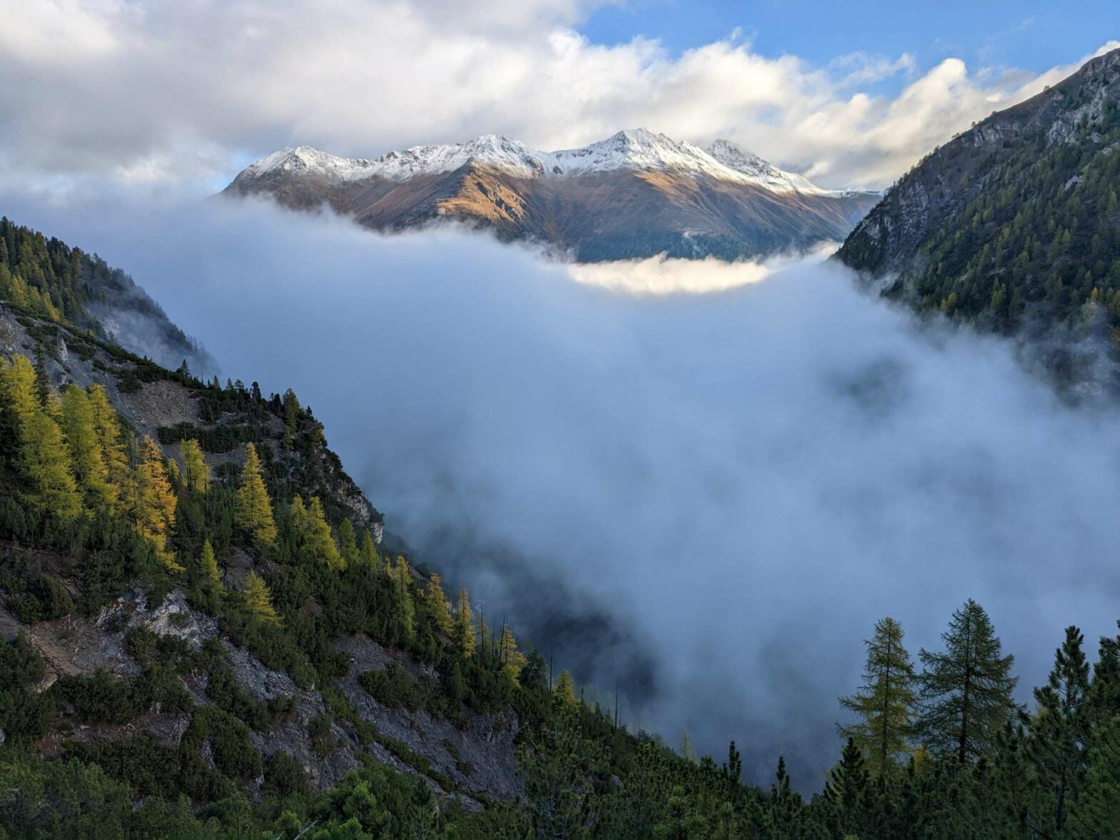
Breakfast started at 7 am and we were almost the first there. There was muesli, bread and many options for jam along with several kinds of cheese. We managed to set off by 7:45 on a beautiful morning, with low-hanging fog in the valley and the bright blue sky above.
Chamanna Cluozza to Murtaröl Peak
From the hut, the path leads downwards through the forest to the stream running along the base of the valley. After the bridge, the path starts to ascend and then contour along the steep hillside through the forest. We had some really amazing views from here, of the fog in the valley and snow-dusted mountains soaring above.
After a while, we reached a junction in the wood. Here you can descend already to Zernez (if it’s bad weather this is the best option), or head upwards to Murtaröl Peak. The bad weather route is 8.2 km with 320 metres uphill and 750 metres of descent. It should take about 1.5-3 hours.
We chose the path up to Murtaröl Peak and began to climb steeply, allowing us to warm up. Soon we came out of the forest and up onto a wide grassy ridge. There were fantastic views and we could hear lots of red deer grunting down below us.
We sat down for a snack and tried to find the deer. Eventually, we spotted them, a few dots walking about far below us. We saw another bearded eagle, though not so close as the previous day. It was really gorgeous, and we continued onwards to the peak.
The peak itself isn’t very impressive. It’s not really a peak but a random point where the path stops with a sign. There’s no path further along the ridge, and you can’t walk off-trail because it’s still within Swiss National Park. The views are great though, and if you look closely you can see the clearing of the hut down in the valley.
Murtaröl Peak to Zernez
From the peak, we returned a short distance the same way before heading left at the signpost to take a different route back down to Zernez. After an initial fairly steep descent, the path bent right and contoured along the hillside. Soon we were back in the woods and descending quickly down the valley.
We went straight over the first two junctions and came out into a field through an archway underneath the railway tracks. After this we soon reached the main road and followed the footpath along it until back in Zernez town. This is the end of the Swiss National Park Hike.
Guidebooks for Hiking in the Alps


If you like overnight hikes in the Alps, check out the Berchtesgaden National Park hike or the hike up Großer Krottenkopf. For more hikes and city walks, see our hiking routes in Germany.
Related Posts


