By Vicky · Published Feb. 27th, 2021 · Updated Nov. 21st, 2022
When you buy through links highlighted with an asterisk (*) on this site, we may earn a small affiliate commission at no cost to you.
Fairfield Horseshoe is a circular walk in the Lake District that’s easy to get to, starting directly from Ambleside. Though long, there are no technical difficulties, and views over Lake Windermere are stunning.

Location
Fairfield Horseshoe circular walk starts directly from Ambleside, in the heart of the Lake District. Paid parking is available at Rydal Road car park, just past the bridge at the northern end of town. We did this hike as a day trip from Ilkley, in Yorkshire, 1 1/2 hours drive away. Coming via public transport, trains arrive into Windemere, a 15-minute bus ride from Ambleside.
Get the route by downloading the .gpx or .kml file below. For navigation with Maps.me on your mobile phone, simply download the .kml file and open to add it to the Maps.me bookmarks.
After paying for a day’s parking, we set off through the streets of town. This first section is one of the easiest places to get lost, as there are many small backstreets, so concentration is needed. You want to end up on Sweden Bridge Lane, which eventually turns into a track. To get here, leave the car park via a wooden pedestrian bridge on the east side, near Mountain Warehouse and the other small shops.
At the main road, turn left, then almost immediately right up narrow Smithy Brow road. After about 100 m, turn left at the triangle junction onto Kirkstone Road. 50 m further, turn left again onto Sweden Bridge Lane, clearly marked by a street sign, and also showing a dead end sign. It’s only a dead end for cars, and soon the road narrows, becoming a track that continues steadily upwards.
Tips
- Take: map, compass, sunhat and sunscreen, waterproof jacket and warm base layers, plenty of water and lunch/snacks, rucksack with a waterproof cover.
- The majority of this hike is on the Ordnance Survey Explorer OL7, Lakes SE* map, except for near the top of Fairfield, which is on Explorer OL5, Lakes NE*.
- This walk is also described in the Walking Guide Cicerone Lake District: High Fell Walks*.
- It’s easy to take the wrong route from the top and end up in the wrong valley. Take a map, compass, phone, if in doubt ask others (the ones who look they like know)
- If walking outside of summer, also bring a woolly hat, and gloves, and be prepared for bad weather.
- Footwear: walking boots, waterproof if you’ve got them.
- Running: Though long with plenty of climb, this circuit would make a pleasant run, as the paths are all fairly runnable, and it’s never too steep.
- There are many variations on this hike, to make it shorter, longer, or one-way over to Patterdale.
- Hike up Walla Crag, or you can find other Lake District ideas in our Lake District Guide, or nearby in the Yorkshire Dales.
If the weather is clear, the most difficult part of the navigation is over. The track continues up a beautiful U-shaped valley, stick on the eastern side of the stream. This valley was planted with lots of young trees in 2019. Reforestation is part of a program to help reduce flood risk downriver, by slowing the water runoff in the upland catchment areas. Although at the moment the plastic tree-protectors look a bit ugly, they’ll disappear soon to be replaced with woodland.
Fairfield Horseshoe Ridgeline
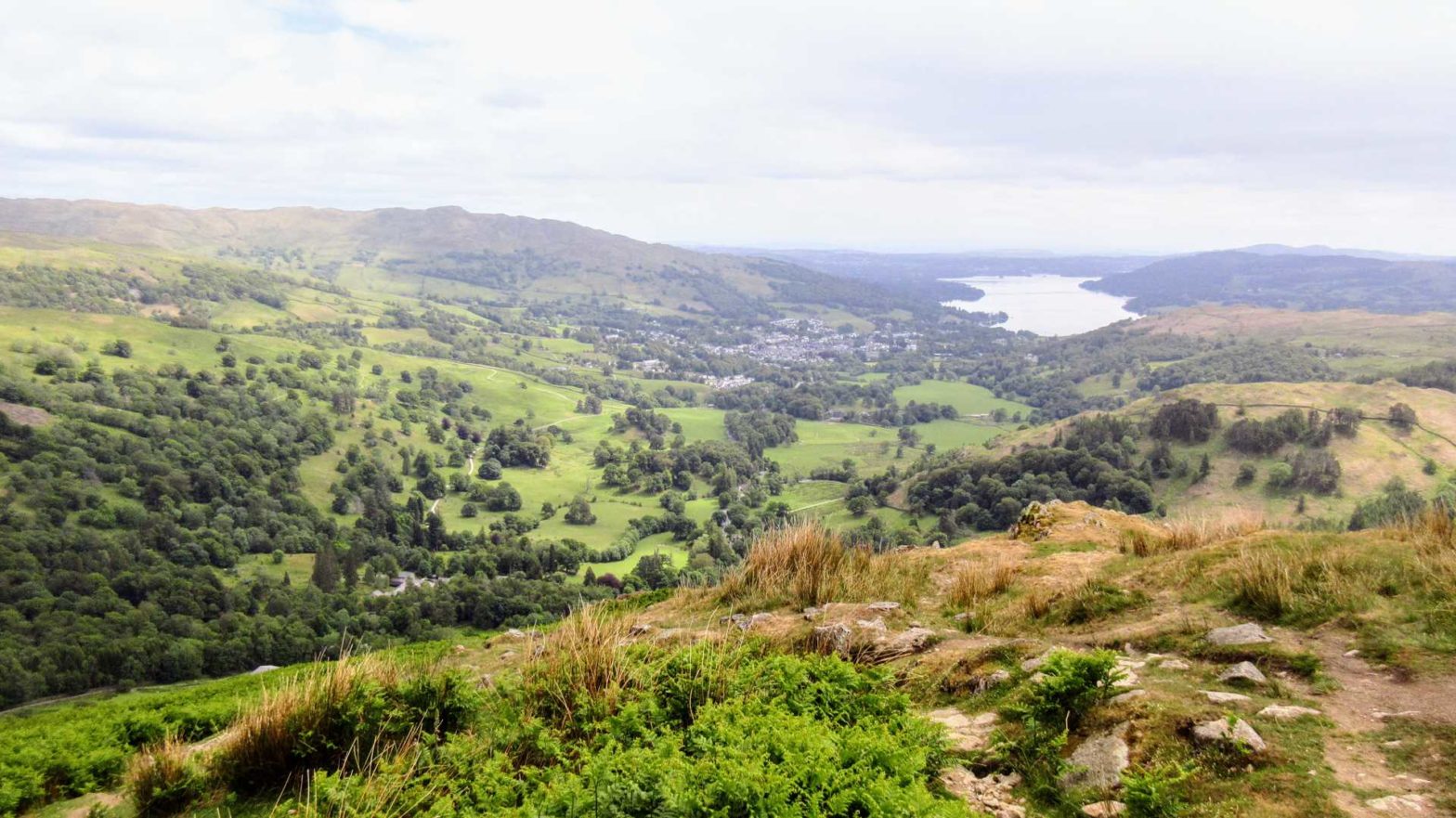
The path steepens at the end of the valley, as you head up to the ridgeline. At a four-way junction at the top, head northwest (left). Follow the top of the ridge about 4 km, until you reach the broad rocky summit of Fairfield Peak. From here you have fine Lake District views. To the north, Helvellyn, and the valley down to Patterdale and Ullswater (an alternative non-circular ending for this hike). Southward, the way down, Ambleside, and two long narrow lakes, Windemere and Coniston water.
To continue the circular walk, you need to now head south. This is a very important junction, and you should check that you take the correct path. It’s easy to become disoriented, as you’re surrounded by lakes and mountains on all sides. Without due care, you could end up heading down the wrong valley without even realizing. If visibility is poor, it’s even more important to check your compass. As a backup, check maps.me (similar to google maps, but with maps and entirely offline) to make sure you’re heading down the path you want to.
Geology of the Horseshow
The mountains in the Lake District used to be higher, but are now continuously eroding. During the last Ice Age, more than 10,000 years ago, huge glaciers carved out U-shaped valleys. This circular walk traverses the ridges around a classic example of a U-shaped valley.
Sandstone and slate are the common rocks on this walk.
As you descend, continue along to the end of the ridge. Rydal Water and Grasmere Lake should come into view in the valley below, with spectacular views all around. These views are what makes it such a great circular walk in the Lake District. The path turns east (left), and descends fairly steeply downwards towards the valley floor.
Sheep in the Lake District
The two breeds of sheep you might encounter on this hike are the local Herdwick sheep and Swaledales from Yorkshire (my favourite type of sheep). These are both very hardy sheep, capable of surviving for much of the year on the high hills, so favoured in the Lake District.
They’re easily distinguishable as Herdwick (apart from the youngest lambs) have white faces and Swaledale black. Additionally, Swaledale sheep have curly horns, and whiter wool, as oppose to the Herdwick’s grey.
Swaledale lambs are mini-mes of their mothers, while Herdwick lambs are born black. If they’re not eaten and grow up, their wool changes from black, to brown, to the light grey of a mature Herdwick sheep.
The red/blue/orange/purple colours sprayed on the sheep allow farmers to identify who’s whose.
Back in the Valley
You arrive at a road and a collection of stone buildings. Accommodation options are available here, along with a teashop serving delicious goodies. The teashop is associated with Rydal Hall, a grand old house, which now offers accommodation to suit all budgets (in Rydal Hall itself* or in super cosy cabins*). Additionally, the formal gardens are also worth a visit. This could be used as an alternative starting point, with parking £5 per day (includes a £2 discount at the tea shop!).
Your hike’s not over yet however, it’s another 2 km back to Ambleside to complete this circular walk. Head past Rydal Hall and the teashop, turning right after the bridge. After 75 m, turn left at the T-junction, and follow the track along the edge of sheep-filled fields. 1.5 km later, you’ll arrive on the main road (A591) on the edge of town. Turn east (left), and after 500 m, the car park will be on your right. You’ve just completed Fairfield Horseshoe, a great circular walk in the Lake District.
Alternative Routes
An alternative route up, which gets you high quicker, but misses out on the U-shaped valley, starts along Nook Lane (instead of Sweden Bridge Lane) and is the first turning on the left as you walk up Smithy Brow road. This route is also circular and leads you to the ridgeline 1.5 km west of the route described above.
A one-way option would be to continue northeast from the top, and down to Patterdale and Ullswater. However, since there is no direct bus back to Ambleside, (you have to go via Penrith), this is only really feasible if you can arrange with somebody to drive you back, or you carry all your gear and continue onwards from Patterdale.
Walking Guides to the Lake District


The High Fells Walking Guide describes this walk. For another great walk in the Lakes, check out Walla Crag.
Related Posts
