By Vicky · Published May. 19th, 2023 · Updated Jun. 4th, 2023
When you buy through links highlighted with an asterisk (*) on this site, we may earn a small affiliate commission at no cost to you.
This circular walk from Austwick to the Norber Erratics and around Crumockdale is one of the best hikes in the Yorkshire Dales.
Location
This walk to the Norber Erratics and Crumockdale starts from Austwick, a small village in the Yorkshire Dales. Parking can be found on the streets of the village, there is no specific car park. There are also several places to stay nearby*.
Norber Erratics & Crumockdale Walk Map
Get the route by downloading the .gpx or .kml file below. For navigation with Maps.me on your mobile phone, simply download the .kml file and open to add it to the Maps.me bookmarks.
Tips
- Take a map, compass, sunhat, waterproof jacket, plenty of water, lunch, snacks, and a rucksack.
- The map to take for this hike is the Ordnance Survey Explorer 2 Map SW Yorkshire Dales*.
- You can shorten this walk by missing out the wood at the end and walking straight back to Austwick (2km shorter).
- The weather can be very variable. Mist can descend quickly, making navigation a lot more tricky, so bring a compass!
- You can find other Yorkshire ideas in our Yorkshire Guide.
Norber Erratics & Crumockdale Walking Route
From Austwick, head to the eastern end of town and left up Townhead Lane. After about 500 metres, turn left on Thwaite Lane, a gravel track, and then almost immediately right onto a path across the fields.

The route is initially along a track, but the path leads off to the right before the track crosses the wall. The path isn’t very clear but keep to the right of the wall. You’ll eventually come to a stile at the end of the field, onto the rough open land above.
Keep by the wall and when it bends left, head right up the hill to the hiking sign, from where there’s a nice view. Turn left here, heading still upwards, signposted Norber Erratics. You’ll head through a pleasant little gully surrounded by limestone cliffs, and out onto some more open land.
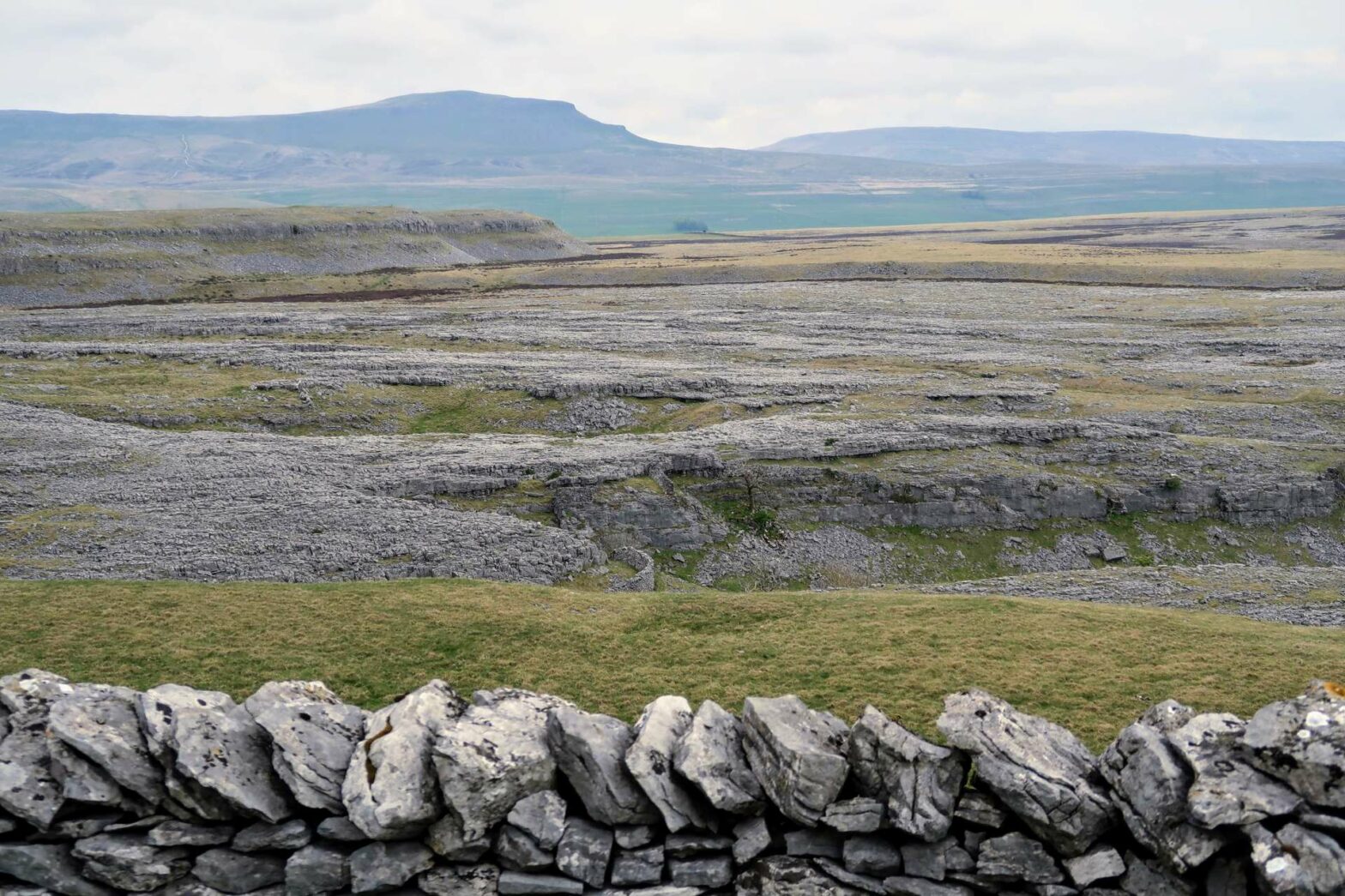
This is where the main section of the Norber Erratics starts. From here you can also see most of Crumockdale, where the walk heads later. You can pick out the erratics by their dark grey colour, and the fact they are perched semi-precariously on top of the rocks below.
The Norber Erratics
The Norber Erratics are the name of the collection of boulders above Austwick in the Yorkshire Dales. They are glacial erratics, meaning they are rocks carried by glaciers for a few kilometres or more, then deposited on top of the local rocks.
In this case, the erratic boulders are made of dark grey sandstone and slate. They lie on top of the paler limestone which covers the entire hillside. Apart from their different colours, the gritsone had bedding, or lines, at an angle to the ground. In contrast, the limestone has bedding roughly parallel to the ground.
The dark sandstone boulders were dropped here when the glacier carrying them melted at the end of the last ice age, roughly 10,000-15,000 years ago. The harder sandstone then protected the underlying limestone from erosion, leaving the boulders perched on pedestals above the surrounding rock layers.
There’s a path across the field, though you can detour from the trail to reach the most dramatic of the erratic boulders. Wherever you wander, aim eventually for the gate near the far top corner of the stone wall.
From here there are a couple of paths you can take (none of these are marked on the Ordnance Survey maps, but they are on Maps.Me and are quite obvious on the ground). Head gradually uphill and then towards the large rock cairn in the distance.
Walking around Crumockdale
Just in front of the large cairn, head right along the footpath and in a few hundred metres you’ll soon join another larger path. Continue along here until you reach Sulber Gate, a gate at a corner of two dry stone walls. Just before the gate on your right is a stile. Climb over here and you’ll be on a grassy plateau with fabulous views of the limestone pavement in Crumockdale below. It’s a top place for lunch!
From this vantage point, pick out the path that leads to the edge of the limestone, as once you descend it can become tricky to find the correct route. As long as you head towards the edge of the plateau and follow the trodden way, you’ll make it through some lovely limestone to a gate. Instead of walking through the gate, turn left to follow the edge of the rocky plateau.
The path here is sometimes unclear, and you do have to do some walking on top of the limestone pavement itself. After a few hundred metres the path becomes clearer again. You’ll reach a side valley, and follow the path as it contours around onto the other side.
Moughton Peak
Along this path, you have the option of detouring to the top of Moughton Peak. It’s definitely worth it as the views from the top are fantastic. There are several small trails leading left, uphill from the path. The clearest one is 850 metres past the path junction at the top of the side valley you just passed. You’ll walk through a small dwarf juniper forest, then slightly down and up again through a grassy dip. The turning to the top of Moughton Peak is less than 100 metres after that, leading about ninety degrees to the left and uphill.
At the top, there’s a trig point and really great views. Most prominent is Pen-y-Ghent to your left, one of the three mountains of the Yorkshire Three Peaks hike. You can also see over Crumockdale and over to the Norber Erratics on the other side.
Once you’ve admired the view, head onwards and downwards to the right to reach the path you left earlier. Again, there’s no one clear trail, but a few small paths that you can choose from. In general, they all lead downwards towards the edge of the cliffs and the top of the dry waterfall.
The main trail crosses the wall just before the dry waterfall and zigzags down a fairly steep slope. Once you cross over the little stream, keep right to head downwards to a larger path. Once here, turn left and keep on gently descending through the field. The path gradually approaches a walled track, with a stile in the wall just past a gate on your right.
Oxenber Wood
Once on the track, continue downwards to the cute village of Wharfe. You have a choice here of heading directly back to the village of Austwick where the hike started (about 1.8 km with very little uphill), or detouring via Oxenber Wood (4 km with about 400 metres climb).
Oxenber Woods are particularly lovely in the springtime when the bluebells and other wildflowers are out (roughly mid-April to May). You may already be able to see the blue-purple colour of the flowers covering the hillside from quite far away, so can tell if the bluebells are out or not.
From Wharfe to Oxenber Woods, walk down the small road leaving Wharfe until you get to the larger road. Cross over, and take the path on the left leading up to the campsite. Follow the hiking signposts past the campsite and left on a path heading diagonally upwards through some fields.
At the top, you’ll reach a track where you turn right. The track becomes a small path and you might already see the spring flowers. After a short distance, you’ll reach an obvious junction with a sign about the plants and flowers of Oxenber Woods. Turn left up the hill here to walk a short loop through the woods (marker on the sign in red).
Keep right and the loop will take you up, over and back down the other side of the woods. Turn right at the larger track to head back to Austwick, and the end of this Norber Erratics and Crumockdale hike.
Guidebooks to explore more of Yorkshire


The Rough Guide to Yorkshire* is a great little guidebook and has a section on Ilkley and things to do nearby. The Yorkshire Dales Pathfinder Guide* has a good collection of short hikes suitable for the entire family and the Guide to North Yorkshire Pub Walks* has some fun walks in the Dales for those who are hungry and thirsty.
For another nearby walk, check out the Ilkley Moor & Burley Moor Hike. Or, for shorter walks, why not walk up Sharp Haw and Flasby Fell, Beamsley Beacon or Embsay Crag.
Related Posts


