By Vicky · Published Feb. 25th, 2021 · Updated Nov. 23rd, 2022
Once in a while, the stars align and snow falls on Matroosberg. This moment coincided with our visit to the mountain and we had a wonderful time in this winter wonderland. A hike from the hot and sunny bottom to the top of Matroosberg in the snow! Of course, you can also hike in Matroosberg when there is no snow.

Page Contents:
Location
Matroosberg is 175 km and 2.5 hours drive from Cape Town. Ceres is the nearest town, 40 km away. It is privately owned (see their website) and there is a 65R fee per person for hiking to the top.
Matroosberg Hiking Map
Get the route by downloading the .gpx or .kml file below. For navigation with Maps.me on your mobile phone, simply download the .kml file and open to add it to the Maps.me bookmarks.
We left our campsite at Matroosberg and drove along the road to the trailhead. They said it was a ‘4×2’ road, but it was quite rough. If you don’t want to drive so far, you can park shortly after you cross the river, just before the tracks split between driving up the hill and driving to the start of this hike. It would add about 1 km each way to your hike along a track.
Tips
- Take a sunhat and sunscreen (sun reflects off snow), and plenty of water.
- Hiking was amazing in the snow, but only happens a few times per year! Set off early before all the snow melts!
- If you haven’t got good tyres, you can park just before the turnoff.
- Hiking poles* are useful in the snow so you don’t fall
- If you are slightly lazy or have young children and have a decent 4×4, you can drive up to near the top.
Very soon after the start of our hike, we saw a crew of dassies hanging out on the rocks. And a couple of other people as well.
Snow and Waterfalls
The waterfalls were all really nice on this trip – especially on the way back, since they were full of snow meltwater, with the snow disappearing before our eyes. Just near the beginning of the hike, there is a great waterfall on the opposite side of the valley.
I thought initially that the hike would be slightly ruined by all the 4x4s driving up, but actually, their track had been designed well, so as to be mainly hidden, and high above on the opposite side of the valley, so we didn’t really notice them at all (until we came across their car park later!).
Geology of Matroosberg
Matroosberg is part of the Hex River Mountains, mainly made of hard sandstone, the same as Table Mountain. There are faults, which pushed up this range, like the other Cape and Fold belts, which were active when Gondwana was forming roughly 250 million years ago.
There was a magnitude 6.3 earthquake in Tulbagh-Ceres in 1969, which caused some damage and loss of life, and you can learn all about it in the Ceres earthquake museum by the Ceres Tourism Office.
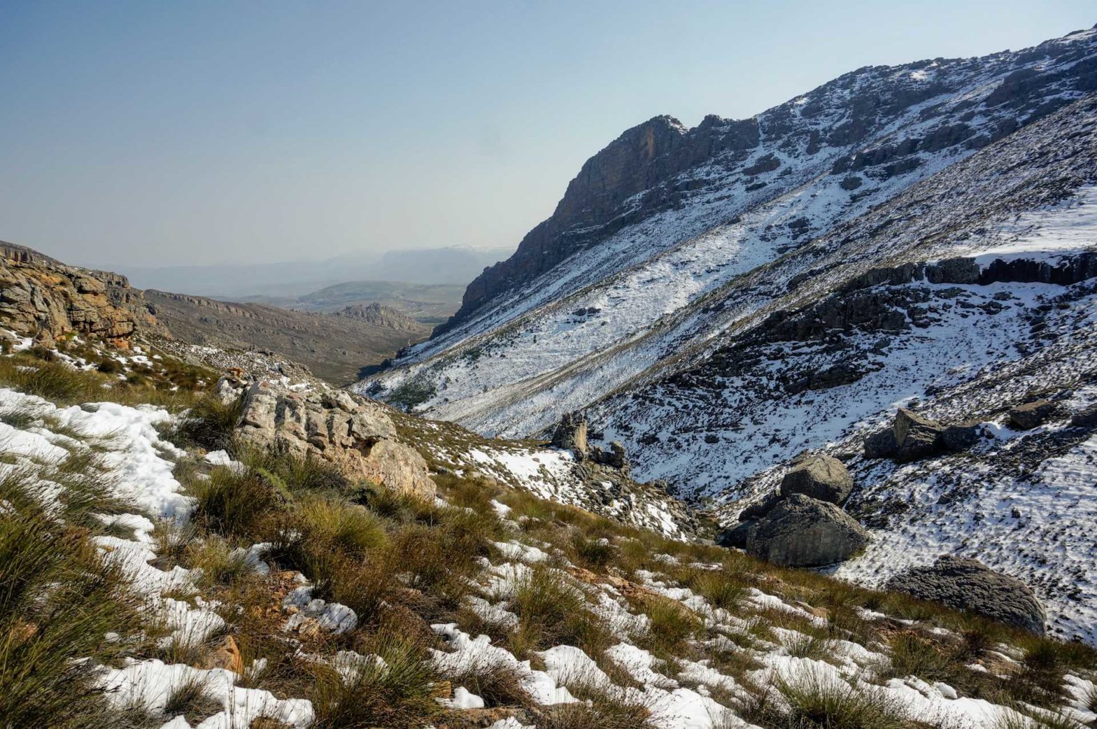
The sun being so strong, there was a significant difference in the amount of snow on different sides of the mountain, with a great contrast between opposite sides of the valleys.
We went slightly wrong on the way up, we continued along the valley too far being distracted by the snow. There were a few other footprints going this way, so you could tell other people had done it too. The real path, which we took on the way down, had left the valley earlier up the rocks and passed by a nice hut in some pine trees. It didn’t really matter that we’d gone the wrong way though, it was a good way up as well.
The path continuing further from this bare rock patch was not very clear. We ended up following a wall that went directly up the mountainside. It was tough work in the deep snow. But with no snow, it would be fine. I think this is the actual path, but too much snow to tell, and I don’t think it is very heavily used.
Matroosberg: Snow and Cars
After following the low wall, we reached a track and followed it to the 4×4 car park… It was very funny to see hundreds of 4x4s up on Matroosberg in the snow. The people who got out of them never moved far from their car. Apart from one group, I think they were on a special guided trip, and had been driven up but were hiking down.
Anyway, we were walking up, just about to reach the car park, and it was uphill and sunny, so we were in shorts and t-shirt. This group coming down was KITTED OUT. Everest-style. They all had on waterproof trousers, multiple tops and thick mountain jackets, hats, hiking poles, serious rucksacks, like for a real mountain expedition. They looked at us funnily, and we in turn looked at them funnily.
Hiking up the track from the mountain car park, there was a guy in a 4×4 who wanted to drive up. But he kept getting stuck in the snow. Then he’d roll back down, open his bonnet and fiddle with the engine for a bit, and try again. Failed again. He did this three times. It was quite amusing – everyone else was watching him too. We felt good just hiking past where he was stuck. One point for hikers, no points for drivers.
We had something nice for lunch, but it just slipped my mind as to exactly what it was. Anyway, we ate it at the top, but huddled in a little stone circle shelter since it was very windy. The views from the top were excellent though.
Origin of the Name
The name Matroosberg means sailor mountain in Afrikaans. Apparently, some rock formation here looks like a sailor(?) or maybe a boat? We didn’t notice it.
Matroosberg is a private ‘nature reserve’ on Erfdeel farm, though it could well be called ‘outdoor adventure reserve’ as for sure it is focused on cool things like 4×4 driving and quad biking, not on nature.
We hiked down the same way (apart from not making the mistake we made on the way up), and it was very quick to get back down. Driving back to the campsite, the tiny trickle we had crossed that morning had swelled to a bit of a river, which our car gallantly forded.
Then we headed back to the campsite for a yummy dinner, and a surprisingly warm night in the cosy forest.
Optional Extensions
Once you get to the top, there are other paths you can hike on, e.g. the quadbike loop, though you have to be careful of quadbikes. It is possible to hike down the opposite side to the Doorns, though for this you would need a car to take you back to the beginning – it’s quite a long drive – and also arrange this with the farmer on the Doorns side.
There are a few shorter walks you do, including one to the Crystal Pools (where you can swim), which we will write about in our future trip report.
Related Posts


