By Vicky · Published Feb. 20th, 2022 · Updated Nov. 29th, 2022
When you buy through links highlighted with an asterisk (*) on this site, we may earn a small affiliate commission at no cost to you.
Visit Marsiling and Admiralty Parks on this varied hike in the north of Singapore, with views over Johor and more.
Marsiling and Admiralty Parks Map
Get the route by downloading the .gpx or .kml file below. For navigation with Maps.me on your mobile phone, simply download the .kml file and open to add it to the Maps.me bookmarks.
Page Contents:
Location
This hike starts from Marsiling MRT station on the red North-South line. Leave the station from Exit D. The hike ends one MRT stop to the east at Woodlands MRT station. As well as being on the red North-South line, Woodlands MRT stop is also on the brown Thomson East Coast Line.
Tips for Marsiling and Admiralty Parks Hike
- Marsiling and Admiralty Parks are open 24/7.
- Take a sun hat, sunscreen and plenty of water along.
- Navigation offline maps app Maps.me works quite well but some of the trails marked are not an option in reality.
- Check out other hikes on our Singapore Hiking Page
From Marisilng MRT Exit D head left around the building by the canal and across the main road to the edge of Marsiling Park.
Marsiling Park

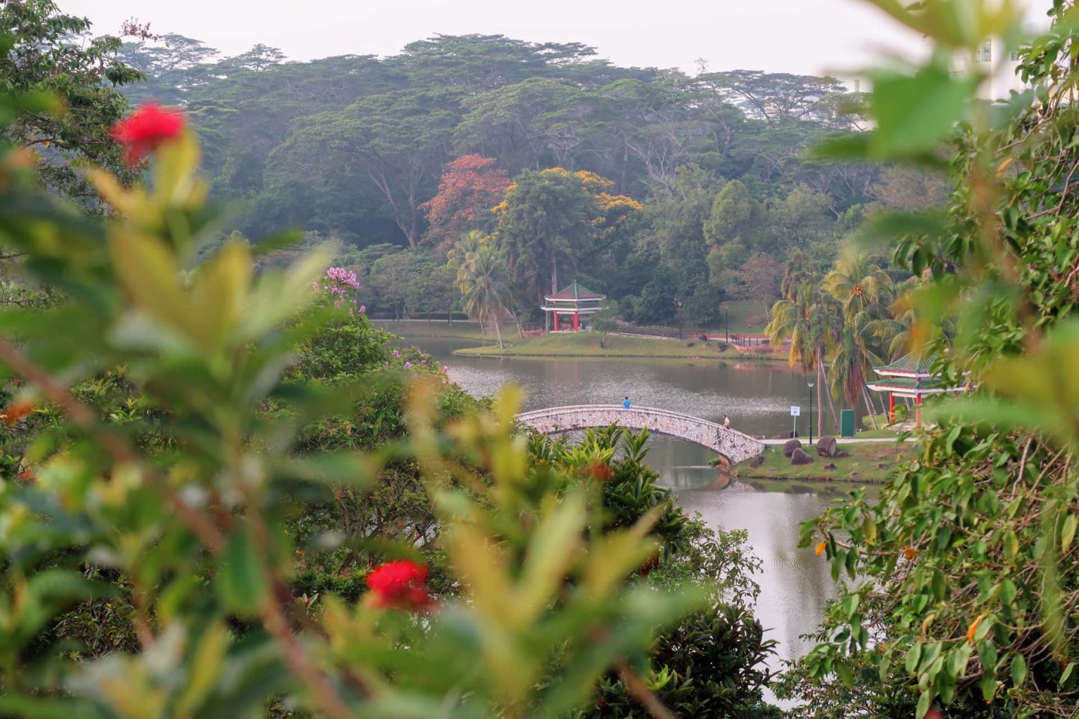
Marsiling Park (previously known as Woodlands Town Garden) is centred on a large lake. There are several nicely painted pagodas dotted within the park and palm trees overlooking the water giving a tropical vibe.
From the edge of the road head up the left side of the canal towards the main section of the park. You’ll soon reach the lake and see the distinctively shaped white bridge in the distance. There are several short sections of boardwalk on the edge of the water with views across the lake.
Continue following the lake until you reach the central bridge. After admiring the view from the bridge, return to the lefthand side of the smaller, circular lake. Walk around the edge and at the far end head towards the white lookout tower just further on from the amphitheatre.
Camera for Beautiful Photos
I’m a big fan of mirrorless cameras with replaceable lenses. I have a Sony NEX 6, which was one of the first mirrorless cameras from Sony back in 2013. Apart from the kit lens that came with the camera and a telezoom lens that I bought for safari, I bought some cheap second hand but high-quality old lenses from the analogue era from brands like Nikon. With an adapter* you can use these on mirrorless cameras, giving you top quality for cheap. My camera is getting old and I will replace it at some point buy a current model from Sony, like the Sony Alpha A6500:
Sony Alpha A6500 Mirrorless Camera on Amazon*.

Of course, cameras with replaceable lenses and advanced features are not for everyone. We have recently been using a Canon PowerShot G7 X Mark II, which still has some good features and excellent low-light performance, but no replaceable lenses:
Canon PowerShot G7 X Mark II on Amazon*.

Check out the complete list of hiking gear needed for Singapore:
Climb up the tower for views back over Marsiling Park, the central white bridge and the colourful pagodas. On descending from the tower, head towards the corner of the park and cross over the road to Marsiling Park Connector.
Marsiling Park Connector
The park connector section of this hike lasts for just over 1 km. First head left after crossing the road and continue across another road until you see a concrete spiral walkway heading upwards. Either take this or the adjacent stairs to continue on Marsiling Park Connector.
At the top, continue left between a grassy open space and HDB tower blocks. At the road head left on the other side, along the park connector following the road as it winds its way down the coast.
The park connector continues as a promenade along the edge of the ocean. There are great views across the straits to Johor Bahru in Malaysia, with a quiet road and jungle on the inland side. After roughly 700 metres of walking along the coast, you’ll reach Woodlands Waterfront Park.
Woodlands Waterfront Park
Once in the park, head left to keep along the edge of the ocean and soon you’ll reach the Woodlands Jetty. There’s no shade on this jetty so it can be quite hot, but the views over the straits are worth it. You’ll also see many people fishing off this pier.
Return from the jetty and keep going left along the path by the trees and water. The park continues for another 500 metres, then you should bend round to the right on a path into the centre of Woodlands Waterfront Park. There are several trails here, we took those that headed uphill for a bit of a view.
Make your way to the main entrance of the park, where there are bathrooms and a water fountain to your right. Head out of the park and up the road. Cross over the main road at the top and into Admiralty Park.
Admiralty Park
Mangrove Forest
Once in the park, head straight across the first path junction to reach the mangroves. This is one of the most interesting sections of Admiralty Park. It looks quite different depending on whether it’s high or low tide. When the tide is high, this area is covered in water, and from the boardwalks, you can see monitor lizards and fish swimming about below. When the tide is out the area becomes a field of mud with small streams coursing through.
Continue along the boardwalk and up the stairs back to the main path. Head left and you’ll soon reach a bridge. This may cross either a body of water or a small stream in some mud depending on the tides. The path continues through some jungle. Head left across the next bridge and be surrounded by thick vegetation alongside the stream.
Turn right on the other side, through more jungle and soon you’ll see some water on your right. If the waterlilies are blooming they bring bright colours above the murky brown water. Slightly further on you’ll see another pond in front of a restaurant, Shiok Garden Hotpot.
Explore more Mangroves in Singapore
- Go Nature Kayaking* through mangrove forests
- See mangroves from a guided boat tour* of Kelong & Pulau Ubin
- Walk through the cool mangroves of Pulau Ubin*
Admiralty Park Playground Area
Walk past the pond and continue through the park. There are two potential routes – a smaller higher path on the left, or the main track in the middle through beautiful rain trees. Either way, you’ll see many playgrounds as you walk along. Some look very exciting and it’s often very busy with families.
Continue through Admiralty Park to the far end and you’ll end up at a road junction. Double-cross the roads to the opposite side and head left along the road on a park connector. In 250 metres you’ll reach a grassy field with a covered walkway heading diagonally across it. Follow this walkway and it will lead you to Woodlands MRT station and the end of this hike.
Want to walk and see more mangroves? Check out our hiking trails in Pasir Ris, or Sungei Buloh Wetlands. For other hiking ideas check out our Singapore Hiking page.
FAQs for Marsiling and Admiralty Parks Hike
The park is open 24/7 and lit from 7pm to 7am.
Marsiling Park is known for its central scenic lake with a pretty bridge across the middle and colourful pagodas.
To get to the park take the red North-South MRT line to Marsiling MRT station. Leave from Exit D, head left around the building by the canal and across the main road to the edge of Marsiling Park.
The park is open 24/7 and lit from 7pm to 7am apart from the forest section which is dark.
Marsiling Park is a medium-sized park of roughly 13 hectares, the same as about 13 sports fields.
To get to the park take the red North-South or Brown Thomson East Coast MRT line to Woodlands MRT station. Leave from Exit 3, walk left at the main road and it’s about 500 metres walk to the edge of Admiralty Park.
Related Posts