By Vicky · Published Jul. 9th, 2023 · Updated Aug. 13th, 2023
When you buy through links highlighted with an asterisk (*) on this site, we may earn a small affiliate commission at no cost to you.
This fairly easy loop hike leads up to Rifugio Fonda Savio, down through a rocky valley, over a saddle, and back via scenic Lago Antorna.
Rifugio Fonda Savio Hiking Map
Get the route by downloading the .gpx or .kml file below. For navigation with Maps.me on your mobile phone, simply download the .kml file and open to add it to the Maps.me bookmarks.
Location
The Rifugio Fonda Savio hike starts from a car park just into the woods off the road between Lake Misurina and the Tre Cime. The car park is free, but it does fill up on sunny days in August, so arrive early. An alternative option is to use the free parking by Lago Antorno, slightly further up the road.
Tips
- This walk is fairly easy, with one slightly more challenging section of steep descent just after the rifugio.
- Rifugio Fonda Savio is open from mid-June to end September.
- For more walks and hikes, check out our Italy Hiking Page.
Rifugio Fonda Savio Hiking Route
Hiking up to Rifugio Fonda Savio
From the car park in the woods, head up the track on the far side leading further into the trees. Keep following the track as it heads gradually upwards and you’ll soon reach Pian dei Spiriti, a flat mountain pasture with another small car park.

From here, take the path to the left, which crosses the meadow and leads up past a huge boulder. The path now becomes steeper as it makes its way up the grassy, tree-covered slopes to reach the edge of a flatter bowl behind the initial steeper cliff.
About halfway up there’s a path junction and you can either choose to head left along the main trail, or straight on which is a small shortcut. They both rejoin each other in a short distance, so it doesn’t matter which one you take.
The path then leaves the forest and heads right. It becomes quite rocky and the path is slightly unclear – there are many little trails all leading to the top of this steep section. Here you also pass underneath the little cable car ferrying goods up to the Rifugio Fonda Savio – the wheels start spinning when it’s in action.
Soon you’ll have completed the first part of the walk up to the rifugio and will now be able to see it in the distance. The second part is slightly more gradually uphill, still on a good trail. The views from the hike are very dramatic, with steep rocky mountains on either side.
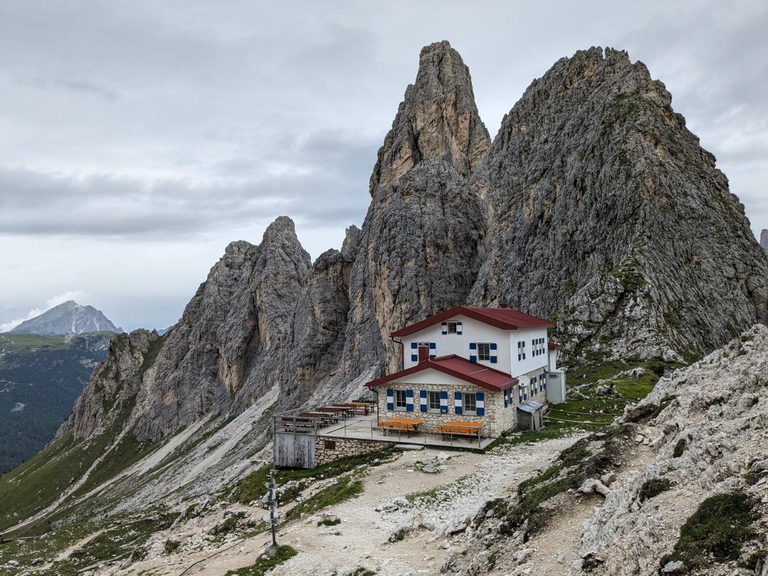
At Rifugio Fonda Savio
Just before you reach Rifugio Fonda Savio itself, there’s a little cliff to walk up. It’s not difficult – there are some wooden steps leading up a gully to the top.
The Rifugio itself has glorious views from the terrace. It’s known in particular for its famous pancakes/donuts/frittatas, which are super delicious. Smoked polenta is another specialty of the hut.
Before you continue with the hike, make sure to walk to the flag on the little hill behind the hut. There are really great views from here into the next valley, and you can see two of the Tre Cime peaks.
Rifugio Fonda Savio to Lago Antorna
The first part of the hike after Rifugio Fonda Savio is the most (and only) difficult part of the hike. There’s a steep downhill on a narrow path that has several cables in place to hold on to. Sometimes you’re just walking down the rock – but there are plenty of good footholds, and it’s possible to manage even without the cable. With the secure cable, it’s not too scary or technical. After this short section the hike is very easy again.
Once you’ve completed the descent, you’ll be in a very rocky valley, which might have a little snow lying at the bottom even into the summer season. This snow is no problem, it’s flat and you can easily walk across following other footprints. The path then continues fairly gently down the valley, all the time surrounded by very impressive mountains.
After rounding the corner, the path contours and heads very slightly upwards to a saddle, Forcella de Rin Bianco. It’s grassy here and flat here, with plenty of places to sit and relax before starting the main descent towards Lago Antorna.
After the break, follow the path downwards. It’s not too steep, and after leading down through the open, heads into a pleasant wood. The trail flattens further and you might see some cows as you wander through the meadows. Soon you’ll reach a main track (heading right on this leads to the Tre Cime).
Turn left on the track, then left again shortly before the road. Cross an open area and near the corner in the road head right into the trees to reach Lago Antorna.
Walking around Lago Antorna
Lago Antorna is a beautiful lake surrounded by trees and flowers. On calm days you can see reflections of the surrounding mountains in the water. We also saw a very friendly duck with ducklings that weren’t scared of us at all – they wanted the crumbs from our hiking bars!
Turn left to walk through the wood around Lake Antorna. Once you reach the open, continue walking up the lake shores a little. This brings you views of the Tre Cime reflected in the water and benches to sit on.
When you’re ready, leave Lago Antorna by walking left along the road a little way. Soon you’ll see a path paralleling the road. Take this, and in a few hundred meters you’ll be back at the car park and the end of the Rifugio Fonda Savio Hike.
Guidebooks for Exploring the Dolomites


For more mountain hikes, check out our Italy Hiking Page.
Related Posts


