By Vicky · Published Jul. 9th, 2023 · Updated Aug. 13th, 2023
When you buy through links highlighted with an asterisk (*) on this site, we may earn a small affiliate commission at no cost to you.
This easy hike from the top of Lagazuoi Cablecar to Lagazuoi Peak then downhill around Col dei Bos loops through a valley with glorious views.
Lagazuoi Peak Hiking Map
Get the route by downloading the .gpx or .kml file below. For navigation with Maps.me on your mobile phone, simply download the .kml file and open to add it to the Maps.me bookmarks.
Location of Lagazuoi Peak Hike
The Lagazuoi Peak and Downhill hike starts from the top station of Lagazuoi Cablecar. To get here, take the cable car up from the base. One-way tickets for the Lagazuoi Cablecar cost €17.50 per adult if bought from the ticket office onsite. Alternatively, tickets are €16 if bought online. You can buy the online tickets at any time and avoid queues at the ticket office – you get a QR code that lets you scan through the gates to the cable car.
There’s a large car park for the Lagazuoi Cablecar at its base with a flat day fee of €5 per car. If you arrive early, there’s a decent-sized free parking on the other side of the road.
Tips
- Lagazuoi Cablecar is open from roughly end-May to end-October. It runs from 9 am and is best to get there in time for the first ascent in order to avoid the crowds.
- You can overnight at Rifugio Lagazuoi, at the top of the cable car, which opens from mid-June to mid-October. If you’re lucky you’ll get fantastic dawn and dusk views.
- This hike to Lagazuoi Peak and back down is very easy, with no technical difficulty and only a small amount of climb.
- For a shorter hike, you can take a shortcut which makes the entire hike down from Lagazuoi 5 km with 80 m of climb and 650 m of descent.
- For more walks and hikes, check out our Italy Hiking Page.
Lagazuoi Peak and Downhill Hiking Route
Hiking from the top cable car station to Lagazuoi Peak

Once you’ve got off the cable car, first admire the amazing views all around. When you’re ready, walk towards Lagazuoi Peak along the large trail that starts towards Lagazuoi Rifugio. This path is also called Sentiero del Fronte, or Front Path, because of the soldiers who used to patrol it during the First World War. On this hike you’ll see many other artefacts from the War such as trenches and bunkers cut into the cliffs.
The trail zigzags around the side of Lagazuoi Rifugio to a splendid lookout. The route to the peak continues to the right, with a choice of paths for those who need a flat route (wheelchairs, prams, elderly) and those who can walk uphill. It doesn’t matter which one you take since they meet a few tens of metres later. You can also walk back on the other path. The flat route is actually slightly scarier since you’re walking on just a metal platform bolted to the cliff.
After a few hundred metres more of easy walking along the broad trail, you’ll wind around to the top of Lagazuoi Peak, at 2835 metres. There’s a summit cross plus many benches scattered around the rocky, flat area. This makes it easy to find somewhere to sit and admire the view.
The Hike down from Lagazuoi Peak
When you’re ready, return back towards the cable car station, perhaps this time via the wooden terrace of Lagazuoi Rifugio. Once you’re back, this time take the obvious trail that zigzags downwards on the rocky slope. As you descend, look out for all the caves, tunnels and shelters from the First World War dug into the cliff on your right.
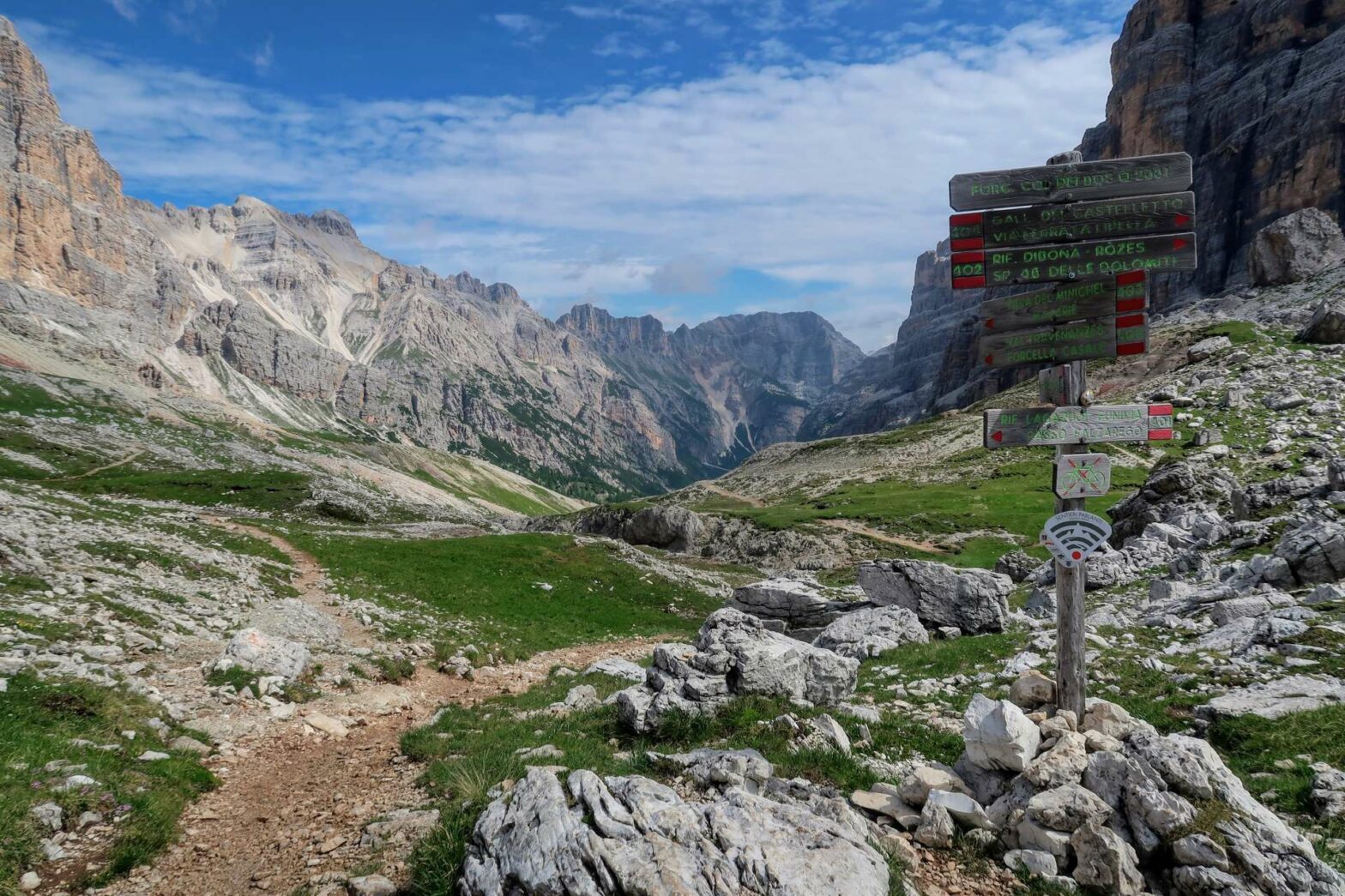
In not too long, the zigzags come to an end and you reach the saddle of Forcella Lagazuoi. From here, take the small path on the right that heads slightly uphill and contours around the hillside. This is a lovely stretch of fairly flat walking with great views, and soon you’ll come to another saddle, Forcella Travenanzes.
If you’re tired or the weather is bad, you can take a shortcut from here that leads quickly and directly back to the car park at the base of the Lagazuoi cable car. To take this shortcut, take the path leading quite steeply down to the right. It’s roughly 2 km back to the car park. This makes the entire hike down from Lagazuoi 5 km with 80 m of climb and 650 m of descent.
To continue with this hike, which loops through a lovely valley around Col dei Bos, head straight on here. The route leads gently downwards through a rocky valley with steep, imposing cliffs on either side. The largest mountain (rock blob) in front of you is Tofana di Rozes, at 3225 metres high. If you look carefully, you may see tiny people on top next to the summit cross.
Hike from Col dei Bos Saddle to Lagazuoi Car Park
Continue walking along the main path until you reach a saddle, Forcella Col dei Bos. Cold dei Bos is actually the name of the mountain you’re walking around. It’s not quite so high as Tofana di Rozes! From here, the route heads between these two peaks and soon you’ll have views down into the main valley.
Keep on heading downwards and you’ll soon meet a large track. You can now choose to walk down the gentle track or take the smaller paths leading more steeply between the zigzags in the track. It doesn’t matter what you choose.
If you take the track, shortly on your left you’ll soon come to a great picnic table with fantastic views. The track then winds its way downwards until eventually you walk through a tunnel cut through the rocks.
After this tunnel, the route continues to head onwards and downwards, with some shade now provided by the surrounding trees. Soon you’ll come to a junction. Take the right-hand track here, which unfortunately starts heading upwards, so be prepared for some climb.
More First World War Buildings
After a few bends and uphill, you’ll come to some more remnants of the First World War. These are a few fairly dilapidated buildings, now undergoing renovation. If it’s a nice summer’s day, you can see people climbing up the Via Ferratas on the cliff faces behind. There are several routes up the rocks here, and the people look very tiny and exposed on the steep rocks!
The path continues onwards, with now only a small amount of climb before the final descent starts towards the Lagazuoi car park. There are some cool boulders and many flowers surrounding this section of the path. You’ll soon reach cars and a track. Head left to return to the base of the Lagazuoi cable car and the end of this hike.
Guidebooks for Exploring the Dolomites


For more mountain hikes, check out our Italy Hiking Page.
Related Posts


