By Vicky · Published Sep. 6th, 2023
When you buy through links highlighted with an asterisk (*) on this site, we may earn a small affiliate commission at no cost to you.
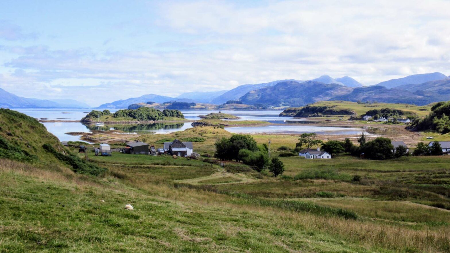
The Lismore Coastline & Castle Walk is a beautiful stroll around a lovely island surrounded by water and mountains.
Location
The Walk around Lismore Island starts at the ferry terminal on Lismore, at the northern end of the island.
Ferry to Lismore Island

The ferry from the mainland to the Isle of Lismore leaves from Port Appin Ferry Terminal. It’s about 50 minutes drive south of Fort William, or 35 minutes from Oban. The Lismore to Port Appin ferry timetable can be found here. The ferry journey takes about 10 minutes, with the first ferry around 7am Mon-Sat and 9am Sun. It’s a pedestrian ferry (no cars) and bikes are carried for free. You can’t book in advance, just turn up at least 15 minutes before the sailing time to buy tickets (£4.60/2.60 per adult/child return).
Lismore Island Walking Trails Map
Get the route by downloading the .gpx or .kml file below. For navigation with Maps.me on your mobile phone, simply download the .kml file and open to add it to the Maps.me bookmarks.
Tips
- Most of this walk is on easy paths and trails, with some walking along minor roads, so plan your footwear accordingly.
- The weather can change very quickly, so make sure to take a waterproof jacket, warm jacket, hat and gloves – even in summer!
- There are refreshments at the lovely Lismore Gaelic Heritage Centre, just over halfway around this walk.
- The map to take for this hike is the Ordnance Survey Explorer Map 376 of Oban and North Lorn*.
- You can go swimming on this walk around Lismore, and it might not be as cold as you expect!
- Why not stay the night in Port Appin*.
- For other walks in the UK, see our UK Hiking Guide.
Lismore Island Walking Route
This walk starts from the ferry terminal at the northern end of Lismore Island. Get here by taking the short ferry ride from Port Appin.
When you arrive on Lisland Island, head through the small car park and turn right. There’s not a super clear path here, just wander across the grass and soon you’ll find hthe proper path.
The Point
The walk around Lismore Coastline starts by heading to The Point. This is the name given to the northernmost point of the island, and it sticks out slightly into Loch Linnhe. Loch Linnhe is the name of the stretch of water between Fort William in the northeast and the Isle of Mull in the southwest. There are already wonderful views across the water from here, similar to from anywhere on the Isle of Lismore! The path continues near the edge of the water, sometimes heading slightly inland, but there isn’t any real route choice.
Port Ramsy & Fennachrochan
Once you’re around The Point, the path heads up and inland to some fields, where you might spot a few sheep. Once you reach the track to the farm, turn right to walk into Port Ramsy. This is a tiny little village with a cute row of white-painted cottages. From here you can see across to some of the smaller islands around the main Isle of Lismore.
At the end of the village, follow the road as it bends left. If you’re already feeling tired, there’s an option to take a shortcut here back to the ferry. To take the shortcut, continue along the road to the next small road, then turn left back to the ferry. If you take this shortcut, the entire walk will be just under 5 km.
To continue on the main walking trail around the coastline of Lismore, take a right on the road just after the bend. Follow this lane as it parallels the coastline and bends the corner into the next tiny village of Fennachrochan.
After passing through most of the village, take a left on the hiking trail heading towards the grassy hills. About 700 metres out of the village, you’ll see a hill on your right. The walking trail is very distinct here, but aim for the top of the hill for some fantastic views. Perhaps have a break at the top while admiring the views, before continuing onwards down the other side.
The path becomes clearer again as you walk along the top of a small cliff, with the ocean not far to your right. Continue on the trail through the fields and you’ll soon get your first glimpse of Castle Coeffin.
Castle Coeffin
After seeing the castle on a promontory to your right, you’ll soon reach a small lane. Head right down the lane to reach the castle. You can walk a short distance around the castle, and also climb up inside. Today Castle Coeffin is a romantic ruin, but it was originally built in the 13th century on the site of a former Viking fortress.
Once you’re done with the castle, there’s a lovely sheltered cove on the east side of the castle where you can swim if you’re brave enough. The water will probably be cold, but compared to elsewhere in Scotland you may find it relatively warm.
After a potential swim, head back up the windy road the way you came. At the top, continue along the road. When you get to the bend, head onwards along the path, which then bends back left towards the road. Turn right at the next junction and you’ll soon reach a crossroads with the main road along the spine of Lismore Island.
Turn right to visit the visitor’s centre. It’s 700 metres along the road, and then back again. If you want to skip the visitor’s centre, turn left instead.
Lismore Gaelic Heritage Centre
The Lismore Gaelic Heritage Centre is a little museum and cafe with a reconstruction of an old cottar’s cottage. The Isle of Lismore Cafe is open from 11am-4pm every day. They serve cakes, soups, sandwiches and bigger meals such as fish and chips. They also sell delicious ice cream and many drinks.
In the little museum you can learn about the history of the island, which has been occupied for thousands of years. Its fertile land and prime fishing grounds have made Lismore Island an attractive target for invaders throughout history. Christianity came here with St Moluag, who founded a monastery nearby in the 6th century AD.
When you’ve finished looking at the museum, cottage, and had some refreshments, it’s time to continue the walk back to Lismore ferry station.
Walking Back along the Spine of Lismore
Return along the road the way you came, and this time head over the crossroads. You’ll soon see St Moulag’s cathedral on your left, actually a rather small church, and you can take a look inside. Continue onwards along the small road and you’ll pass a few more tiny settlements. Keep on following the road and eventually you’ll be back at the ferry and the end of the Lismore Coastline & Castle walk.
Grab a Hiking Guide to Scotland


Scotland’s 100 Best Walks* is a great book to get for hiking inspiration when you’re planning your trip to Scotland. The Cicerone Guide to Ben Nevis and Glen Coe* is the perfect book if you’ve decided to stay in this area, one of the best hiking areas in Scotland. Finally, The Munros* is the definitive guide to the routes up Scotland’s Munros (peaks over 3,000 feet, or 914.4 m).
For other walks in the UK, see our UK Hiking Guide.
FAQS: Lismore Walking Trails
It’s about 40 km to walk around the entire island of Lismore, though there isn’t a path along the coastline all the way so you have to deviate inland and back out again. A better option is just to walk around the northern half of the island in a nice circular loop by the coastline. This shorter route is almost 15 km and takes about 4 hours.
The highest point on the island is the small hill Bàrr Mòr, at 127 metres high. It’s located in the southern half of the island.
The name Lismore comes from lios, meaning garden, and mor, meaning big. So Lismore means ‘Big Garden’.
Related Posts

