By Vicky · Published Aug. 11th, 2023
When you buy through links highlighted with an asterisk (*) on this site, we may earn a small affiliate commission at no cost to you.
The Geology of Ilkley Moor Trail leads you to the highlights of Ilkley Moor, plus helps you understand how this beautiful landscape formed.
Location
The Geology of Ilkley Moor Trail starts from the Cow and Calf car park. This is free, but on sunny summer weekends can fill up early. In this case, parking stretches along the road itself.
Geology of Ilkley Moor Trail Map
Get the route by downloading the .gpx or .kml file below. For navigation with Maps.me on your mobile phone, simply download the .kml file and open to add it to the Maps.me bookmarks.
Tips
- There’s a small cafe at the start/end of this hike called the Cow & Calf Rock Cafe. It’s open 9am-5pm, or until 7pm on weekends.
- You can pick up a leaflet of this trail in the Ilkley Visitor Information Centre next to the library, opposite the train station. It’s open May-Sep, Mon-Sat 9:30-4:30 and Oct-Mar, Mon-Sat 10:00-4:00.
- You can find other Yorkshire ideas in our Yorkshire Guide.
Geology of Ilkley Moor Trail Walking Route
From the car park, walk along the track at the far end and head towards the Cow and Calf quarry. Soon, at a slight bend in the path, you’ll see a fairly large rock on your right with a hole in it. This is Stop 1 on the Geology Trail.
Stop 1, Fossil Pattern

Look at the hole in the rock, and you’ll see a distinctive bark-like pattern in the rock surrounding it. This is the imprint of a fossil club moss tree. The main trunk of the tree itself has been weathered away, leaving only the hole and the fossil pattern.
From here, take the first path on the right towards the Calf Rock – a large boulder on its own.
Stop 2, the Calf Boulder

This large boulder, weighing about 1000 tons, dislodged from the cliff above, called the ‘Cow’, during the last Ice Age. Geologists studied the lines in the rock, called cross-bedding, and determined that the Calf is actually the opposite way up to when the rock formed, i.e. it rolled over when it fell.
Cross-Bedding
Cross-bedding is the name given to the distinctive pattern of repeating lines in a rock, which are often cut across by a layer of lines that repeat in a slightly different direction. These lines are evidence that the rock, made of sandstone, was deposited by wind or water and formed dunes.
These may have been similar to the sand dunes you see near the beach today. The lines preserve the slope of the dunes, with the lines changing direction when a new sand dune forms on top of an older one.
From the Calf, head up the paved track to the entrance of the Cow & Calf Quarry.
Stop 3, Cow & Calf Quarry
Before you enter the quarry itself, look to the right at the boulders and you’ll see some more cross-bedding. Meanwhile, on the left of the entrance, try and find the rocks on the floor that show a ripple pattern. These ripples, fossilised in the stone, are evidence that the rocks formed in an environment with shallow waves.
Head inside the quarry and pick up some freshly broken rock. Look closely and you’ll see clear quartz grains, along with some creamy-white feldspar grains. Feldspar easily turns to clay when weathered, unlike quartz which is very resistant to weathering. The presence of feldspar tells us that the source of the sandstone rocks wasn’t very far away.
When you’re ready to move on, leave the quarry and turn right, up the paved path to the steeper smaller path and to the top of the slope. Keep heading right and then cut across the grassy to stand on top of the Cow Rock. Keep well back from the edge and supervise children closely.
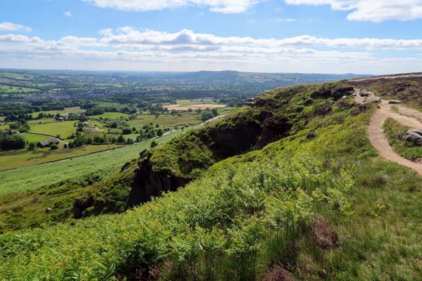
Stop 4, Wharfdale View
From here there’s a lovely view across the valley. Note that the slope on this side is quite steep, while that on the other side is much gentler. The slope of the other side actually follows the natural dip of the rocks, which is about 5 degrees.
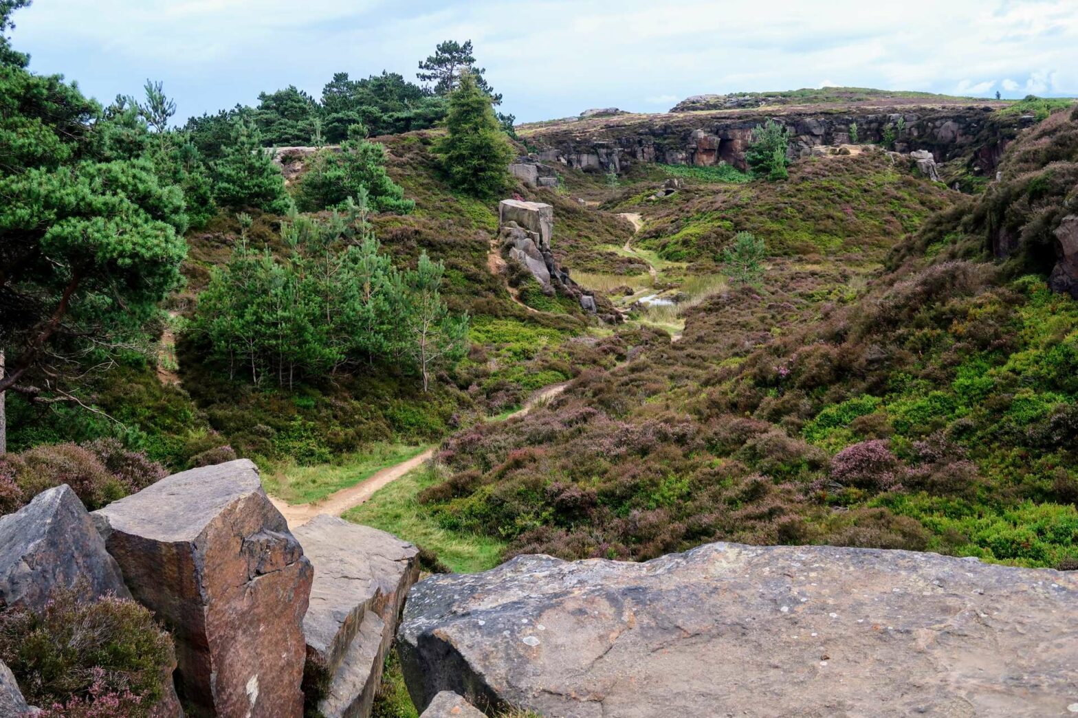
From here, head left and follow the path leading along the right-hand edge of Hangingstones Quarry – the lower area to your left. Continue about halfway along the quarry and you’ll come to a large, flattish rock.
Stop 5, Hangingstones Rock
The top of this rock is very smooth – sandpapered down by a glacier from the last ice age. This made it a popular place for Bronze Age people to carve intricate shapes in the rock. You can see at least two different Bronze Age carvings, plus one much more recent attempt.
Walk down into the quarry itself and continue to the right. Walk up at the far end and again look for the flat-topped rocks.
Stop 6, Glacial Striations
There are two large flat rocks here, both of which have evidence for the movements of glaciers during the last Ice Age. You can see lines and groves on their surface, all in the same direction. These were formed when rocks and debris at the base of the glacier were dragged along the top of the rocks as the ice flowed down the valley. We call these groves glacial striations.
Continue walking onwards to the end of the flat, grassy area. You’re now on top of the Crocodile Rock.
Geology of Ilkley Moor / Gritstone
The main rock type on Ilkley Moor is gritsone. or Millstone Grit. This is a sandstone made of coarse sand grains. It’s fairly acidic and promotes the formation of peat, and the heather which grows on top. In between layers of Millstone Grit you can find shales, which are much darker and finer-grained. The gritstone was deposited in a high-energy environment, such as in a river, while the shales were deposited in calmer water such as lagoons or swamps.
The formation of these rocks occurred about 320 million years ago when the Ilkley area was near the Equator. At the time, a large delta covered most of what is now northern England, surrounded by ferns and mosses, with giant insects flying through the air.
As the Ilkley area moved slowly northward, the climate became cooler and drier, the rocks were uplifted and erosion began. The last, most significant stage of erosion was during the last Ice Age. 20,000 years ago, a huge ice sheet covered Ilkley and carved out the Wharfe Valley, sculpting the landscape you see today.
Stop 7, Crocodile Rock
Below where you’re standing are a couple of rocks that look like the gaping mouth of a crocodile. You’ll see these when you leave this stop. For now, admire the view. To the left you can see Backstone Beck flowing down a small gorge, straight on you can see White Wells, with Addingham Moor behind it. Note the stepped profile of Addingham Moor on the horizon. Harder gritstone forms the steps themselves, while the gentler slopes in between are made of softer, darker shale.
Turn around and head down the small path to your right, then left up the track along the edge of Backstone Beck.
Stop 8, Backstone Beck & Waterfall
This stream flows along a gorge following a minor fault line. The movement on the fault created weaknesses in the rock, which the stream then exploited and eroded downwards. When the rocks on either side of the fault passed each other, the friction created a smooth, orangey-brown surface between them. These are known as slickensides, and you can see them on some of the rocks on the ground along the small path and track. Feel them – they’re very smooth!
The waterfall itself formed where the harder gritstone met the softer shale. The water more easily erodes the shale below, while the gritstone resists erosion, and this creates a cliff and waterfall.
Continue walking up the stream to the junction of several paths. Turn right here to cross the stream, then take the middle trail heading upwards to the ridge above Rocky Valley. At the top, follow the smaller path on the right to keep to the cliff edge for views down below.
Stop 9, Ilkley Crags
The view from here is a lovely panorama up Wharfedale to the Yorkshire Dales and beyond. Just below is Rocky Valley, formed not by a stream but by a large landslip that occurred thousands of years ago. Part of the cliffs you’re standing on now broke off, and slip down the hillside a few hundred metres.
Walk onwards then take the path leading off to the right, before you reach the large cairn. Take the steps downwards, then take the sharp right to walk through Rocky Valley.
Stop 10, Rocky Valley
As you walk through this valley, look out for fossil plant remains on the rocks nearby the path. These are more signs of life from millions of years ago when the rock formed.
Once you reach the end of Rocky Valley, continue down to where you crossed the stream before. Head over, and this time keep walking straight onward and back down to the car park. This is the end of the Geology of Ilkley Moor Trail.
Guidebooks to explore more of Yorkshire


The Rough Guide to Yorkshire* is a great little guidebook and has a section on Ilkley and things to do nearby. The Yorkshire Dales Pathfinder Guide* has a good collection of short hikes suitable for the entire family and the Guide to North Yorkshire Pub Walks* has some fun walks in the Dales for those who are hungry and thirsty.
For another nearby walk, check out the Ilkley Moor & Burley Moor Hike. Or, for shorter walks, why not walk up Sharp Haw and Flasby Fell, Beamsley Beacon or Embsay Crag?
Related Posts