By Vicky · Published Jan. 20th, 2023
This fun walk to and around Pont du Gard leads past several great viewpoints of the bridge and has free parking.
Get the route by downloading the .gpx or .kml file below. For navigation with Maps.me on your mobile phone, simply download the .kml file and open to add it to the Maps.me bookmarks.
Location
This Pont du Gard Walk starts from a free car park in Saint-Bonnet-du-Gard, a small village roughly 20 minutes drive from either Avignon or Nîmes.
Tips for Pont du Gard Hike
- You do not need any ticket or permit for this hike. You only need a ticket if you want to visit the Pont du Gard Museum or go on a guided walk across the top level of the bridge. The museum is very good, so worth visiting.
- Parking right next to the museum is €9, but on this hike the parking is free!
- Set off early in summer – the parking becomes quickly full and the sun can be very strong.
- In summer you can swim in the Gard River which flows underneath the Pont du Gard. Read the signs which specify exactly where you can swim.
- There’s a cafe/restaurant called Les Terrasses near the bridge where you can stop for refreshments. There are toilets here and outside the Pont du Gard Museum.
- If you want to visit the museum, swim, and have a picnic or visit a cafe, you could spend an entire day on this walk.
- For more hikes, check out our France Hiking Page.
Pont du Gard Hiking Route

From the car park, walk along the track heading into the fields and towards the hills. You’ll pass through vineyards with nice views of the rocky hills ahead before the track becomes a smaller path and enters the forest.
The path becomes fairly rocky and leads upwards to a junction with a track on the plateau at the top. You’ll return here later on the way back, but for now head straight onwards along the walking path, following the signs to the Pont du Gard.
The small path leads through the Garrigue (the vegetation type, similar to Chaparral in California or Fynbos in South Africa) and is quite shady. A few kilometres from the parking, you’ll reach the remains of the Pont du Combe. This is part of the aqueduct that took the water across the Pont du Gard and all the way to Nîmes. Unlike the famous bridge, this section is almost fully destroyed.
Head left at the broken bridge, and up to another section of the ruin. Continue onwards and around the corner of the hill. You’ll get your first view of the impressive Pont du Gard from here, sticking out of the green Garigue bushes. You’ll descend slightly to some more ruins of the Nîmes aqueduct. Head onwards and slightly upwards from here, and you’ll soon reach the entrance to a tunnel. Walk through the tunnel and you’ll be at the edge of the top level of the Pont.
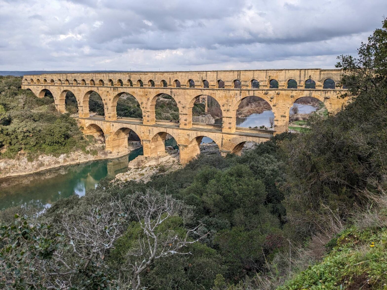
At the Pont du Gard
You can’t walk across the top section of the Pont du Gard except on a guided tour, organised from the museum. For now, head left down the steps leading to the base of the valley. This is the main area where you can see the bridge, and it can be very busy here in summer (so try to arrive early).
There are many little paths and places to go here. We first kept right and passed a prehistoric cave opening, more like an overhang, where now there are sometimes bats. Nearby are some toilets and La Terrasse Cafe. We then walked right and then took the steps down to the river.
One of the best places to view the Pont du Gard is from around here. Head out onto some flat rocks by the water near a little beach. If there water’s warm enough, you can also cool off here. After enjoying the views, walk back up to the paved track and then turn right to cross the bridge itself.
More viewpoints of the Pont du Gard
On the other side head upwards on the steps, which quickly bring you back to the top level of the aqueduct. From here, take the first left along a path leading to several viewpoints of the bridge. Continue onwards, and you can make a short out-and-back to another viewpoint. You can still see the bridge from here, but also have nice views of the river and its surroundings.
Continue winding your way through the Garigue and you’ll soon reach some more remains of the Nîmes aqueduct. Walk along this ruined wall, crossing a road as you do so. Keep along the path as it bends the corner and reaches some more stone ruins. At the end of the ruined wall, turn right and walk along the edge of a field to a main track.
Walking through Traditional Landscape
Turn right and follow this path through woodland and olive trees to a lookout platform. The view from here isn’t amazing, but you can see the bridge in the distance and look out over some of the surrounding towns and valleys. After the viewpoint, you’ll reach the Jardin des Plantes (Garden of Plants). In this garden, they’ve planted specimens native to the area which often have a culinary use.
Head through the garden and right, through some lovely olive orchards. They’ve tried to restore this area to the traditional landscape. Now you can see vines along with olive trees growing in the fields. Head left and then right along a track leading to the Pont du Gard main car park and Museum.
At the Pont du Gard Museum
Turn right at the edge of the car park, and walk between the museum buildings. There are toilets here on the left if you need them, along with a cafe, information and the main museum. Continue onwards and you’ll soon be back at Pont du Gard itself. Cross over again, but this time you want to walk right a little way along the river. To do this you initially have to go left, but then turn left again to head under the end of the aqueduct.
There are more good views from this side of Pond du Gard. Take the first path on the left, which leads upwards out of the valley. There are a couple of minor route choices, but all should lead to the top where there’s another great viewpoint of the bridge.
Walking back through the Garrigue
After the viewpoint, take the first right along a small path through the garrigue. It’s a bit of a secret path, so narrow in places, but always clear. Turn right when you reach the next small path, and a short distance later you’ll reach a main track again.
Turn right to follow the track as it leads gently up a broad ridge. At the top you’ll come to a junction with another track. Turn left here, and note the views across the valley to the right. Soon you’ll be back at the junction with the small path you took near the beginning of this hike. Turn right down the rock path and walk along the track at the bottom to return to the car park. This is the end of the Pont du Gard Walk.
Guidebooks for Exploring & Hiking in Southern France


For other nearby hikes, see our France Hiking Page.
Related Posts

