By Vicky · Published Sep. 26th, 2023
When you buy through links highlighted with an asterisk (*) on this site, we may earn a small affiliate commission at no cost to you.
The Bastei Bridge Hike leads to many viewpoints, across the famous bridge, through Felsenburg Rock Fort, and back up Schwedenlöcher Gorge.
Bastei Bridge Hiking Trail Map
Get the route by downloading the .gpx or .kml file below. For navigation with Maps.me on your mobile phone, simply download the .kml file and open to add it to the Maps.me bookmarks.
Bastei Bridge Location
The Bastei Bridge is in Saxon Switzerland in eastern Germany, close to the Czech border. It’s 45 minutes drive south of Dresden and almost 2 hours north of Prague.
Bastei Bridge Parking
This hike starts from a large car park at Bastei Bridge. It’s €7 per car for up to 4 hours, or €12 for the day. If this car park is full, you have to park at the Park-and-Ride car park 2.5 km up the road. This is €6, and then €1.5 per person for the shuttle bus which runs every few minutes to the bridge.
Don’t try to find cheaper parking in the surrounding villages such as Rathen because they have very strict rules on parking/driving through the town.
Getting to Bastei Bridge on Public Transport
It takes less than an hour to get from Dresden to Bastei Bridge on public transport, with a train to Pirna Station and then a bus right to the car park.
Another option is to take the train from Dresden to Kurort Rathen train station, then a short ferry across the Elbe River. You end up in Rathen, near the far end of this hike, so can start the walk halfway through. Bear in mind that no matter which hiking trail you take, there’s quite a lot of climb uphill to reach the Bastei Bridge from Rathen.
Tips for Bastei Bridge Hike
- Bastei Bridge is open all the time and free to enter.
- Felsenburg Rock Fort, also known as Neurathen Castle, is next to the bridge and costs €2.50/1 per adult/child. It’s open from 9am-6pm all year round. The ticket booth is only manned Apr-Oct, the rest of the year there’s an honesty box.
- Arrive early, for example at 8am, because later the tourist buses arrive and it becomes very busy.
- While in the area, check out the walk up Lilienstein plateau, visit Königstein Fortress, or discover more things to do on our Germany or Czech Hiking Page.
Bastei Bridge Hiking Route

From the car park head along the road towards the bridge. Before you get to the buildings, take the short out-and-back path to Wehlstein Viewpoint. You can’t see the bridge from here but can admire the tall rock columns looming out of the forest.
Continue walking along the road, through the middle of the buildings. At the end, before going to the bridge, head right to another viewpoint. This is the Basteiaussicht (Bastei Viewpoint) and from here there are great views over the Elbe River far below and the surrounding scenery of Saxon Switzerland.
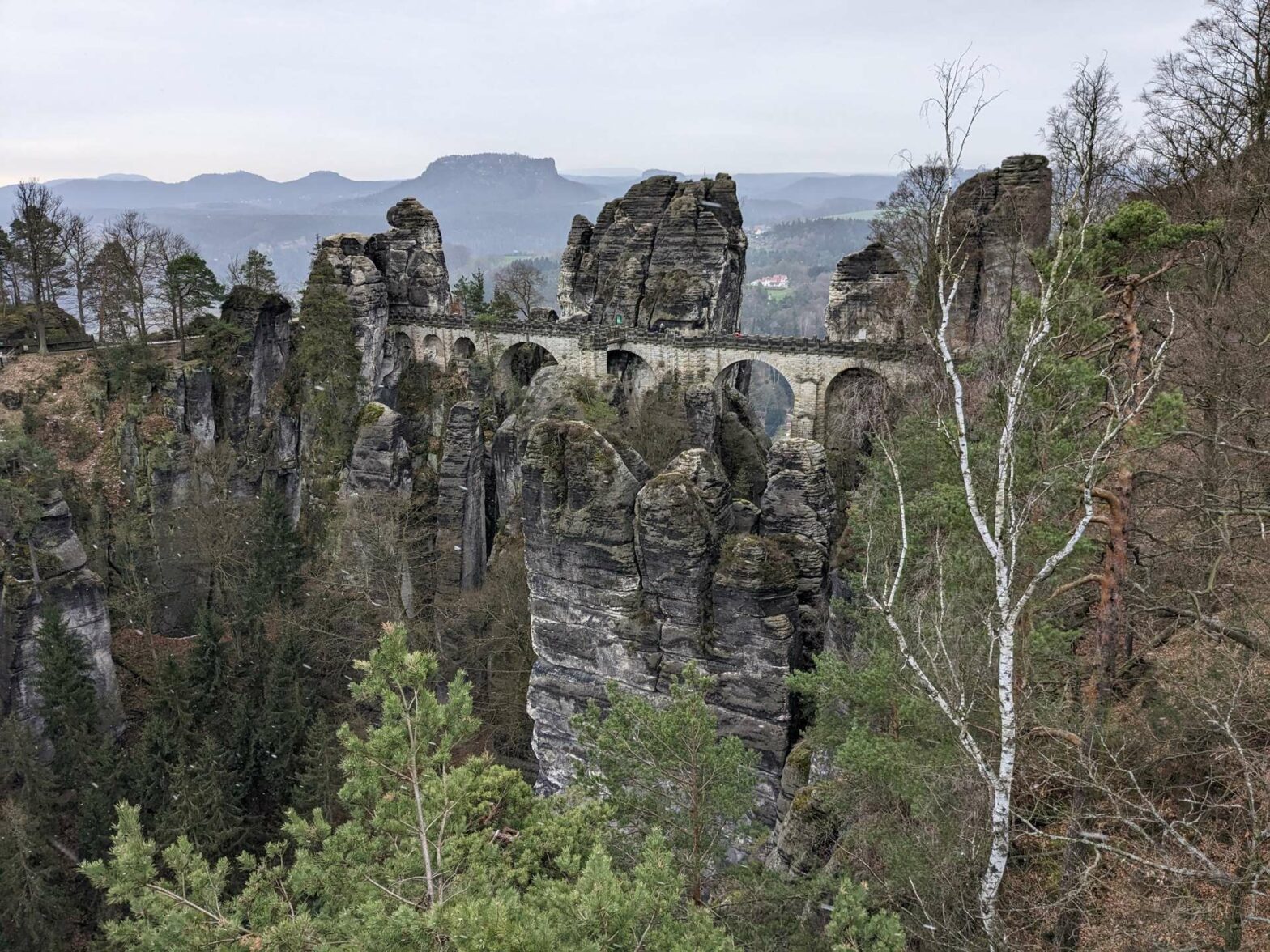
Return back, this time heading right. Again, before reaching the bridge turn left to the best viewpoint of the bridge itself. This is Ferdinandstein Cliff Viewpoint and this is where all the classic photos of the Bastei Bridge are taken from.
Bastei Bridge
Return the way you came and finally turn left to walk across the bridge. Halfway along there’s a mini sticking-out turret where you can take more great photos from. The surrounding scenery is fantastic, so spend a while strolling across and admiring the views.
Continue walking onwards on the other side of the bridge. You’ll soon get to the entrance to Felsenburg Rock Fort, also known as Neurathen Castle. If you want to skip this, keep heading onwards, or to visit the fort turn left.
Felsenburg Rock Fort / Neurathen Castle
Felsenburg Rock Fort, or Neurathen Castle, is open 9am-8pm and costs €2.50/1 per adult/child to enter. It’s not very large but you can see the old ruins of the castle and more amazing views. There are signposts in German and English on the way around, and since you’re here it’s definitely worth seeing.
There’s only one route around the castle, and after about 10-15 minutes you’ll be at the exit. To continue with this hike turn left at the exit, or to return to the Bastei Bridge and car park head right.
Descent to Rathen Village
This is where the downhill to Rathen Village starts. The rest of the hike leads to the bottom, along a small road by a lake, and then back up Schwedenlöcher, a cool rocky gorge. Before you start heading downhill, remember you’ll have to walk back up again!
In a short distance, there’s a little path on the right to Kanapee Cliff View, yet another viewpoint. After this, the path zigzags downwards. You’ll meet a small junction, with the Tiedge Viewpoint to the right around the corner of a huge rock.
After this viewpoint, the hiking trail simply heads downwards through the woodland. In about 400 metres you’ll reach a junction. Turn left here to head down towards Grünbach River rather than Rathen Village.
Grünbach River & Amselsee
When you reach the bottom, turn left along the track by Grünbach River. You’ll soon reach a small dam, the other side of which is Amselsee Lake. Follow the trail all the way to the end of the lake, and continue on the track as it bends left between some narrower cliffs.
Schwedenlöcher Gorge
In a few hundred metres, take the path on the left. There’s a hiking trail sign here, follow the one to Bastei Bridge. As the path leads upwards it becomes steeper and there are many steps. The rocks become closer on either side and you’ll be in the gorge called Schwedenlöcher.
The walk upwards goes quickly, and in no time you’ll reach the flatter area at the top. When you reach a junction in the open area, head straight across to Pavillion Viewpoint. From here there are great views of the landscape, full of tall rocky columns.
Head slightly back into the forest and now take the left path. When you meet a main trail, turn left and you’ll get back to the car park and the end of the Bastei Bridge Hike.
Guidebooks to explore more of the Czech Republic


While in the area, check out the walk up Lilienstein plateau, visit Königstein Fortress, or discover more things to do on our Germany or Czech Hiking Page.
Related Posts


