By Vicky · Published Nov. 9th, 2022 · Updated Aug. 13th, 2023
When you buy through links highlighted with an asterisk (*) on this site, we may earn a small affiliate commission at no cost to you.
The Camogli to San Fruttuoso Hike explores the wonderful scenery of the Portofino Peninsula and ends at a lovely sheltered beach.
Camogli to San Fruttuoso Hike Route Map
Location
This walk starts from Camogli, a small, pretty coastal town. We parked in the Gulliver’s car park, which is €2 per hour. This car park avoids the ZTL (Zona Traffico Limitato) which you aren’t allowed to drive in. It’s also convenient to get to from the highway. You can pay with the EasyPark App (PlayStore, AppStore) or with cash. There’s also a convenient train station in Camogli.

To return from the end of the hike, you can either take a ferry from San Fruttuoso back to Camogli (all year round) or onwards to Portofino (summer only) and from there take a bus and train back to Camogli. Another option is to walk from San Fruttuoso to Portofino before taking a bus and train back to Camogli.
We spent the day hiking from Camogli to San Fruttuoso cove where we had lunch and a swim, before continuing the hike on to Portofino. We then took a bus to Santa Margherita and a train back to Camogli where our car was parked.
Tips
- There are some difficult places where you have to walk across sloping rocks holding onto a chain, so this hike is not suitable for those afraid of heights.
- You must wear decent hiking shoes with grip, take a sunhat and plenty of water for the long stretches with no shade.
- If visibility is poor or the ground slippery, take the alternative hiking route from Camogli to San Fruttuoso (see map↑).
- Continue from San Fruttuoso and hike onward to Portofino for a full day of hiking.
- Offline maps app Maps.me works well for this walk.
- Find other great hikes on our Italy Hiking Page.
Walking through Camogli
Walk out of the car park in Camogli and follow the road around the corner towards the sea. You already have some great views over the cliffs and the harbour of Camogli. When you see a split in the road, take the lower fork leading into the pedestrian area of Camogli. Walk around the harbour and make a quick detour to the church (Basilica di Santa Maria Assunta). It’s rather impressive inside for just a village church. Just opposite is the Castle della Dragonara (closed most of the time) and a viewpoint over the ocean.
Walk back past the church and right along the beachfront promenade. Continue along the walkway and you will reach a street with lots of cars parked on it. The train station is close by on the left up some steps from here. Walk along the street and at the end head to the left of the little stream. Here you should see some hiking signs towards San Rocco and a map of Portofino Natural Park (or Portofino Peninsula).
Camogli to San Rocco Church and Village
Follow the signs to San Rocco, a little village with a church of the same name up the hill from Camogli. The route initially follows along the little rocky stream, then crosses a small bridge and continues upwards. It’s a cute, cobbled path through olive groves with nice views over the countryside surrounding Camogli.
Once you reach San Rocco at the top, you’ve already done a significant amount of the climb on this walk. Immediately you’ll see Panificio Maccarini, a conveniently positioned deli, bakery and cold drinks seller at the beginning of the village. Grab something to eat and drink here, or continue a little further to the right of the church and along the cliff path to Bar Dai Muagetti. This bar opens around 11 am and has fantastic views over the ocean. Reserve if you plan to come at sunset.
Walking onwards from San Rocco
Continue walking along the path overlooking the cliffs, towards the Batterie. There are great views of the ocean, and at the Batterie itself you can head a little way down to some old war bunkers/lookout points.
There’s now a choice in hiking routes. You can either take the main route described here towards San Fruttuoso, or the alternative route. If you are afraid of heights, don’t have hiking shoes with grip, or are afraid of walking across exposed, sloping rocks while holding onto a chain, then take the alternative route. Additionally, if the weather is poor you should also take the alternative hiking route. We did see families with children taking the main route with the chains, but I was very afraid for them and would not recommend it.
Alternative Route in Bad Weather
If visibility is poor or the ground wet and slippery (or you are afraid of heights), it’s unsafe to take the route along the very edge of the cliffs. Instead, take the alternative route from the Batterie Viewpoint. By taking this route, the rest of the walk is 4.8 km with 290 metres climb instead of 3.5 km with 235 metres climb. This means the total length and climb of this hiking route over Portofino Peninsular is slightly more, but the time taken will be similar since the path on the alternative route is much easier.
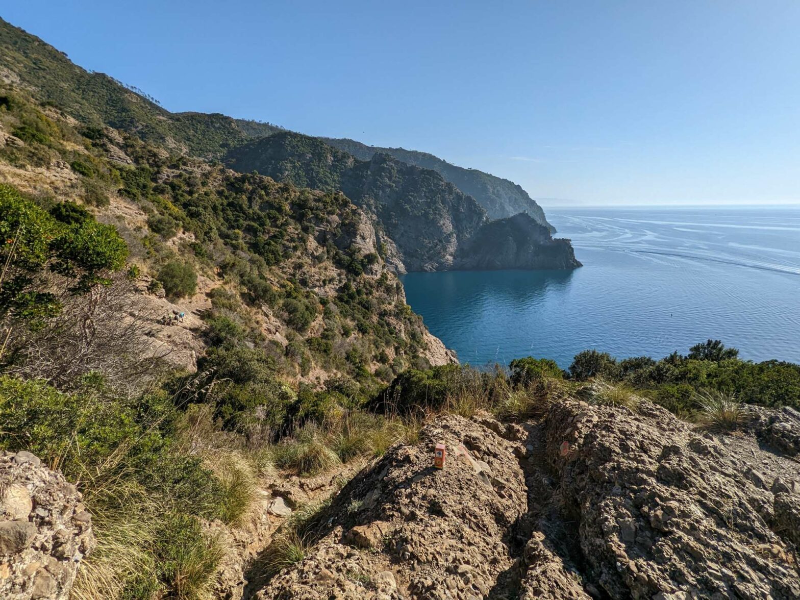
Difficult Cliff Path to San Frutuosso
From the Batterie, the path starts off quite small but easy. Soon you’ll reach the first section with a chain, which is fairly easy. Around the corner, there’s a more difficult section of chains. It’s very exposed and close to the crumbling edge of the cliffs. The next 1.5 km of the route is a mix of easy walking and difficult sections scrambling across the rocks while holding onto the chains. There are really great views all the way and it’s fairly flat.
When you reach the end of an inlet and start heading up again, the chains are over and the rest of the walk is relatively easy apart from the steep climb. Luckily, most of this uphill is in woodland and so shaded. The top of the climb is slightly disappointing as there are no great views from here because of the trees. However, there’s some flat space to take a rest. The route then heads all the way downwards, winding its way through olive terraces, to San Frutuosso.
San Frutuosso
You’ll first glimpse the gorgeous beach of San Frutuosso when you’re fairly near the end of the hike. When we were there, the water sparkled turquoise and we rushed downwards to the beach for a refreshing swim. We used our masks and snorkels as the water was very clear, but there were only a few fish. We also ate some focaccia at da Giovanni. From here we had amazing views out of the window over San Frutuosso Bay.
Of course, there’s also San Frutuosso Abbey to explore (check the opening hours, or Orari di apertura). Tickets are €8 per adult and inside there’s a simple exhibition in both Italian and English.
Continuing Onwards
This is the end of the hike from Camogli to San Fruttuoso. If you want to return to Camogli, the simplest way is to take a ferry directly from San Frutuosso. Alternatively, if you want to visit the cute town of Portofino, you can either walk there (an easy 2-hour walk), or in summer there’s a ferry in that direction.
How to get from Portofino to Camogli
From Portofino, you can quickly return to Camogli. Take a bus to Santa Margherita train station followed by a short train ride to Camogli. Buses leave Portofino every 15 minutes, but the train leaves Santa Margherita only every hour. I’d recommend taking the bus 15 minutes earlier than the one google suggests. This will allow you plenty of time to allow for bus delays and buying tickets at the train station. In busy times, it’s best to get on the bus at the bus station in Portofino car park. This is the start of the route and you might be able to get a seat here, while the bus quickly fills up later.
Guidebooks to explore more of Liguria & Cinque Terre


If you want to get a guidebook to the region, the Bradt Liguria Guide and Lonely Planet Pocket Guide both include sections on Portofino Peninsula. The Cicerone Walking in Cinque Terre Guide doesn’t include Portofino Peninsula but does describe many hikes further south along the coast.
Check out the walk from San Frutuosso to Portofino, or our other walks nearby in Italy.
Related Posts


Proceed on the chain trail with extreme caution. Weather can be unpredictable. No phone coverage. Do not attempt alone .my advice is to take a helmet and ropes as a precaution.
Hi Gerry. I agree that caution is needed on the chain trail, and the alternative easier route over the top should be taken in poor weather. However, I think a helmet and ropes is only needed for inexperienced hikers – who probably shouldn’t be walking the chain trail anyways, or for children.