By Vicky · Published Jan. 4th, 2024 · Updated Feb. 2nd, 2024
When you buy through links highlighted with an asterisk (*) on this site, we may earn a small affiliate commission at no cost to you.
This circular walk at Malham Cove is a classic Yorkshire Dales walk which also features Gordale Scar and Janet’s Foss waterfall.
Parking at Malham Cove
This popular circular walk at Malham Cove starts from the Malham National Park Visitor Centre. There’s a National Park car park just next door, which is £3.50 for up to two hours or £5.50 for over two hours. Unless you walk very quickly with few breaks, you’ll want to stay for over two hours. You can also park here overnight (£6.50). It fills up quite quickly, especially on sunny summer weekends, so arrive early. There are clean toilets by the visitor centre, and a nice exhibition and gift shop inside.
There’s free parking along the side of Chapel Gate Road, on the way into Malham, but it fills up quickly and you have to walk further and further along the road. On very busy days, the local farmers open up their fields for parking (roughly £10 for the day).
Malham Cove Walk Map
Tips
- The limestone pavement at the top of Malham Cove can be extremely slippery – take great care and don’t stray too near the edge.
- Most of this walk is on easy tracks, though it’s a little rocky near Janet’s Foss and can be quite wet – wear appropriate shoes.
- Arrive early to avoid the crowds, especially on sunny weekends.
- For refreshments, there are a couple of pubs and cafes in Malham, and a take-away van selling coffee and snacks by Gordale Scar.
- The map to take for this hike is the Ordnance Survey Map 2 of the Southern & Western Yorkshire Dales*.
- For other hikes nearby, try the walk from Malham Tarn to Littondale, or the short hikes up Beamsley Beacon, Almscliffe Crag, Sharp Haw and Flasby Fell, or Embsay Crag.
- You can find other Yorkshire ideas in our Yorkshire Guide.
Malham Cove Walking Route

From the Malham National Park Visitor Centre, walk along the road towards the village. At the little roundabout by the Buck Inn, continue slightly left along the road. After about 50 metres you’ll see a thin section of woodland on your right. Go through the gate and walk through the trees alongside a small stream. Walk to the end of the wood, then continue along the road.
The road heads slightly upwards and past a small collection of stone houses including an old barn on your right. Just after this, you’ll see a walking signpost pointing towards Malham Cove. Head through the gate and follow this path through the field.
Walking to Malham Cove
You’ll already have good views of Malham Cove in the distance. The easy trail continues through a gate in another wall and down towards the small stream. This is Malham Beck, one of the tributaries of the River Aire which starts just the other side of Malham. Continue walking and before the rockface, you’ll see a path heading upwards to the left, as well as a path continuing towards the Cove.
To see the very bottom of Malham Cove, where the stream comes out beneath the cliffs, head onwards and through the little wooden gate. On the other side of this gate, the path becomes quite rocky and can be slippery and a little tricky. You can only continue about 50 metres or so until you reach the base of the huge cliff.
Malham Cove: A Shorter Walk
If you would like a shorter walk, the route to the bottom of Malham Cove and back is 1.5 km each way, and fairly flat. If you want to continue to the top, there’s 75 metres of height gain up many stone steps.
Retrace your steps to cross back through the gate, and head right. This path leads up to the top of Malham Cove and contains many stone steps. Take a few breaks on the way up to admire the view behind you and catch your breath.
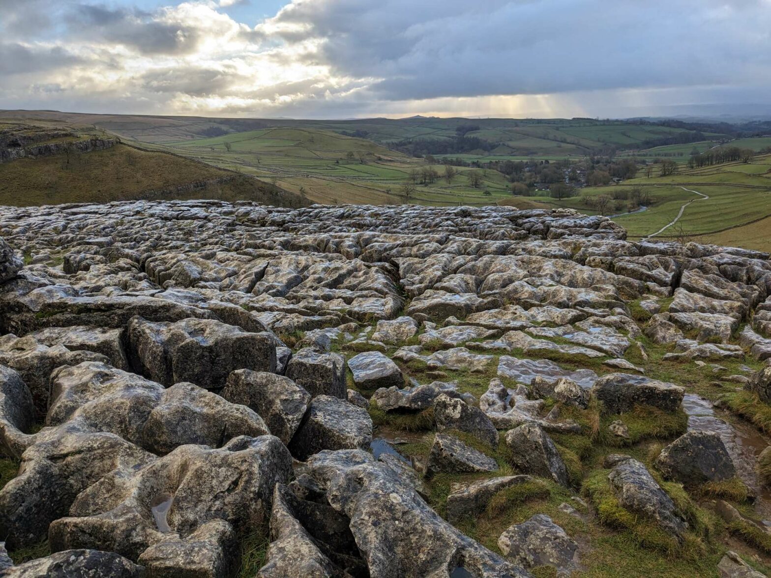
Once you get through the gate at the top of the steps, you’ll see some wonderful limestone pavement to your right. It’s quite tricky to walk across and can be very slippery. If you want to avoid it, follow the path to the left along the wall and then head right above the rocks.
If you want to walk across the limestone pavement at the top of Malham Cove, you can do so. Take care and don’t go close to the edge. Did you know, a scene from Harry Potter and the Deathly Hallows was filmed here? Harry and Hermione chat on the limestone pavement, with the valley and Malham village in the background.
Walking to Gordale Scar
Once you’ve explored the limestone pavement, head across the top and down into a little, dry valley. Turn right at the wall and left through the gate onto the grassy path. Follow the path as it leads gently downwards to a small road. Cross over, and continue on the track on the other side.
This track leads around the hillside, above some fields. You have great views from here over a cute valley in the distance, with little fields and a small lane leading up the centre. Soon the path heads right, through a wall, and down a grassy slope. At the small lane at the bottom you’ll see a van selling coffee and snacks. Turn left on the lane and just around the corner take the obvious path to your left.
From here there’s an easy out-and-back walk of 600 metres each way to Gordale Scar. This is a dramatic limestone ravine and waterfall and it’s definitely worth the detour. First you walk through a grassy field, which is a campsite in summer. There’s a stream to your left, and the valley gets narrower and narrower.
After a few hundred metres, you suddenly round a corner and reach Gordale Scar, with towering limestone cliffs above you. The waterfall is at the far end. It’s a scenic place to have a picnic, though it can be damp and cold unless it’s a warm day. There’s actually a walking route that leads up (or down) the waterfall, which involves clambering up the rocks between the two water streams.
Gordale Scar to Janet’s Foss
Once you’ve enjoyed the waterfall, return the way you came back to the lane. Continue down here, past the food van and about one hundred metres further. You’ll see a walking sign and a path leading left, to Janet’s Foss waterfall.
The waterfall isn’t far away, it’s just down a short rocky section of path. There’s a large pool at the base of Janet’s Foss which is popular for swimming, but is very cold all year round! The waterfall itself is a few metres high and quite wide, with water rushing quickly over the top.
After the waterfall, continue along the riverside path through the woodland. You’ll soon leave the trees behind and be walking through grassy fields. It can be very muddy and wet here, so hiking boots are recommended in winter. The path turns right just before a stream, about 1 km after you leave the woodland.
Now you head directly back towards Malham village. A few hundred metres later you’ll see a ford through the stream on your left. If it’s dry you can cross here, but often it’s wet and you have to cross over the little stone bridge a short distance later. The car park, and the end of the Malham Cove Circular Walk, is just to your left.
Guidebooks to explore more of Yorkshire


The Rough Guide to Yorkshire* is a great little guidebook and has a section on Ilkley and things to do nearby. The Yorkshire Dales Pathfinder Guide* has a good collection of short hikes suitable for the entire family and the Guide to North Yorkshire Pub Walks* has some fun walks in the Dales for those who are hungry and thirsty.
For other short countryside hikes nearby, why not try the walk from Malham Tarn to Littondale, or walk up Almscliffe Crag, Sharp Haw and Flasby Fell, Beamsley Beacon, or Embsay Crag.
Related Posts


