By Vicky · Published Mar. 6th, 2021 · Updated Nov. 23rd, 2022
This one-way hike crosses Table Mountain, from Constantia Nek to Deer Park. You get amazing views over both Constantia region and Cape Town centre. This trail goes up, along, then steeply down towards Deer Park, where you can satisfy your hunger and thirst at an array of local eateries.

Location
This hike starts at Constantia Nek parking, just by a busy roundabout. It takes about 20 minutes to get here from Cape Town centre. Since this hike is one way, you will need to uber to get back to where you started. It’s possible to do this hike the other way around, from Deer Park to Constantia Nek. This would involve a very steep and long climb at the beginning, then flat and downhill the rest of the way. The way we hiked it, from Constantia Nek to Deer Park, the trail starts off quite uphill, followed by flat and more sections of uphill. Then it ends with a long and steep downhill.
Constantia Nek to Deer Park Hike Map
Get the route by downloading the .gpx or .kml file below. For navigation with Maps.me on your mobile phone, simply download the .kml file and open to add it to the Maps.me bookmarks.
From the car park at Constantia Nek, take the track on the right, by the edge of the buildings (i.e. not the Orange Kloof Trail for which you need a permit). This track heads upwards, and you pass through a boom onto a wide, dusty trail.
Tips
- It can be very hot in the middle of the day, even in winter. It’s best to start this hike early, so you do the climb in the cool of the morning.
- This hike is one way, so you will probably need to uber back to where you started.
- At the top of the cable car, refreshments and toilets are available.
- You can shorten this hike, and save your knees somewhat, by taking the cable car down. Tickets can be bought at the top.
- There are some great places to eat and drink near Deer Park, for example on Derry Street down from the KwikSpar.
- This hike could be done as a run, but make sure to still take enough water.
- Hiking Poles* can really help to reduce pressure on your knees
- Discover more hiking ideas in our South Africa Hiking Guide.
Almost immediately, take the smaller trail heading upwards on your left. There’s a mix of steps and a dusty/rocky path.
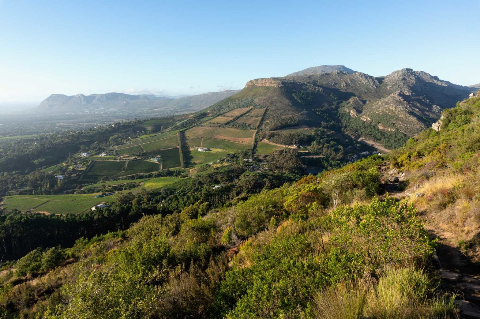
You hike quickly upwards, gaining height rapidly. This brings you splendid views over the beautiful wine farms below.
The trail joins a bigger, paved track, which you follow round a steep turn before again taking the smaller trail heading upward on the left. You hike along, paralleling the paved track below, before meeting it a kilometre later. Following this paved track still upwards, you suddenly reach the flat plateau on top of the mountain.
On the mountain plateau above Constantia Nek
If you pop down a little trail for a few metres, you can see Devilliersdam Reservoir, which for us was brilliant blue in the bright sunshine. Back at the main trail, continue along past a couple of houses. These must have the best views in Cape Town.
As the track rounded a corner, we continued straight on, onto a smaller trail. We then turned left at number 5 on the Slingsby maps (see photo above), between Reserve Peak and Cleft Peak. We took this route to pass through a beautiful little woodland (see below), and to see the reservoirs. If you wanted to cut a couple of km of this hike, you could instead continue straight on at point 5.
The woodland on the way to Hely-Hutchinson reservoir was very cute. There were many gnarly old oak trees along with a wonderful smell of damp leaves.
We turned right to walk in between Woodhead and Hely-Hutchinson reservoirs. The path led alongside the huge, curving dam wall, which gave us some cooling shade. At the far end of a wall, is an old waterworks museum.
We continued straight on, onto a smaller path, to loop around Junction peak. The trail led up a small valley, with some large rock steps. This trail rounded a corner and turned into a funny little walled path. We saw many beautiful red disas here. The trail then led us back onto the path along the edge of Table Mountain plateau.
Flora
In late summer/early autumn, beautiful disas bloom on Table Mountain. Disas are a type of orchid, and there are many different types. Little blue disas can be found along the front of Table Mountain. The large red disa lives in shady streams, which you pass on this walk.
Proteas can be seen in bloom almost any time of year.
The path continues gently upwards, and soon we were at Maclear’s Beacon, the highest point on Table Mountain.
History
Table Mountain is 1086 m high. This spot is marked by Maclear’s Beacon, which is the highest point on Table Mountain. It was built by Sir Thomas Maclear in 1865. However, it wasn’t actually built to mark the highest point, but to assist with surveying the curvature of the earth. Some people had calculated that the earth was pear-shaped, others thought it must be round like an apple.
Sir Thomas Maclear also set about measuring distances all over South Africa, which improved the accuracy of maps.
Views from the top
Maclear’s Beacon is slightly set back from the front edge of Table Mountain. To get the best views, take the trail that leads along this front edge. You have to backtrack a few meters to take the path around the side of the beacon, to the edge. Be careful when walking along here, especially if it’s slippery. Two wrong steps and you could fall a very long way. If you’re afraid of heights, there’s an alternative route from Maclear’s Beacon, which continues straight on from the Beacon itself.
Continue along this flat top, until you reach a little gorge, with a signpost. We headed onward to the cable car station. If you want to head down straight away to save 1 km, turn right to Platteklip Gorge. We visited the cable car station to see the views over Camps Bay, and to make use of the toilets. There is also a café here, where you can buy refreshments.
Fauna
You’re most likely to see butterflies and birds. There is a special type of butterfly, called Table Mountain Beauty, or Mountain Pride. It’s quite common and mainly brown and orange. Despite its name, it is a lot more widespread than just Table Mountain. Sunbirds and sugarbirds are common since they love the proteas. Sunbirds have curved beaks, while sugarbirds have long tails.
If you’re lucky, you might see klipspringer, a small antelope. They love perching photogenically on rocks.
Walking Down Table Mountain
Return back to the little gorge with the signpost. I always get confused in this region, it’s easy to get disoriented. Make sure you take the correct path down, to Platteklip Gorge. This route involves many stone steps, some of which can be slippery. There is no shade, and not much breeze, so it can be very hot. But at least you aren’t hiking upwards! My legs are always shaky when I reach the bottom of Platteklip. If you have dodgy knees, you might opt to take the cable car down.
We turned left to head along the upper contour path for a few metres, before taking a smaller trail heading down to Tafelberg Road. Once at the road, a track continues almost opposite where you come out. It’s still steeply downhill, towards the trees of Deer Park.
Once we reached the car park at the lower end of Deer Park, we took a right just before the tarred road, to continue along just above the buildings. We passed just above Disa Towers, then took the first left down through a little residential area, to come out close to the Vredehoek Kwikspar. This Spar is one of the best supermarkets in the world (in my opinion). Further down the road from the Spar are some cafes and restaurants. We had pizza at Carlyles, but can also recommend the Red Sofa Café.
Once you’ve satisfied your hunger, uber back to the starting point after your long hike from Constantia Nek.
If you enjoyed this walk, try hiking up Devil’s Peak, Little Lions Head, or around Silvermine Reservoir. For even more hiking ideas, check out our South Africa Hiking Guide.
Related Posts


Followed most of your route, except for exiting Deer Park on Molteno, and following that all the way down and through the Company Gardens. Had a lot of fun, thanks!