By Vicky · Published Feb. 19th, 2023 · Updated Mar. 23rd, 2023
When you buy through links highlighted with an asterisk (*) on this site, we may earn a small affiliate commission at no cost to you.
The hike up Pürschling & Teufelstättkopf Peaks is a relatively easy walk with great views, possible in both summer and winter snow.
Pürschling & Teufelstättkopf Hike Map
Get the route by downloading the .gpx or .kml file below. For navigation with Maps.me on your mobile phone, simply download the .kml file and open to add it to the Maps.me bookmarks.
Location
This hike starts from Parken Pürschling, a fairly large car park just to the west of Unterammergau. It’s about 1hr10 drive from either Munich or Augsburg. Parking costs €5/€7 for 4hrs/all day. You probably need more than 4 hours, unless you hike very fast. Payment is via cash or the EasyPark App. Alternatively, the train from Munich takes about 1hr40 and the start of this hike is about 15 minutes walk from the station in Unterammergau.
Tips
- There is a hut near Pürschling Peak (August-Schuster-Haus) which serves food and drinks, open May-October,
- If hiking in winter snow, hiking poles* are very useful as are crampon micro-spikes*. Particularly, the trail near the beginning can be quite icy, and we wore our micro-spikes almost the entire route. If there’s been a lot of recent snow, snowshoes* could be useful, though it’s a fairly-well trodden route.
- The route described below, heading clockwise, is the best way in the snow as you’ll be walking up in thinner snow, and walking down in thicker snow.
- For more hikes, check out our Germany Hiking Page.
Pürschling & Teufelstättkopf Peaks Hiking Route

From the car park, head along the track heading upwards and keep left. This section of the track can be very icy if it’s snowed and then melted a little before refreezing. Crampon micro-spikes* will make your life a lot easier if this is the case. If there’s been recent heavy snow, snowshoes* would make this section easier as the snow can get quite deep.
The track heads fairly steeply upwards through the forest near a stream. You’ll pass a couple of forest huts and a few religious statues on the way. There are several hiking signs on the way, follow the ones to Pürschling Peak and August-Schuster-Haus. About two-thirds of the way up you’ll reach Josefs Kappele, a small pink chapel in the mountains. There’s a great bench here where you can relax and admire the view.
Continue upwards along the track, and soon you’ll leave the forest and enter an open area. The August-Schuster-Haus hut will be in sight at the top of the ridge, and it’s not too much further to walk. Once at the top, there are several viewpoints. First head slightly to the left to an obvious little rocky mound by a fence. From here you can see all the way down to the valley, and up to the rocky top of Pürschling Peak on your right.
Pürschling Peak & August-Schuster-Haus
After this viewpoint, you can head towards Pürschling Peak. If you don’t want to go to the very top (slightly rocky and vertigo-inducing), you can walk just to the right of it and there’s another great viewpoint from there.
Walk up to the hut itself and round to the front for some more views. There’s a bench here, sheltered from both the wind and rain, a nice spot to take another break. If the hut is open, treat yourself to kaiserschmarrn (fluffy cut-up pancake) or topfenstrudel (quark strudel, super delicious) and a large hot chocolate.
If the weather is bad or there’s too much snow, head back down the way you came as this is the easiest route. The next section of the hike is on smaller paths, and it can be slippery and narrow in places. If it’s dry and sunny there are no real problems, but in the snow it could be slightly scary – micro-spikes really help.
Hiking to Teufelstättkopf
Leave the hut and turn left, now following the hiking signs to Teufelstättkopf. The path zigzags upwards through fields and forest to reach the ridge. The path continues gradually upwards until you reach a rocky area and a junction. Turn left, still following the signs to Teufelstättkopf. When we were here (mid-Feb) most of the snow had melted from this top section, and we removed our micro-spikes for a few hundred metres, till just after the top of Teufelstättkopf itself.
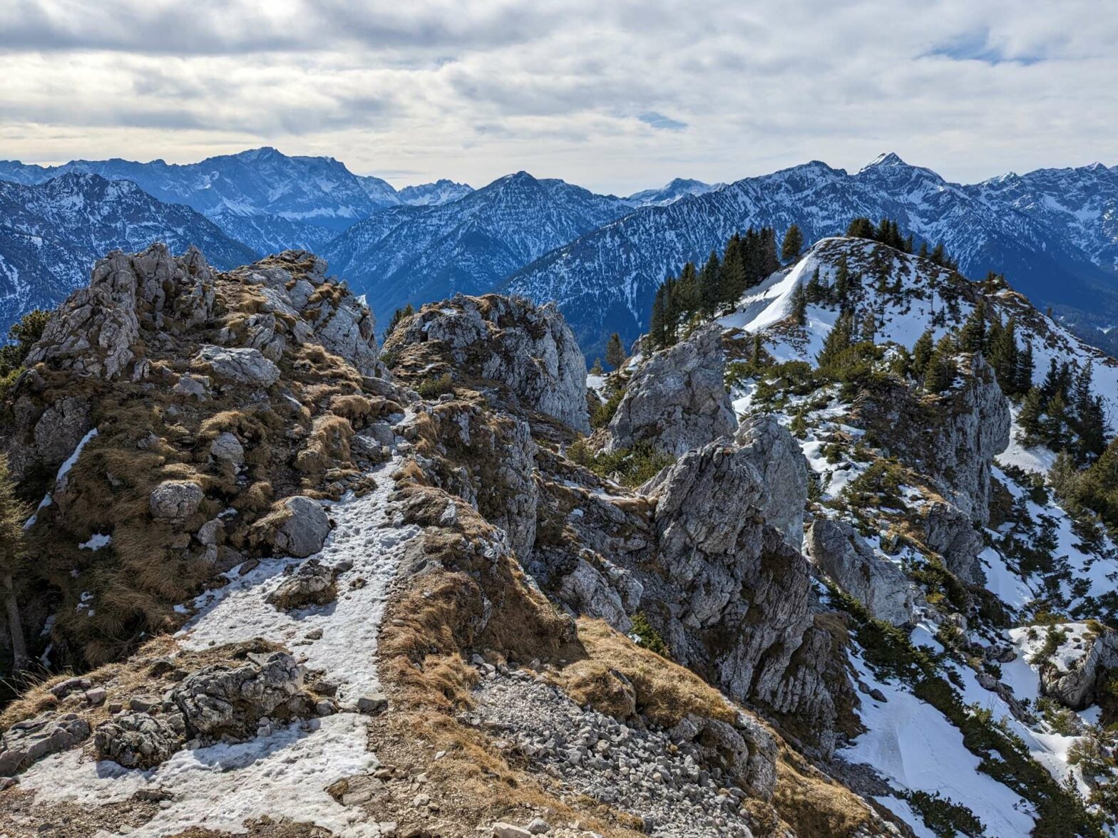
This rocky area is very beautiful and there are great views all around. The path wiggles through the rocks and soon you reach the short out-and-back to Teufelstättkopf peak. You can leave your bags here, or take them with you if you plan to have lunch at the top, though it can be quite windy at the peak.
There is a thick metal cable to hold onto all the way up to the top. It’s not technically difficult, but you should have a steady footing and not be afraid of heights. If you don’t want to walk to the very top you aren’t missing out on too much because you can already see the views from where you are.
Walking back down
Once you’ve returned from the rocky peak, remember to collect any belongings you left at the base, and continue on the path heading right. The next few hundred metres can be slightly tricky if it’s slippery as the path is narrow and a bit steep in places. You walk along a beautiful little ridge, perhaps the best part of the hike, heading gradually downwards with great views towards the valley at the bottom.
In not too long the hardest part is over and the path continues to descend as the ridge widens. After a while you reach the treeline and head back into the forest. The descent continues and leads into a large open field. The path heads steeply down to the ridge here, towards a couple of small huts called Kuhalm and a track.
Turn right at the track and continue to walk downwards until you reach a little circular lake. Head left here and the track wiggles back to join the track you walked up on. Head downwards for about 500 metres to a sign and some steps leading off to your left. Take this route instead of the main track, and you’ll walk by a lovely little stream with several waterfalls (called Schleifmühlklamm, or Grinding Mill Gorge).
Soon the path becomes a track, and turns into a road through a couple of houses. You’ll reach a junction, and the car park if just to your left. This is the end of the Pürschling & Teufelstättkopf Peaks Hike.
Guidebooks to explore more of Germany


For another walk in the snow, try the walk to Kenzenhütte, climb the Seekarkreuz Peak or hike up Wolfkopf Peak. For an easy walk nearby, stroll around near the Wieskirche. Alternatively, check out our Germany Hiking Page for more great hikes nearby and for walking tours of the famous Bavarian cities.
Pin it
Related Posts


