By Vicky · Published Dec. 10th, 2022 · Updated Mar. 23rd, 2023
When you buy through links highlighted with an asterisk (*) on this site, we may earn a small affiliate commission at no cost to you.
The hike up Seekarkreuz is a relatively easy walk that brings high rewards with a fantastic Alpine panorama at the top. It’s a popular route both in summer and winter, and passes a lovely mountain hut near the top.
Get the route by downloading the .gpx or .kml file below. For navigation with Maps.me on your mobile phone, simply download the .kml file and open to add it to the Maps.me bookmarks.
Location
The Seekarkreuz Hike starts from the Wanderparkplatz Ruine Hohenburg just southeast of Lenggries, about 1 hour’s drive south of Munich. You have to pay €3 for parking for up to 6 hours (enough time for this hike), and €5 for longer than 6 hours. Slightly further just across the bridge is another parking that’s only €2 but this fills up quickly. Alternatively, you can park a few hundred metres back on the edge of the road opposite the school.
Tips for Seekarkreuz Hike
- There’s a mountain hut near the top serving food & drinks. From Nov-Apr it’s closed on Mon & Tue.
- If hiking in snow, hiking poles* are essential as the route is well-trodden but slippery in places. Crampon micro-spikes* would also be useful. I bought some after this hike as I was very jealous of the people with these, who had no trouble at all with the slippery path.
- For more hikes, check out our Germany Hiking Page.
Seekarkreuz Loop Hiking Route

Head north out of the car park and turn right along the small road. There’s a posh-looking, very long farmhouse on your left, with a very cute chapel on the grounds. The tarred road soon turns into a gravel track and you’ll pass some more cute houses and farm buildings in the fields, with the mountains rising up behind them.
Continue walking along the track and you’ll soon enter the forest. The track now heads gradually upwards alongside a stream. Roughly 3 km from the beginning, turn right up a track just before a bridge, signposted towards the Lenggreiser Hut. A few hundred metres later, take the path straight onward rather than following the track around the bend.
The Steep Path Upwards
The path is now narrow and can be muddy. The incline increases, and in a short distance, you’ll start a long series of switchbacks heading steeply upwards through the wood. The zigzags seem never-ending, but suddenly you’ll come out of the wood into a large open area. In summer it’s a grassy meadow, while after snow it’s a winter wonderland.
After a short distance walking on the path through the open area, you’ll reach a larger track. Turn right to follow it along to the Lenggreiser Hut, at the far end of the open. This track is the main supply route for the hut, so even in winter there are many vehicle tracks along it and it’s a very clear route.
Lenggrieser Hut
The Lenggrieser Hut is open every day in summer, but from November to April it’s closed on Mondays and Tuesdays. The hut is also closed for a couple of weeks in the winter, check here for dates (in German).
The Lenggrieser Hut has a really great position and a fantastic view from the outdoor seating area. You can stop here now, or when you return from hiking to the top of Seekarkreuz as the route comes back here. We chose to head to the top first.
Hiking to the Top of Seekarkreuz
From the hut, the trail to the top of Seekarkreuz leads past the small children’s play area before heading upwards and into the forest. There’s a signpost here, just follow the route to Seekarkreuz. There are a couple of viewpoints in the wood, and soon you’ll leave the trees into an open area near the top of the mountain.
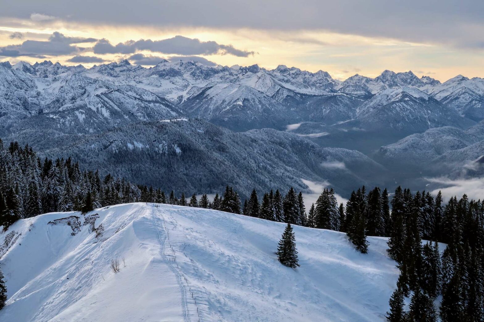
A little way into the open, at the top of the ridge you’ll reach a path junction. There are some really great views from here, so take some time to enjoy them. You can already see the cross at the top of Seekarkreuz peak, so turn left to walk to the top.
The top of Seekarkreuz is 1601 metres high, not that high for the Alps, but from here you have a terrific panorama over the higher mountain ranges to the south. To the north, you can see the flat plains of Germany, though when we were there this region was fully covered in low-hanging mist. If it’s not too cold, it’s a great place to sit for a while and eat some snacks.
When you’ve finished admiring the view, head back down the way you came to Lenggrieser Hut. In winter, the path seems a lot more slippery on the way down, so take care.
Back at the hut, we ordered hot chocolate and apple crumble, both coming with a lot of whipped cream. We sat outside to look at the view, but inside it was extremely hot if you want to warm up.
Other Hikes in the Snow


Walking back Down
The route back down starts just after the playground and heads right on a small path through the trees. Again, this section can be slippery in winter so watch your step. After a steep initial down, the path flattens a little, then continues downwards. After a while, you reach a forest track, on which there are several nice viewpoints.
In not too long, the track leaves the forest and enters some open fields. Keep walking along the track, and soon you’ll enter the little farming village of Mühlbach. There are many cute houses in this village and many long half-wooden farm buildings. After a short distance further, you’ll cross a bridge and be back at the car park where you started. This is the end of the Seekarkreuz Peak Hike.
Guidebooks to explore more of Germany


If you enjoyed this walk, check out our Germany Hiking Page for more great hikes nearby and for walking tours of the famous Bavarian cities.
Pin it
Related Posts


