By Vicky · Published Aug. 1st, 2022 · Updated Mar. 23rd, 2023
When you buy through links highlighted with an asterisk (*) on this site, we may earn a small affiliate commission at no cost to you.
The Oberstaufen to Immenstadt Ridge Hike is a one-way day walk along an undulating ridge with lovely Alpine scenery.
Get the route by downloading the .gpx or .kml file below. For navigation with Maps.me on your mobile phone, simply download the .kml file and open to add it to the Maps.me bookmarks.
Page Contents:
Location
The Oberstaufen to Immenstadt Ridge Hike starts at Oberstaufen train station and ends at Immenstadt train station. From both these stations you can reach Munich in 1.5-2 hours.
Tips for Oberstaufen to Immenstadt Ridge Hike
- Bring swimming stuff if you want to swim in the pools
- This hike could easily be hiked the other way around, then the pools are near the end.
- We used the Kompass Allgäuer Alpen Map* for this hike.
- You can shorten the hike by 8 km by taking a bus (see box)
- Offline maps app Maps.me works well for this hike.
- For a gorgeous nearby overnight hike, try the Kemptner Hut and Großer Krotenkopf route.
- Find other great hikes on our Germany Hiking Page.
From Oberstaufen train station head out to the bus station and left through the car park. Walk along the minor road next to the railway and cross beneath the highway in a tunnel. On the other side continue a short distance before taking the small path right into the forest. Walk left on the main forest track as it continues to Bad Rain Hotel and Restaurant.

Follow the signs to Buchenegg and continue along the minor road past the hotel and around the bend. The route then starts heading uphill through a forest. At the top of a hill you reach a plateau full of farmland and cute Alpine farmhouses. Turn right along the road in the little village of Buchenegg.
Shortening the hiking route between Oberstaufen and Immendstadt
If you want to miss 8 km off the beginning of the hike, you can take the bus from Oberstaufen train station to Lanzenbach bus stop. It’s then only 500 metres to the start of the climb up the ridge, rather than 8.5km. This will save you at least two hours. Lanzenbach bus stop is just 650 metres before Hochgratbahn (a cable car station), which is where the buses go to. Bus Line 95 is the one to take. Buses leave the train station at 8:35, 9:35 and 10:45. Check the bus timetable for the most up-to-date times.
If you’re tired near the end, instead of summiting Immenstadt Spitze you can turn right at Seifenmoos. Instead of the described route, which from Seifenmoos is 6.5 km with 250 m up and 850 m steep down along a small path, it’s 5.2 km with a fairly gentle 600 m down and no uphill along a road.
After a little while the road bends sharply to the left and starts heading uphill. Soon you’ll reach a car park with a toilet. This is the main place for people to park who just want to head to Buchenegg Wasserfälle (Waterfalls) and back.
Buchenegg Waterfalls
From the car park, a small path heads steeply downwards through the forest. Unfortunately, you lose most of the height you’ve previously gained which is slightly depressing. Watch out for views of the double waterfalls as you walk downwards – you can’t see them both at the same time from the bottom.
Cross the river on a suspension bridge and head left on the other side. Before taking the trail on the right heading upwards, continue a short distance further to reach Buchenegg Waterfalls. You’ll come to a little beach area and some rocks. The pool below the waterfall looks gorgeous for swimming, but we’d just started our hike so didn’t go in. Others did, even though it was quite cold.
The Other Side of the River
Leave Buchenegg Waterfalls and head up the small path to leave the valley. There’s quite some uphill, but not as much as you came down on the other side. At the top of the woodland take the track to the left into some fields. We saw some cows here, and if you look around there are many cute Alpine barns and fields. There’s also a good view up the valley to the high ridge beyond.
Keep straight on, then take the signed path heading left and downwards through some fields. There are some lovely wildflowers here, and soon you reach a bridge with a scenic picnic bench next to the river. Cross the river and head right to the next bridge.
The Climb up to the Ridge
From the bridge at Holzerhütte (the old barn), continue onwards and take the next path on the left, signposted Prodel. It’s a small path, but clear and easy. It winds its way up the mountainside to the top of the ridge. When we were there we picked many wild raspberries from the bushes by the path.
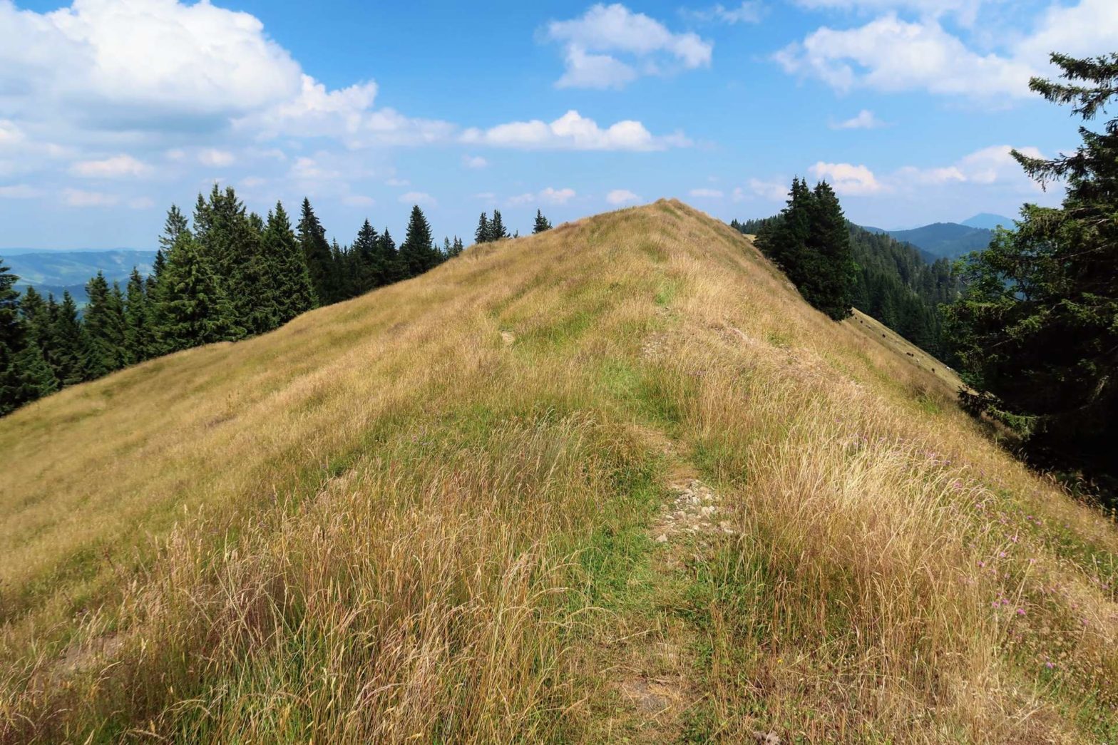
After about 300 metres of climb you’ll leave the forest into an Alpine meadow. In a short while there’s a bench with scenic views, the perfect place for a break and perhaps lunch. The path heads left up the slightly rocky, grassy ridge from the signpost just after the bench.
Reaching Prodel Peak
The path continues to head upwards at the top of the ridge, on the edge of the forest. There are great views to the right of the higher ridge, and down to the valley below. About 1.5 km and 200 meters climb after the bench, you’ll reach Prodel Peak. The peak isn’t that higher than the surrounding ridge so there isn’t much special there.
The walk continues onto a track through some open fields. The track heads slightly downwards towards a farm, and at the corner a smaller path leads off to the left from a signpost. This path leads fairly steeply upwards through another field. At the top you reach a really nice section of ridge – flat, with wildflowers and great views on either side.
Walking through the Forest
After this, the walk mainly continues through forest. Walk onwards and take the track heading left to keep going along a ridge. There’s a nice viewpoint at Eckhalde, a clearing between the trees with a large cross. The path continues back into the trees behind the cross. 400 metres later, the path bends 90 degrees to the right and starts heading downwards through some nice forest.
Turn left when you reach a track, and then right to cross a bridge over a stream with a view. The track winds around and you start heading gradually upwards again. Soon you’ll pass Rosshütte, a mountain hut by the path (being repaired in 2022). After the hut you reach an open area and turn left at a junction in a field towards Seifenmoos Alpe (two houses).
Hiking Seifenmoos to Immenstadt Spitze
Once you reach the road at Seifenmoos, turn left to walk along the road and up to Immenstadt Spitze. To shorten the route, head right down the road (see box).
The road heads gradually upwards towards Kemptener Naturfreundehaus, also known as Berg Briada. Food is available Tue-Sat 10am-5pm and Sunday 10am-3pm, drinks available for an hour later and until 10pm on Friday and Saturday. We were too late for a refreshing drink here, and continued on a path heading right from the hut.
The route descends down to a farm before heading back upwards for the final climb of the day to Immenstadt Spitze. It’s quite steep up through some fields before reaching a wooded area just before the summit. From the stop of Immenstadt Spitze you can see down to the Großer Alpsee below, and far beyond. There’s an emergency shelter hut here along with a picnic bench and a big cross.
Descending from Immenstadt Spitze
From the top, take the path heading down through the wood towards Immenstadt town. After a while you’ll reach a track and head left, then soon right. At the next corner, the hiking path heads off to the left. It’s slightly slippery in places, but there are metal chains to hold onto at the worst parts and it’s not difficult. There are some views through the trees, and eventually you’ll reach another hiking path.
Turn right on the path to a road. At the road turn left, and walk down the narrow path next to the concrete road barrier towards the cemetery (Friedhof). After the road turns the corner, head straight on, past a church and a large yellow mansion (Villa Edelweiss). Cross over the bridge across the railway and Immenstadt station is a few hundred metres on your left. This is the end of the Oberstaufen to Immenstadt Ridge Hike. You can take the train back to Oberstaufen, or head in the other direction to Munich and beyond.
Guidebooks for Hiking in the Alps


If you enjoyed this hike, why not try an amazing overnight hike in the area to Kempter Hut and Großer Krotenkopf, or other hikes elsewhere in Germany.
Pin it
Related Posts


