By Tom · Published Sep. 22nd, 2021 · Updated Nov. 24th, 2022
The famous Cape Point has much more to offer than just the viewpoint of the lighthouse at the end of the peninsula. This loop hike starting at Cape Point takes you also to Cape of Good Hope and the idyllic Platboom beach. On the way back you traverse a hill with splendid views overlooking the whole peninsula.
Location
Cape Point is a section of Table Mountain National Park. The entrance gate to this section of the park is about 1-hour drive from the centre of Cape Town, and it takes another 20 minutes to drive to Cape Point. There is a large car park at the start of this hike, just by the funicular. If you don’t have a car, check out the options for car hire* from Cape Town. We revisited Cape Point in February 2021 for this hike.
Cape Point Loop Hike Map
Get the route by downloading the .gpx or .kml file below. For navigation with Maps.me on your mobile phone, simply download the .kml file and open to add it to the Maps.me bookmarks.
Tips for Cape Point
- Cape Point is part of Table Mountain National Park.
- The entrance gate hours are 06:00 to 18:00 from October to March and 07:00 to 17:00 from April to September.
- Adhere to the closing time indicated at the gate to avoid having to pay a fine.
- Entrance fee: Free for WildCard holders, R85/40 for South Africans, R340/170 for foreigners (adults/children)
- On warm sunny days, swimming in one of the tidal pools is an excellent way to cool off after the hike.
- Sunhat, sunscreen and water are needed in sunny weather.
- The path is quite straightforward, but some navigation is needed away from Cape Point. For instance, use offline maps app Maps.me.
- We did this hike on a day trip to Cape Point as the first of two hikes, find the second one up Kanonkop here.
- Check out our Cape Point Guide for all other things to do in the park.
The views from the car park towards Cape of Good Hope are already quite stunning. The fynbos-covered ground sloping towards the cliffs and ocean with azure blue water is quite magnificent, especially when a herd of eland pops up for their occasional visit.

Cape Point
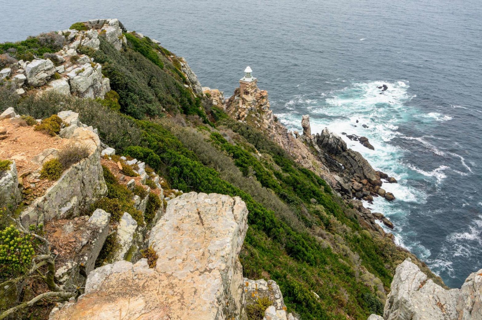
First we visited Cape Point, the busiest section of this hike and of the whole park, but for good reason. However, when we visited we had the place to ourselves due to the lack of foreign tourists in South Africa because of the Covid pandemic. If you want a shorter hike that just visits the lighthouse, check out our Cape Point Lighthouse Hike.
There are many viewpoints along the way to the first lighthouse, which is the highest point of Cape Point. After enjoying the views we continued towards the viewpoint of the second lighthouse. To get there, take the small gated path starting behind the upper funicular station.
After an initial zig-zag descent, the path takes you along the ridgetop towards the very point of Cape Point. The views from the last viewpoint are quite stunning. After a little snack break, we returned the way we came, all the way back to the car park.
Geology of Cape Point
The geology of Cape Point can be split into three distinct layers:
- At the top, above 65 meters, is the Peninsula Formation, which is very similar to the upper layer of Table Mountain. It consists of quartzitic sandstone with occasional shale layers.
- From about 15 meters above sea level, the Graafwater Formation starts, consisting of reddish-looking sandstone and shale beds. The shale layers are relatively soft and erosion has created deep overhangs and sea caves.
- The base is the immensely hard Cape Granite, consisting of molten rock with clearly visible white rectangular crystals, called feldspar.
Cape of Good Hope
We continued our hike from the car park to Cape of Good Hope. The trail starts next to the ablutions block. Along the way, there is an optional out-and-back extension to Dias beach which we skipped this time. You also pass a third promontory called Cape Maclear on the way to Cape of Good Hope.
Cape of Good Hope is not so much jutting out into the sea as Cape Point, but the views are still impressive. There are some beautiful red-coloured sandstone and shale rocks at this point. After a short break, we descended towards the Cape of Good Hope drive.
Platboom Beach
We walked along the road for a while, observing all the wildlife on the rocky shore, from birds to baboons. When the road heads more right and starts to climb, there is a little path off to the left, heading to Platboom Beach.
This stunning beach is surrounded by beautiful fynbos. We had a short break and then made our way up the hill in the direction of Cape Point, through the fynbos and across the road. After a while, we met the road leading to Cape Point. Cross this road as well and ascent further along the Rooikrans road. The views back towards the north are very impressive.
After 400 meters, take a path on the right side of the road that takes you further up the hill. The path skirts the right-hand side of the top, which is fenced off. There is an old Second World War radar station on the top.
On the other side of the hill, you look out over both Cape Point and Cape of Good Hope. After we enjoyed this imposing panorama, we descended to the car park and thought about what hike to do in the afternoon.
If you’re not too tired, check out other nearby walks including the hike up Kanonkop, Antoniesgat Trail, Cape Point Loop Hike, Gifkommetjie to the Phyllisia Wreck, or the Shipwreck Trail. For an overview of these hikes and more, check out our Cape Point Guide.
Related Posts


