By Vicky · Published Jun. 20th, 2023 · Updated Aug. 13th, 2023
When you buy through links highlighted with an asterisk (*) on this site, we may earn a small affiliate commission at no cost to you.
The Raschötz and Brogles Hut Hike is an easy walk with stunning views near Ortisei (St. Ulrich) in Val Gardena.
Raschötz and Brogles Hut Hiking Map
Get the route by downloading the .gpx or .kml file below. For navigation with Maps.me on your mobile phone, simply download the .kml file and open to add it to the Maps.me bookmarks.
Location
The Raschötz and Brogles Hut walk starts from the top station of Raschötz Funicular. Raschötz is known as Resciesa in Italian – you’ll see both names around. A trip on the Raschötz/Resciesa Funicular costs €19 one way (or €28 return). The Funicular is open roughly mid-May to mid-October. If you’re full of energy, it’s possible to walk up instead – this will add 4.5 km and 800 metres of climb to the hike!
The Raschötz (Resciesa) Funicular valley station is in the town of Ortisei, also known as St. Ulrich (in German) or Urtijëi (in Ladin, the local dialect). There’s no dedicated parking, but there are several car parks in Ortisei, all with payment. Ortisei’s cheapest and most convenient option is the Seceda Parking Garage, just 5 minutes away on foot.
Tips
- There’s a hut right at the top of the cable car (Chalet Resciesa) where you can get food and drink, or even stay overnight.
- There’s another hut about 20 minutes into the walk (Resciesa Hut). This is perhaps a more scenic place for an early-walk stop if you need to fuel up or grab a coffee.
- The Brogles Hut (also known as Brogleshütte or Malga Brogles) is the third hut on the hike, in a lovely location. However, it’s a detour of about 500 metres distance and 70 metres downhill. You’ll have to hike back up again after your food/drink!
- This hiking route is very popular, so in high season try and catch the first funicular up at 08:30 am to avoid the crowds.
- For more hikes, check out our Italy Hiking Page.
Raschötz and Brogles Hut Hiking Route


From the top funicular station, follow the hiking signs pointing up along the path before the hut. The first destination of this hike is Raschötz Kreuz, which you should see on the signs. After a short distance uphill, the route heads left, along a wide, flat and easy trail.
Soon you’ll leave the trees behind and enter rough open moorland covered in heather, bilberries and grass. From here there are great views across the valley to the Seiser Alm (Alpe di Siusi in Italian) and its neighbouring mountains.
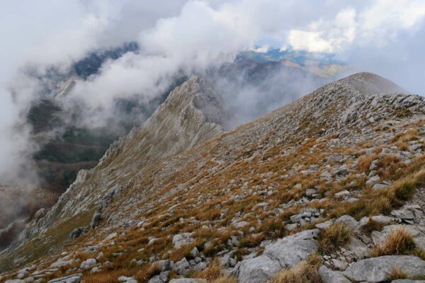
Walking to Raschötz Kreuz
After not too long you’ll see the Resciesa Hut in the distance, with a cross (Kreuz) on the hill behind it. The trail cuts across the moorland here, directly from the hut to the cross. You can see a small path marked out by a greener section of ground. The path leads off just before the hut.
If you keep to the leftmost path, this is the most efficient route to the top. You’ll see Raschötz cross in the distance, so you can’t get lost. Once you reach the summit, you can see the valley on the other side, the Alps in the distance, and Seceda and the impressive Fermeda peaks to your right.
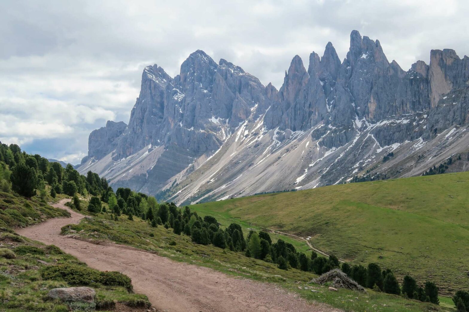
Hike from Raschötz to the Fermeda Peaks
After relaxing and admiring the views, continue along the path leading across the hillside and towards the pointy Fermeda peaks in the distance. It’s a lovely trail and very pleasant. Soon you’ll reach a junction at the beginning of the trees. Take the left to follow a path as it gradually descends through the trees and open areas, until heading slightly upwards to meet a larger track.
Turn left on the large track and it’s easy walking for several kilometres, all with fantastic views of the impressive Fermeda peaks. Eventually, you’ll reach a saddle and a junction. The main path leads onwards and downhill to Brogles hut, and a smaller path heads right down the grassy valley. Decide for yourself whether or not to go down to Brogles hut and return again. Alternatively, be content with just looking at the hut from afar.
The Hike down to Ortisei
The main descent now starts from the saddle, and it’s quite a long way down! Take the small path through the grassy valley, which then enters a lovely forest. The path number you should follow is number 5, always heading down, firstly signposted Seceda and then Ortisei (St Ulrich).
In a bit, you’ll see a cable car above you – this leads from Ortisei to Seceda. The path continues ever downwards, with some short sections that are quite steep and over slightly slippery damp cobblestones.
Eventually, you’ll cross beneath the cable car and come out at a little hamlet with a road. There is a bus from here back to Ortisei (St Ulrich) if you’re too tired to continue, but there’s nothing in the hamlet to amuse you while you wait.
Walking into Ortisei
Turn right along the main road, following route 5. After 500 metres, take the left into a lovely grassy meadow (now number 9). The path is fairly small and slightly overgrown in places. However, it’s easy walking and there are beautiful wildflowers in the meadow (before the grass is cut).
This path turns into a track, and soon you’ll reach a slightly out-of-place restaurant called Caffè Val d’Anna*. It’s a bit like a mountain hut, but also quite posh at the same time.
Turn right at the restaurant to follow the gravel trail along the river. This heads back towards the centre of Ortisei (St Ulrich). There are a couple of routes you can take, all leading to Ortisei, so whichever path you take should be fine.
The best route, however, continues to a children’s playground. Halfway through the playground, take the right on a track which then bends left and across the river. In a few hundred metres, the path heads across another bridge and you come out right at the parking garage at the base of the Seceda Cable Car. This is the end of the Raschötz and Brogles Hut Hike.
Guidebooks for Exploring the Dolomites


For more mountain hikes, check out our Germany Hiking Page or Italy Hiking Page.
Related Posts