By Vicky · Published Jun. 23rd, 2023 · Updated Jun. 27th, 2023
When you buy through links highlighted with an asterisk (*) on this site, we may earn a small affiliate commission at no cost to you.
This hiking route leads over the famous Fürstensteig to the top of Kuhgrat Peak, with amazing views over Liechtenstein.
Fürstensteig & Kuhgrat Peak Hiking Map
Get the route by downloading the .gpx or .kml file below. For navigation with Maps.me on your mobile phone, simply download the .kml file and open to add it to the Maps.me bookmarks.
Location
The Fürstensteig & Kuhgrat Peak hike starts from Gaflei Car Park. Alternatively, you can take the bus here to Gaflei Klinik bus stop, right at the car park.
Tips
- The car park can get busy on sunny summer weekends, so arrive early.
- Hiking Poles* are very useful for this hike, especially for the steep and narrow Fürstensteig section.
- Hotel Restaurant Kulm* is a very popular hotel near the start of this hike in Triesenberg.
- There are refreshments only at the start and end of this hike at Gaflei Stuba.
- For more nearby hikes, try Schönberg Peak or Rappenstein Peak, or check out our Liechtenstein Hiking Page.
Fürstensteig & Kuhgrat Peak Hiking Route

From Gaflei car park, leave the car park along the track to the right, in the opposite direction to the Gaflei Stuba. At the first junction turn left, following the hiking signs towards Fürstensteig. At the next corner, head straight onward along the smaller path, again following the hiking signs. The path heads gradually upwards through the forest, with one big zigzag.
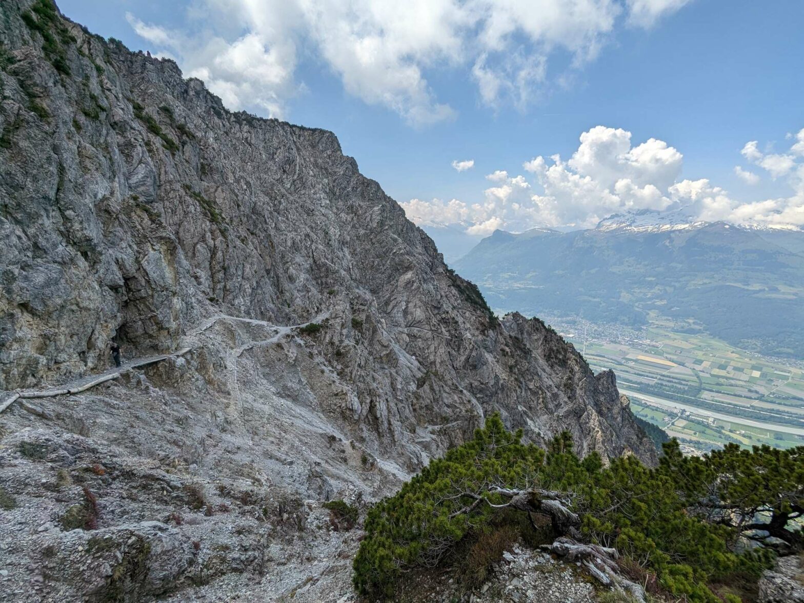
Hiking the Fürstensteig
Quite suddenly, the trees end and the main section of the Fürstensteig begins. It’s not much more than 1 km with 150 metres of climb, but it might take a surprisingly long time as you have to take it carefully and concentrate most of the way.
The route-finding itself is very easy because there’s only one path. There are fantastic views of the valley below, and the incredible path clinging to the hillside in front and behind you. This is what makes it one of Liechtenstein’s best hikes.
How difficult is the Fürstensteig Hike?
The Fürstensteig Hike is a red hiking route according to the colour-coding system used in Liechtenstein, Austria and Germany. In this system, blue is easy, red is intermediate and black is difficult routes. So, the Fürstensteig Hike is not that difficult, but you do need to be surefooted and not be afraid of heights. The path is narrow but fairly well maintained, and in places there are metal cables you can hold onto.
We hiked the Fürstensteig in late May and there were a few small patches of snow on the route. Crossing these was the most difficult bit, though there were already many footprints which were easy to tread in. Hiking poles* are very advantageous here.
Although it’s not that difficult, attempting the Fürstensteig route in poor visibility or wet conditions, when the rocks are slippery, is not recommended.
After a final zigzag, you’ll reach the end of the Fürstensteig and pass onto an easier trail. There are more fantastic views here, this time of the other side of the mountain, and there’s a very well-placed bench to enjoy it from.
Hiking to Kuhgrat Peak and Back
From here, you have the recommended option to hike up to Kuhgrat Peak before returning. From here, it’s 2.3 km with 280 metres climb to the top, all on a nice easy trail, taking about 45 minutes. To take this option, head left on the path just after the bench. Again, the route finding is easy because there are no other options.
The trail heads upwards to the ridge, with great views of both sides and soon you’ll be at the top of Kuhgrat. You can see most of Liechtenstein from here, not too difficult because the country’s so small.
Alpspitz Ridge and Downwards
After admiring the view, return back to the path junction near the bench. This time, continue onwards. The path becomes a little steep as it zigzags upwards, but it’s very wide in most places (cows walk over here twice a year). Soon you’ll reach the ridge top, with Alpspitz Peak to your right. The other side of the ridge is quite different, much less wild, with grassy fields and meadows.
Head right, down the track to the saddle. From here, in front and to the left you can see the ‘Middle Point of Liechtenstein’, the geographic centre of the country highlighted by a photo frame. The route now continues right, down the path towards the farm buildings. Following the track further, you eventually return back to the Gaflei car park. This is the end of the Fürstensteig & Kuhgrat Peak Hike.
Guidebooks for Hiking in the Alps


If you’re looking for more peaks to climb in Liechtenstein, try Schönberg Peak or Rappenstein Peak. Or, for a lovely shorter and very easy hike nearby, why not walk through hay meadows and barns? Alternatively, check out our Germany Hiking Page for more great hikes nearby and for walking tours of the famous Bavarian cities.
Related Posts


