By Vicky · Published Jun. 25th, 2023
When you buy through links highlighted with an asterisk (*) on this site, we may earn a small affiliate commission at no cost to you.
The superb but demanding hike up Rappenstein Peak from Steg is a classic mountain and ridge walk with amazing views all the way.
Rappenstein Peak Hiking Map
Get the route by downloading the .gpx or .kml file below. For navigation with Maps.me on your mobile phone, simply download the .kml file and open to add it to the Maps.me bookmarks.
Location
The Rappenstein Peak hike starts from a car park in Steg, just the other side of the tunnel from the Rhine Valley. Alternatively, you can take the bus to the bus stop in the car park called Steg Tunnel.
Tips
- The car park can get busy on sunny summer weekends, so arrive early or take the bus.
- There are not many places to stay in Steg, but good nearby options are Hotel Falknerei Galina* in Malbun or
Hotel Restaurant Kulm* in Triesenberg. - There’s a mountain hut (Alp Valüna) 4 km into the hike (open mid-May to October, 7am-9pm) serving food and drink.
- Hiking poles* are extremely useful on this hike – especially if there’s still snow left (near the top snow can last well into summer).
- For more hikes nearby, try Schönberg Peak or Kuhgrat Peak, or check out our Germany Hiking Page.
Rappenstein Peak Hiking Route
Walking from Steg up Valüna Valley

From the car park, walk along the main road for a few hundred metres, through the centre of Steg village. Take the track leading right, then head left. Follow this track as it bends around the corner following a row of cute mountain cottages, with lovely views up Valüna Valley. Soon the track ends and becomes a small path leading down to another set of cottages.
Continue on the track across the lake and take the first left along the path next to the river. The route now follows the river for just over 2.5 km to Alp Valüna mountain hut. You have a couple of options – to walk on one side of the river or the other, or to take the track slightly further from the river. All these options will bring you to Alp Valüna, but the path by the river is perhaps the nicest way. You have to open and close a few string fences on the way.
Heading upwards from Valüna Valley
The track continues after the hut, heading further up the valley. About 1.2 km after the hut, there’s a trail junction. The hike up Rappenstein Peak heads along the right-most track, contouring around the head of the valley. After crossing a couple of streams, the track bends into some trees and meadows.
Soon you leave the trees again and wind up a bendy track through a grassy meadow, leading quite steeply upwards. Eventually, you’ll reach a large farm building where the route flattens again. On this section there are two options to shorten the route – see box below.
Bad Weather Routes / Shortcuts
If the weather is bad, there are a couple of options you can take to avoid the highest and most difficult section of the Rappenstein Peak Hike. Via the full route up Rappenstein Peak, it’s 18.5 km with 1100 metres climb. If you’re tired the options below make it quite a lot shorter. The peak route is not recommended in heavy rain or low visibility.
The shortest option is a lovely, easy path back from halfway up the valley sides, leading directly back to Steg. It’s easy to miss – at the corner of a bend in one of the zigzags – so look out for it if you decide to take this shorter route. From where this route leaves the main trail, it’s roughly 5 km with very little climb back to Steg. This makes the hike 12.5 km with 500 m climb in total.
The second shortcut option avoids both the most difficult scramble near the top of Rappenstein Peak and a narrow, slightly scary path along a short section of the ridge. However, it still includes most of the ridge walk. The option leaves at the large farm building, heading right at the track junction. This makes the hike 14.7 km with 750 m climb in total.
Continuing the Hike to Rappenstein Peak
To continue on the main hike up Rappenstein Peak, continue on the track past the large farm building. The track becomes smaller and leads into a bowl. When we walked up Rappenstein Peak in late May, there was still some snow in this bowl so the path was slightly unclear. However, there was no difficulty and we could fairly easily just walk up the snow-free grass, heading to the ridge above.
This is a steep section of the hike, and the path has many short zigzags, but you’ll soon be at the ridge. From the junction at the top you can see over the side, into the main Rhine Valley. The ridge is quite narrow, so not for people afraid of heights.
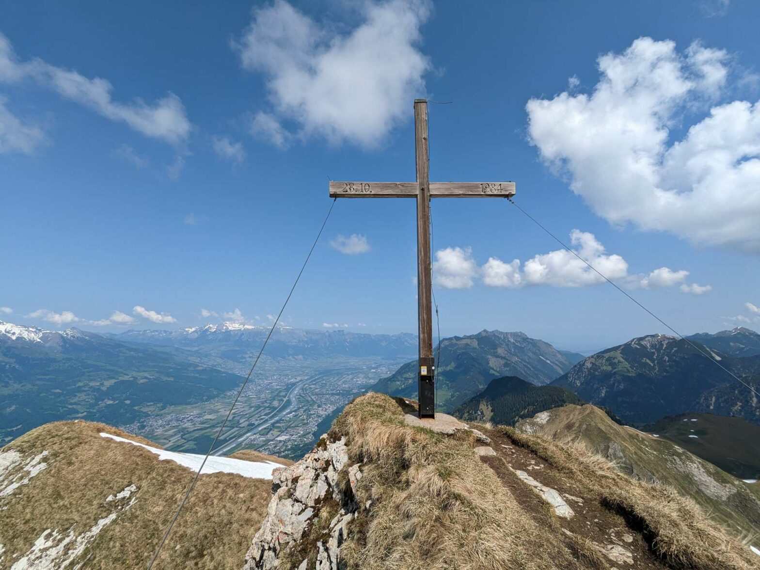
The Final Push to Rappenstein Summit
From here, Rappenstein Peak is roughly 0.5 kilometres to your left. The first section involves a small amount of scrambling – secured in most places with a cable. It’s not that difficult, but you have to be surefooted. After that, the hike to the top is over a gently inclined plateau. When we were there in late May, a snowfield still covered a large part of this plateau.
There were many previous footprint tracks through the snow, some of which were quite deep. These were fairly easy to follow, but hiking poles* are highly recommended. The route is a little steep in places, and the snow can be slippery. You don’t want to slide down the mountain.
The views are excellent at the top, with 360-degree visibility. After you’ve enjoyed the scenery, the path leads back down to the junction on the ridge. The trail continues along the ridge to Goldlochspitz. The first section of the path is very narrow and along a steep slope, so not for those afraid of heights. If you do find this too scary, you can return to the large farmhouse and take an easy route from there, though it adds on some distance and climb.
Walking along the Ridge
After Goldlochspitz, the path becomes easier and there isn’t too much difficulty for the rest of the way. The path just continues along near the top of the ridge, with some ups and down. After walking several kilometres through meadows and trees, the surroundings suddenly change to heather and friendly moorland. And soon, the path begins heading downwards.
Eventually, you’ll reach a small road and a little tunnel through the ridge. Turn right here. Walk down the road and just around the corner below the large mountain hut. Take the path to the right through the field here. This leads back down to the village of Steg and the end of the Rappenstein Peak Hike.
Guidebooks for Hiking in the Alps


If you’re looking for more peaks to climb in Liechtenstein, try Schönberg Peak or Kuhgrat Peak (both slightly easier options). Or, for a lovely shorter and very easy hike nearby, why not walk through hay meadows and barns? Alternatively, check out our Germany Hiking Page for more great hikes nearby and for walking tours of the famous Bavarian cities.
Related Posts


